
| Memorials | : | 0 |
| Location | : | Kinston, Coffee County, USA |
| Coordinate | : | 31.2012350, -86.1803550 |
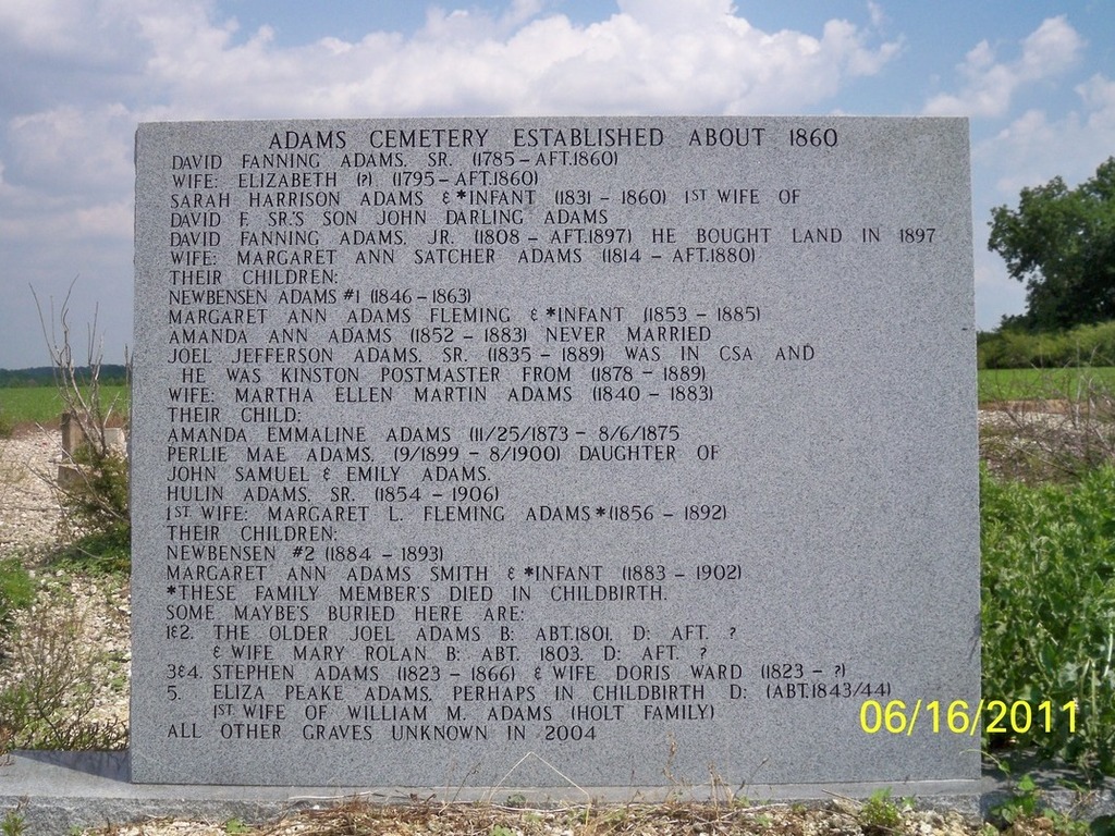
| Description | : | HISTORY: The Adams Cemetery was established about 1860 on land cleared, farmed and homesteaded by the family of David Fanning Adams Sr. The old Adams family cemetery is located southwest of Kinston, Alabama, near the present-day terminus of CR 483. Over the years, the original grave markers were lost to neglect and vandalism. However, the cemetery is known to include twenty-six unmarked graves, including the grave of the family patriarch and Alabama pioneer, David Fanning Adams Sr. DIRECTIONS: Begin at the intersection of CR 52 and CR 189 at Kinston, Alabama. From this point, proceed south on CR 479. Look... Read More |
frequently asked questions (FAQ):
-
Where is Adams Cemetery?
Adams Cemetery is located at Kinston, Coffee County ,Alabama ,USA.
-
Adams Cemetery cemetery's updated grave count on graveviews.com?
0 memorials
-
Where are the coordinates of the Adams Cemetery?
Latitude: 31.2012350
Longitude: -86.1803550


Nearby Cemetories:
1. Saint Pauls Cemetery
Kinston, Coffee County, USA
Coordinate: 31.2166996, -86.1650009
2. Kinston Cemetery
Kinston, Coffee County, USA
Coordinate: 31.2194004, -86.1688995
3. Harrison Cemetery
Kinston, Coffee County, USA
Coordinate: 31.2082996, -86.1449966
4. Lowery Cemetery
Lowery, Geneva County, USA
Coordinate: 31.1671220, -86.1432950
5. Beulah Church Cemetery
Opp, Covington County, USA
Coordinate: 31.2299995, -86.2311020
6. Weeks Assembly of God Church Cemetery
Kinston, Coffee County, USA
Coordinate: 31.2185802, -86.1098404
7. Rhoades Cemetery
Coffee County, USA
Coordinate: 31.2630997, -86.1611023
8. New Chapel Cemetery
Coffee County, USA
Coordinate: 31.2630997, -86.1611023
9. Bethany Baptist Church Cemetery
Opp, Covington County, USA
Coordinate: 31.2601376, -86.2176971
10. Macedonia Cemetery
Coffee County, USA
Coordinate: 31.2182999, -86.0986023
11. Old Town Cemetery
Rhoades, Coffee County, USA
Coordinate: 31.2600002, -86.1278000
12. Weeks Chapel Cemetery
Lowery, Geneva County, USA
Coordinate: 31.1512000, -86.1164000
13. Friendship Baptist Church Cemetery
Ino, Coffee County, USA
Coordinate: 31.2335760, -86.0999150
14. Peaceful Acres Memorial Gardens
Opp, Covington County, USA
Coordinate: 31.2635994, -86.2328033
15. Earlytown Church of Christ Cemetery
Earlytown, Geneva County, USA
Coordinate: 31.1303330, -86.1339160
16. Johns Cemetery
Opp, Covington County, USA
Coordinate: 31.2341232, -86.2721176
17. West County Line Cemetery
Opp, Covington County, USA
Coordinate: 31.2866993, -86.1992035
18. Alberton Cemetery
Ino, Coffee County, USA
Coordinate: 31.2782993, -86.1307983
19. County Line Cemetery
Opp, Covington County, USA
Coordinate: 31.2872009, -86.2042007
20. Crews Cemetery
Geneva County, USA
Coordinate: 31.1632996, -86.0832977
21. Flat Creek Cemetery
Earlytown, Geneva County, USA
Coordinate: 31.1107998, -86.1464005
22. Hardin Street Cemetery
Opp, Covington County, USA
Coordinate: 31.2754520, -86.2549820
23. Welcome the Way Cemetery
Onycha, Covington County, USA
Coordinate: 31.2343063, -86.2903976
24. Ino Cemetery
Coffee County, USA
Coordinate: 31.2728004, -86.0931015