
| Memorials | : | 0 |
| Location | : | Estill, Washington County, USA |
| Coordinate | : | 33.2215370, -90.8708800 |
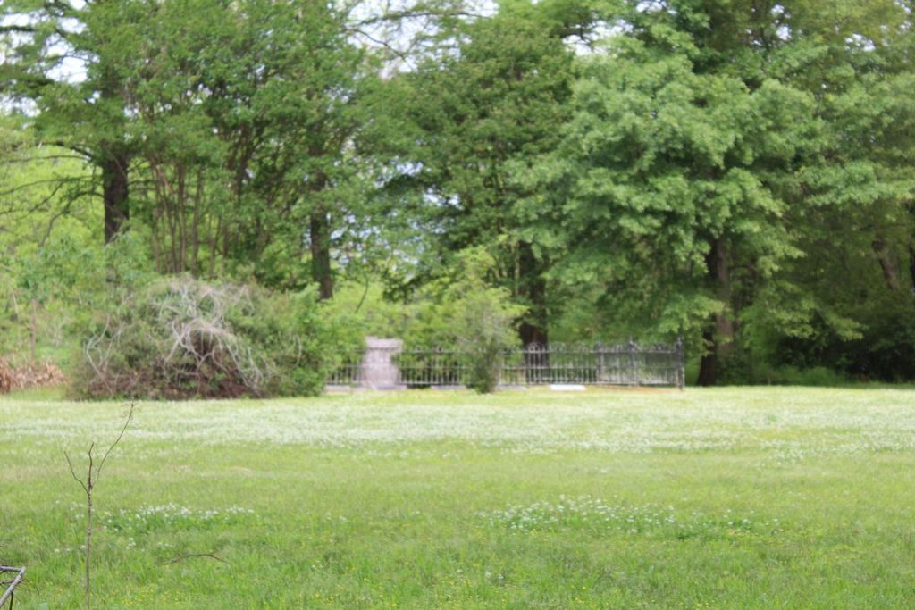
| Description | : | Small family cemetery with 9 members of the Aldridge family. It is well kept with the original wrought iron fence around it. From Highway 82 at Leland, turn south on OLD Highway 61 South. It is 13 miles south. When you cross Highway 438, it is 3.7 miles further and on the west side of the road. The cemetery is in the yard of the old Aldridge plantation home. It is not visible from the highway. |
frequently asked questions (FAQ):
-
Where is Aldridge Family Cemetery?
Aldridge Family Cemetery is located at Estill, Washington County ,Mississippi ,USA.
-
Aldridge Family Cemetery cemetery's updated grave count on graveviews.com?
0 memorials
-
Where are the coordinates of the Aldridge Family Cemetery?
Latitude: 33.2215370
Longitude: -90.8708800
Nearby Cemetories:
1. Estill Family Cemetery
Washington County, USA
Coordinate: 33.2132965, -90.8613263
2. Magruder Cemetery
Washington County, USA
Coordinate: 33.2421989, -90.8647003
3. Macedonia Cemetery
Washington County, USA
Coordinate: 33.2449989, -90.8814011
4. Saint Luke Cemetery
Empire, Washington County, USA
Coordinate: 33.2197800, -90.8326900
5. Sanders Memorial Garden Cemetery
Hollandale, Washington County, USA
Coordinate: 33.1819000, -90.8599000
6. New Foundation Cemetery
Hollandale, Washington County, USA
Coordinate: 33.1794014, -90.8488998
7. Arcola Cemetery
Arcola, Washington County, USA
Coordinate: 33.2701800, -90.8847100
8. Hollandale Cemetery
Hollandale, Washington County, USA
Coordinate: 33.1756000, -90.8422900
9. Arcola Methodist Church Cemetery
Arcola, Washington County, USA
Coordinate: 33.2828600, -90.8786700
10. Bellamy Cemetery
Washington County, USA
Coordinate: 33.1556015, -90.8424988
11. Mount Avery Cemetery
Tralake, Washington County, USA
Coordinate: 33.2696400, -90.8098800
12. Paxton Cemetery
Washington County, USA
Coordinate: 33.2919006, -90.8831024
13. Cletonia Cemetery
Washington County, USA
Coordinate: 33.1497002, -90.8460999
14. Mount Zion Church Cemetery
Darlove, Washington County, USA
Coordinate: 33.2278600, -90.7759300
15. Sunrise Missionary Baptist Church Cemetery
Tralake, Washington County, USA
Coordinate: 33.2695900, -90.7929600
16. Huddleston Cemetery
Washington County, USA
Coordinate: 33.1422005, -90.8411026
17. Mount Zion Trinity Cemetery
Wilmot, Washington County, USA
Coordinate: 33.3045100, -90.8938400
18. Section 16 Cemetery
Washington County, USA
Coordinate: 33.1394005, -90.8317032
19. Pleasant Grove Cemetery
Darlove, Washington County, USA
Coordinate: 33.1846900, -90.7700800
20. Fourmile Cemetery
Washington County, USA
Coordinate: 33.2366982, -90.7619019
21. Mount Carmel M.B. Church Cemetery
Wilmot, Washington County, USA
Coordinate: 33.3136660, -90.8959910
22. Kindling Altar Cemetery
Washington County, USA
Coordinate: 33.3280983, -90.8169022
23. Mount Zion Cemetery
Percy, Washington County, USA
Coordinate: 33.1030998, -90.8688965
24. Zion Field Church Cemetery
Kinlock, Sunflower County, USA
Coordinate: 33.2736500, -90.7328400