
| Memorials | : | 0 |
| Location | : | Knettishall, St Edmundsbury Borough, England |
| Website | : | www.suffolkchurches.co.uk/knettishall.htm |
| Coordinate | : | 52.3849000, 0.8974000 |
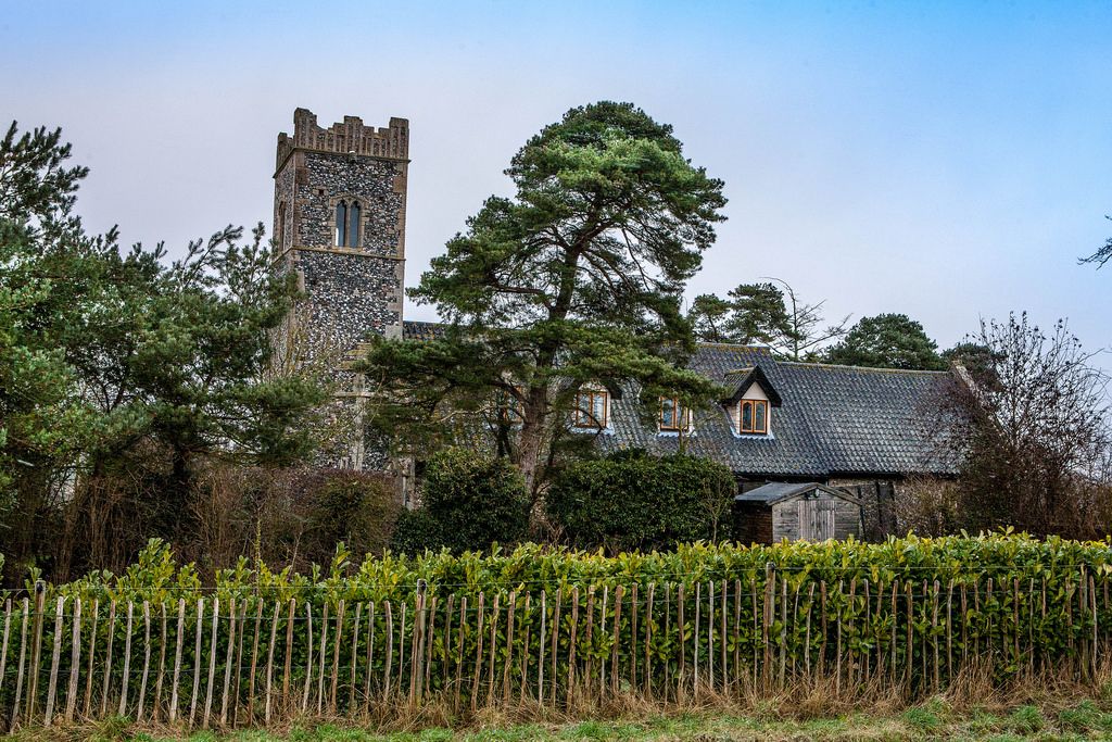
| Description | : | All Saints, Knettishall, is one of a number of Medieval churches in north Suffolk that fell into disuse and dereliction in the early years of the 20th century. Its interior furnishings were dispersed in 1933, mainly to the nearby village of Riddlesworth. The church was marooned on the Coney Weston USAF base throughout WWII and into the fifties. By this time, the church was disused and decaying. Today, All Saints sits proudly on the edge of the former airbase; its tower gap-toothed but secure and a large house built into the lower walls of the former nave. The original windows... Read More |
frequently asked questions (FAQ):
-
Where is All Saints Churchyard?
All Saints Churchyard is located at Knettishall, St Edmundsbury Borough ,Suffolk , IP22England.
-
All Saints Churchyard cemetery's updated grave count on graveviews.com?
0 memorials
-
Where are the coordinates of the All Saints Churchyard?
Latitude: 52.3849000
Longitude: 0.8974000
Nearby Cemetories:
1. St Peter's Churchyard
Riddlesworth, Breckland Borough, England
Coordinate: 52.3941990, 0.8888780
2. St Mary Churchyard
Coney Weston, St Edmundsbury Borough, England
Coordinate: 52.3681000, 0.8946000
3. Hopton Methodist Churchyard
Hopton, St Edmundsbury Borough, England
Coordinate: 52.3737430, 0.9253540
4. All Saints Churchyard
Hopton, St Edmundsbury Borough, England
Coordinate: 52.3730420, 0.9275760
5. St Mary Churchyard
Market Weston, St Edmundsbury Borough, England
Coordinate: 52.3649970, 0.9223330
6. Market Weston War Memorial
Market Weston, St Edmundsbury Borough, England
Coordinate: 52.3648470, 0.9225730
7. Barningham Cemetery
Barningham, St Edmundsbury Borough, England
Coordinate: 52.3553880, 0.8888050
8. St Andrews Barningham
Barningham, St Edmundsbury Borough, England
Coordinate: 52.3547760, 0.8879500
9. St. John The Baptist Churchyard
Garboldisham, Breckland Borough, England
Coordinate: 52.3961130, 0.9444950
10. St Andrew's Churchyard
Blo' Norton, Breckland Borough, England
Coordinate: 52.3784830, 0.9549700
11. St Nicholas Church
Thelnetham, St Edmundsbury Borough, England
Coordinate: 52.3656000, 0.9635000
12. St. Andrew's Churchyard
Brettenham, Breckland Borough, England
Coordinate: 52.4141040, 0.8397190
13. St Peter Churchyard
Hepworth, St Edmundsbury Borough, England
Coordinate: 52.3356090, 0.9159050
14. St. Mary The Virgin Churchyard
Bridgham, Breckland Borough, England
Coordinate: 52.4355480, 0.8783780
15. East Harling Cemetery
East Harling, Breckland Borough, England
Coordinate: 52.4336498, 0.9346589
16. St Peter and St Paul Churchyard
East Harling, Breckland Borough, England
Coordinate: 52.4373860, 0.9304050
17. St. Mary's Churchyard
Hinderclay, Mid Suffolk District, England
Coordinate: 52.3521190, 0.9749790
18. St Peter & St Paul Church
Norwich, City of Norwich, England
Coordinate: 52.4408990, 0.9299175
19. St. John the Baptist Cemetery
Stanton, St Edmundsbury Borough, England
Coordinate: 52.3266320, 0.8779620
20. St Nicholas Churchyard
North Lopham, Breckland Borough, England
Coordinate: 52.4029430, 0.9920510
21. Methodist Churchyard
North Lopham, Breckland Borough, England
Coordinate: 52.4053630, 0.9920680
22. All Saints Churchyard
Stanton, St Edmundsbury Borough, England
Coordinate: 52.3238580, 0.8835220
23. St Andrew Churchyard
South Lopham, Breckland Borough, England
Coordinate: 52.3957830, 0.9969650
24. St Andrews Churchyard
Roudham, Breckland Borough, England
Coordinate: 52.4472050, 0.8768120