
| Memorials | : | 0 |
| Location | : | Zanesville, Montgomery County, USA |
| Coordinate | : | 39.2847550, -89.6359060 |
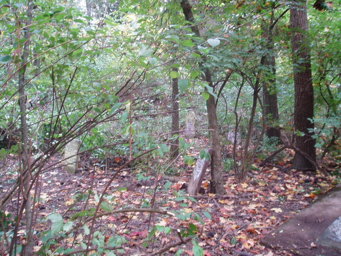
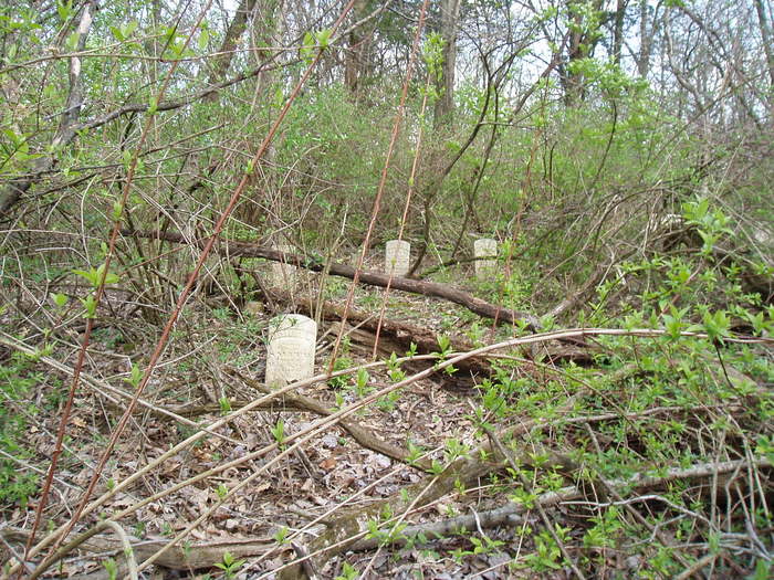
| Description | : | Allen Cemetery is located in Section 27 of Zanesville (Range 10 N 5 W), Montgomery Co., Illinois. From I-55 take the Illinois Highway 108 Exit. Head north on East Frontage Road and turn right onto Trailers Lane. The cemetery can be accessed from a small path from the property owners front yard (please make contact with property owner before heading up to cemetery). About 200-250 ft down the path is a large tree on the right. Cut up the hill from this tree. A small gated area will 1st been seen. Trees and brush... Read More |
frequently asked questions (FAQ):
-
Where is Allen Cemetery?
Allen Cemetery is located at Zanesville, Montgomery County ,Illinois ,USA.
-
Allen Cemetery cemetery's updated grave count on graveviews.com?
0 memorials
-
Where are the coordinates of the Allen Cemetery?
Latitude: 39.2847550
Longitude: -89.6359060
Nearby Cemetories:
1. Crawford Cemetery
Zanesville, Montgomery County, USA
Coordinate: 39.2773132, -89.6322174
2. Martin Cemetery
Zanesville, Montgomery County, USA
Coordinate: 39.2902679, -89.6193390
3. Williams Cemetery
Zanesville, Montgomery County, USA
Coordinate: 39.2807045, -89.6080933
4. Cedar Ridge Cemetery
Honey Bend, Montgomery County, USA
Coordinate: 39.2565020, -89.6275310
5. Roberts Cemetery
Montgomery County, USA
Coordinate: 39.2531013, -89.6007996
6. Cass Cemetery
Raymond, Montgomery County, USA
Coordinate: 39.2733002, -89.5682983
7. Raymond City Cemetery
Raymond, Montgomery County, USA
Coordinate: 39.3200989, -89.5809021
8. Saint Raymond Cemetery
Raymond, Montgomery County, USA
Coordinate: 39.2991982, -89.5663986
9. Asbury Cemetery
Raymond, Montgomery County, USA
Coordinate: 39.3013992, -89.5661011
10. Carrico Cemetery
Macoupin County, USA
Coordinate: 39.2496986, -89.7039032
11. Cherry Grove Cemetery
Montgomery County, USA
Coordinate: 39.2355500, -89.5825100
12. Zanesville City Cemetery
Zanesville, Montgomery County, USA
Coordinate: 39.3345642, -89.6896362
13. Wood Cemetery
Litchfield, Montgomery County, USA
Coordinate: 39.2216300, -89.5947400
14. Elmwood Cemetery
Macoupin County, USA
Coordinate: 39.2844130, -89.7369280
15. Street Cemetery
Waggoner, Montgomery County, USA
Coordinate: 39.3551320, -89.6806890
16. Dwight E Street Cemetery
Zanesville, Montgomery County, USA
Coordinate: 39.3553740, -89.6810720
17. Bethel Ridge Cemetery
Atwater, Macoupin County, USA
Coordinate: 39.3072014, -89.7350006
18. Turner Farm Cemetery
Butler, Montgomery County, USA
Coordinate: 39.2175280, -89.5652200
19. Gray Cemetery
Litchfield, Montgomery County, USA
Coordinate: 39.2012700, -89.5890700
20. Providence Cemetery
Waggoner, Montgomery County, USA
Coordinate: 39.3644150, -89.6981340
21. Elm Lawn Memorial Park
Litchfield, Montgomery County, USA
Coordinate: 39.1821070, -89.6314860
22. Sulphur Springs Cemetery
Atwater, Macoupin County, USA
Coordinate: 39.3675000, -89.7184400
23. Wares Grove Cemetery
Butler, Montgomery County, USA
Coordinate: 39.2284400, -89.5203990
24. Edgewood Cemetery
Litchfield, Montgomery County, USA
Coordinate: 39.1786003, -89.6222000