
| Memorials | : | 9 |
| Location | : | Armatree, Gilgandra Shire, Australia |
| Coordinate | : | -31.4235363, 148.5125427 |
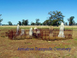
| Description | : | "Sunnyside" is a privatly owned cemetery located on the northern side of the Castlereagh Highway some 5km from Armatree north of Gilgandra in New South Wales Central West. The cemetery is visible from the highway. This small private cemetery contains eight marked graves surrounded by wrought iron enclosures that protect them from live stock. It contains burials dating from 1885 to 1930. The property is Privately owned and maintained. Access to the cemetery is available only with permission from the landholder. |
frequently asked questions (FAQ):
-
Where is Armatree Sunnyside Cemetery?
Armatree Sunnyside Cemetery is located at Armatree, Gilgandra Shire ,New South Wales ,Australia.
-
Armatree Sunnyside Cemetery cemetery's updated grave count on graveviews.com?
9 memorials
-
Where are the coordinates of the Armatree Sunnyside Cemetery?
Latitude: -31.4235363
Longitude: 148.5125427
Nearby Cemetories:
1. Gulargambone General Cemetery
Gulargambone, Coonamble Shire, Australia
Coordinate: -31.3394870, 148.4695380
2. Curban General Cemetery
Curban, Gilgandra Shire, Australia
Coordinate: -31.5280680, 148.6062240
3. Gilgandra General Cemetery
Gilgandra, Gilgandra Shire, Australia
Coordinate: -31.7130465, 148.6877720
4. Tooraweenah General Cemetery
Tooraweenah, Gilgandra Shire, Australia
Coordinate: -31.4347740, 148.9113770
5. Coonamble Old Cemetery
Coonamble, Coonamble Shire, Australia
Coordinate: -30.9572410, 148.3954020
6. Coonamble Cemetery
Coonamble, Coonamble Shire, Australia
Coordinate: -30.9609390, 148.3749530
7. Lone Graves
Coonamble, Coonamble Shire, Australia
Coordinate: -30.9543520, 148.3875270
8. Quambone Cemetery
Quambone, Coonamble Shire, Australia
Coordinate: -30.9281200, 147.8858950
9. Trangie General Cemetery
Trangie, Narromine Shire, Australia
Coordinate: -32.0342840, 147.9731270
10. Western Districts Memorial Park
Dubbo, Dubbo Regional Council, Australia
Coordinate: -32.2045930, 148.6267630
11. New Dubbo Cemetery
Dubbo, Dubbo Regional Council, Australia
Coordinate: -32.2323520, 148.6433290
12. Elong Elong Cemetery
Elong Elong, Dubbo Regional Council, Australia
Coordinate: -32.1117050, 149.0363750
13. Old Dubbo Cemetery
Dubbo, Dubbo Regional Council, Australia
Coordinate: -32.2403680, 148.6283760
14. Lone Graves
Ballimore, Dubbo Regional Council, Australia
Coordinate: -32.2456190, 148.6043360
15. Narromine General Cemetery
Narromine, Narromine Shire, Australia
Coordinate: -32.2481700, 148.2424500
16. Narromine War Cemetery
Narromine, Narromine Shire, Australia
Coordinate: -32.2528038, 148.2276306
17. Dubbo Pioneer Cemetery
Dubbo, Dubbo Regional Council, Australia
Coordinate: -32.3147740, 148.6243340
18. Gwabegar General Cemetery
Gwabegar, Narrabri Shire, Australia
Coordinate: -30.6070210, 148.9855040
19. Geurie Cemetery
Geurie, Dubbo Regional Council, Australia
Coordinate: -32.4118100, 148.8326300
20. Pilliga Cemetery
Pilliga, Narrabri Shire, Australia
Coordinate: -30.3587300, 148.8886100
21. Spicers Creek Cemetery
Wellington, Dubbo Regional Council, Australia
Coordinate: -32.3872640, 149.1681980
22. Bodangora General Cemetery
Bodangora, Dubbo Regional Council, Australia
Coordinate: -32.4502270, 149.0323310
23. Nyngan General Cemetery
Nyngan, Bogan Shire, Australia
Coordinate: -31.5738770, 147.2066920
24. Lambing Hill Cemetery
Goolma, Mid-Western Regional Council, Australia
Coordinate: -32.3552950, 149.2623350