
| Memorials | : | 0 |
| Location | : | Lamar, Barton County, USA |
| Coordinate | : | 37.4754500, -94.3248900 |
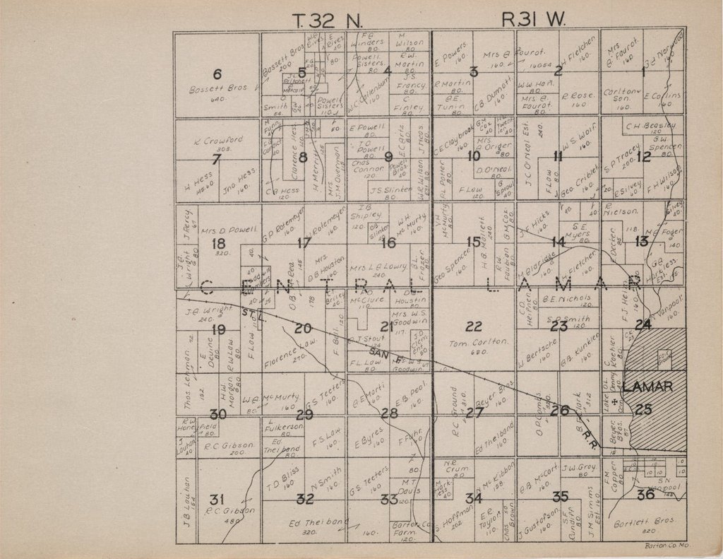
| Description | : | In the 1886 Historical Atlas of Barton County, Missouri, the 120 acres that became the Barton County Poor Farm in Township 32 North, Range 31 West in the Southeast quarter of Section 33, was owned by L. Sharp. In 1903, the 120 acres are listed as "County Farm" and in 1930, the Plat Book of Barton County, Missouri lists it as "Barton Co. Farm." The Barton County Poor Farm was enumerated in 1900, 1910, 1920, 1930, and 1940 in rural Central Township. I hope to record as many burials of the Barton County Poor Farm residents as possible from various records,... Read More |
frequently asked questions (FAQ):
-
Where is Barton County Poor Farm Cemetery?
Barton County Poor Farm Cemetery is located at Lamar, Barton County ,Missouri ,USA.
-
Barton County Poor Farm Cemetery cemetery's updated grave count on graveviews.com?
0 memorials
-
Where are the coordinates of the Barton County Poor Farm Cemetery?
Latitude: 37.4754500
Longitude: -94.3248900
Nearby Cemetories:
1. Saint Marys Cemetery
Lamar Heights, Barton County, USA
Coordinate: 37.4958000, -94.2968979
2. Lake Cemetery
Lamar Heights, Barton County, USA
Coordinate: 37.4956017, -94.2957993
3. Oak Grove Cemetery
Oakton, Barton County, USA
Coordinate: 37.4556007, -94.3544006
4. Memory Gardens Cemetery
Lamar, Barton County, USA
Coordinate: 37.4854000, -94.2663900
5. East Side Cemetery
Lamar, Barton County, USA
Coordinate: 37.4878006, -94.2619019
6. Killey Cemetery
Boston, Barton County, USA
Coordinate: 37.4163100, -94.3129100
7. Forest Grove Cemetery
Lamar, Barton County, USA
Coordinate: 37.4338500, -94.2606400
8. Nigh Cemetery
Lamar, Barton County, USA
Coordinate: 37.5341988, -94.2643967
9. Apostolic Christian Cemetery
Barton County, USA
Coordinate: 37.4301340, -94.4050990
10. Iantha Cemetery
Iantha, Barton County, USA
Coordinate: 37.5250015, -94.4049988
11. Waters Cemetery
Barton County, USA
Coordinate: 37.3708000, -94.3647003
12. Fair View Cemetery
Barton County, USA
Coordinate: 37.4914017, -94.1864014
13. Mount Carmel Cemetery
Golden City, Barton County, USA
Coordinate: 37.3964830, -94.1990300
14. Tabler-Yale Cemetery
Jasper, Jasper County, USA
Coordinate: 37.3471830, -94.3335910
15. Pierce Cemetery
Barton County, USA
Coordinate: 37.4207993, -94.4736023
16. Bakers Grove Cemetery
Barton County, USA
Coordinate: 37.6063995, -94.3516998
17. Green Lawn Cemetery
Jasper, Jasper County, USA
Coordinate: 37.3392850, -94.3106530
18. Moorehead Cemetery
Bushnell, Barton County, USA
Coordinate: 37.4902100, -94.1513600
19. Walnut Grove Cemetery
Jasper, Jasper County, USA
Coordinate: 37.3368020, -94.3412630
20. Stafford Cemetery
Jasper, Jasper County, USA
Coordinate: 37.3342018, -94.3546982
21. Cook Cemetery
Milford, Barton County, USA
Coordinate: 37.5461130, -94.1567370
22. Barton City Cemetery
Liberal, Barton County, USA
Coordinate: 37.5774994, -94.4721985
23. Mitchell Cemetery
Jasper, Jasper County, USA
Coordinate: 37.3375015, -94.2283020
24. Howell Cemetery
Milford, Barton County, USA
Coordinate: 37.5621986, -94.1583023