
| Memorials | : | 0 |
| Location | : | Bóly, Bólyi járás, Hungary |
| Coordinate | : | 45.9675560, 18.5176390 |
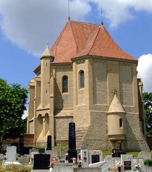
| Description | : | At the end of the 19th century, the village and 1752 manor house of Nemetboly became the property of the Prince of Montenuovo through marriage. His wife planned a family mausoleum combining several architectural designs with construction between 1879-1894. The yellow two-story structure has a red tile roof and red marble is used throughout the inside. The neo-Romanesque and neo-Gothic building is unique in Hungary. A wooden cross with a life-sized sculpture of Jesus Christ is part of the ornate building. A major renovation was done in 2005 . The village was renamed Boley... Read More |
frequently asked questions (FAQ):
-
Where is Batthyány-Montenuovo Mausoleum and Cemetery?
Batthyány-Montenuovo Mausoleum and Cemetery is located at Bóly, Bólyi járás ,Baranya ,Hungary.
-
Batthyány-Montenuovo Mausoleum and Cemetery cemetery's updated grave count on graveviews.com?
0 memorials
-
Where are the coordinates of the Batthyány-Montenuovo Mausoleum and Cemetery?
Latitude: 45.9675560
Longitude: 18.5176390
Nearby Cemetories:
1. Nagynyárád Cemetery
Nagynyárád, Mohácsi járás, Hungary
Coordinate: 45.9444020, 18.5832970
2. Marok Cemetery
Márok, Siklósi járás, Hungary
Coordinate: 45.8750041, 18.5047215
3. Székelyszabar
Székelyszabar, Mohácsi járás, Hungary
Coordinate: 46.0453269, 18.5997837
4. Palkonya Temető
Palkonya, Siklósi járás, Hungary
Coordinate: 45.8972909, 18.3924446
5. Himesháza Cemetery
Himesháza, Mohácsi járás, Hungary
Coordinate: 46.0807035, 18.5702104
6. Magyarbóly Jewish Cemetery
Magyarbóly, Siklósi járás, Hungary
Coordinate: 45.8385140, 18.4958400
7. Geresdlak
Geresdlak, Pécsváradi járás, Hungary
Coordinate: 46.1083500, 18.5236400
8. Geresd Cemetery
Geresdlak, Pécsváradi járás, Hungary
Coordinate: 46.1109274, 18.5294791
9. Illocska Cemetery
Illocska, Siklósi járás, Hungary
Coordinate: 45.8088555, 18.5154830
10. Franciscian Church of Máriagyüd
Siklós, Siklósi járás, Hungary
Coordinate: 45.8521300, 18.2988000
11. Pécsvárad Jewish Cemetery
Pécsvárad, Pécsváradi járás, Hungary
Coordinate: 46.1434870, 18.4053380
12. Cemetery at the Church of St Anne
Podolje, Općina Draž, Croatia
Coordinate: 45.8151780, 18.7282210
13. Petlovac Jewish Gravesite
Petlovac, Općina Petlovac, Croatia
Coordinate: 45.7548840, 18.5254390
14. Zengõvárkony
Zengővárkony, Pécsváradi járás, Hungary
Coordinate: 46.1738853, 18.4329987
15. Central Cemetery
Pécs, Pécsi járás, Hungary
Coordinate: 46.0514336, 18.2329273
16. Staro Groblje
Kotlina, Općina Kneževi Vinogradi, Croatia
Coordinate: 45.7942310, 18.7397130
17. Jewish cemetery
Pécs, Pécsi járás, Hungary
Coordinate: 46.0685060, 18.2113350
18. Pravoslavno Groblje
Kamenac, Općina Kneževi Vinogradi, Croatia
Coordinate: 45.7687957, 18.7023191
19. Groblje Karanac
Karanac, Općina Kneževi Vinogradi, Croatia
Coordinate: 45.7579059, 18.6761394
20. Groblje Kotlina
Kotlina, Općina Kneževi Vinogradi, Croatia
Coordinate: 45.7837120, 18.7376800
21. Katoličko Groblje
Kamenac, Općina Kneževi Vinogradi, Croatia
Coordinate: 45.7629940, 18.7089300
22. Groblje Suza br.2
Suza, Općina Kneževi Vinogradi, Croatia
Coordinate: 45.7868780, 18.7670689
23. Groblje Suza
Suza, Općina Kneževi Vinogradi, Croatia
Coordinate: 45.7818560, 18.7716910
24. Reformatsko Groblje
Knezevi Vinogradi, Općina Kneževi Vinogradi, Croatia
Coordinate: 45.7561820, 18.7370340