| Memorials | : | 0 |
| Location | : | Powiat szczecinecki, Poland |
| Coordinate | : | 53.5218500, 15.7046400 |
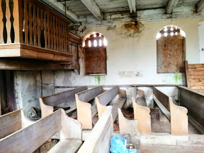
| Description | : | Bernsdorf Cemetery in Bernsdorf, Regenwalde, Pomerania. Today the Bernsdorf is known as Brzeznica is next to the church that is now a Catholic Church. The cemetery still has a few grave stone showing in it but the church has not been used. Most of it was destroyed after World War II as a means to help remove a reason for Germans to return. The names and information is derived from the Duplicate Church Records for Bernsdorf. The photograph is courtesy of Beata Zbonikowska. |
frequently asked questions (FAQ):
-
Where is Bernsdorf Cemetery?
Bernsdorf Cemetery is located at Powiat szczecinecki ,Zachodniopomorskie ,Poland.
-
Bernsdorf Cemetery cemetery's updated grave count on graveviews.com?
0 memorials
-
Where are the coordinates of the Bernsdorf Cemetery?
Latitude: 53.5218500
Longitude: 15.7046400
Nearby Cemetories:
1. Gienow Cemetery
Powiat łobeski, Poland
Coordinate: 53.5046395, 15.6666112
2. Cmentarz Komunalny w Storkowie
Szczecin, Miasto Szczecin, Poland
Coordinate: 53.4683200, 15.5949600
3. Kankelfitz Cemetery / Cmentarz Kąkolewice
Powiat łobeski, Poland
Coordinate: 53.5864932, 15.5623772
4. Cmentarz żydowski w Ińsku
Powiat stargardzki, Poland
Coordinate: 53.4384500, 15.5588700
5. Friedhof Dübzow
Powiat łobeski, Poland
Coordinate: 53.6137856, 15.5368558
6. Sielsko Cmentarz komunalny
Powiat łobeski, Poland
Coordinate: 53.5808105, 15.4683237
7. Evangelisch-Lutheranischer Friedhof von Horst
Powiat łobeski, Poland
Coordinate: 53.5444566, 15.4497067
8. Cieszyno Cmentarz
Powiat łobeski, Poland
Coordinate: 53.5207633, 15.4421941
9. Cmentarz Komunalny w Złocieńcu
Powiat drawski, Poland
Coordinate: 53.5272800, 16.0073900
10. Evangelisch Lutheranischer Friedhof v Vehlingsdorf
Powiat stargardzki, Poland
Coordinate: 53.5048258, 15.3935038
11. Evangelisch-lutherischer Friedhof Karow (Karwowo)
Powiat łobeski, Poland
Coordinate: 53.6983330, 15.5310640
12. Radowo Małe Cmentarz komunalny
Powiat łobeski, Poland
Coordinate: 53.6682735, 15.4410149
13. Cmentarz Komunalny w Chociwlu
Powiat stargardzki, Poland
Coordinate: 53.4684722, 15.3443890
14. Evangelisch-Lutheranischer Friedhof von Roggow A
Powiat łobeski, Poland
Coordinate: 53.6355946, 15.3581663
15. Cmentarz Dobra
Szczecin, Miasto Szczecin, Poland
Coordinate: 53.5859698, 15.3021461
16. Evangelisch-Lutheranischer Friedhof von Karkow
Powiat stargardzki, Poland
Coordinate: 53.4753318, 15.2854060
17. Voßberg
Powiat stargardzki, Poland
Coordinate: 53.4284883, 15.3067841
18. Voßberg
Powiat stargardzki, Poland
Coordinate: 53.4284883, 15.3067841
19. Friedhof Gross Benz
Powiat łobeski, Poland
Coordinate: 53.6141030, 15.2989770
20. Cmentarz Komunalny w Świdwinie
Szczecinek, Powiat szczecinecki, Poland
Coordinate: 53.7833330, 15.7666670
21. Cmentarz w Kania
Powiat stargardzki, Poland
Coordinate: 53.4989516, 15.2433455
22. Evangelisch-Lutheranischer Friedhof von Plantikow
Szczecin, Miasto Szczecin, Poland
Coordinate: 53.6006035, 15.2411593
23. Evangelisch-Lutheranischer Friedhof von Gardin
Powiat łobeski, Poland
Coordinate: 53.7899767, 15.4912805
24. Poland Evangelical Cemetery
Szczecin, Miasto Szczecin, Poland
Coordinate: 53.4125100, 15.2373470

