
| Memorials | : | 0 |
| Location | : | East Point, Fulton County, USA |
| Coordinate | : | 33.6661400, -84.4669250 |
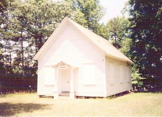
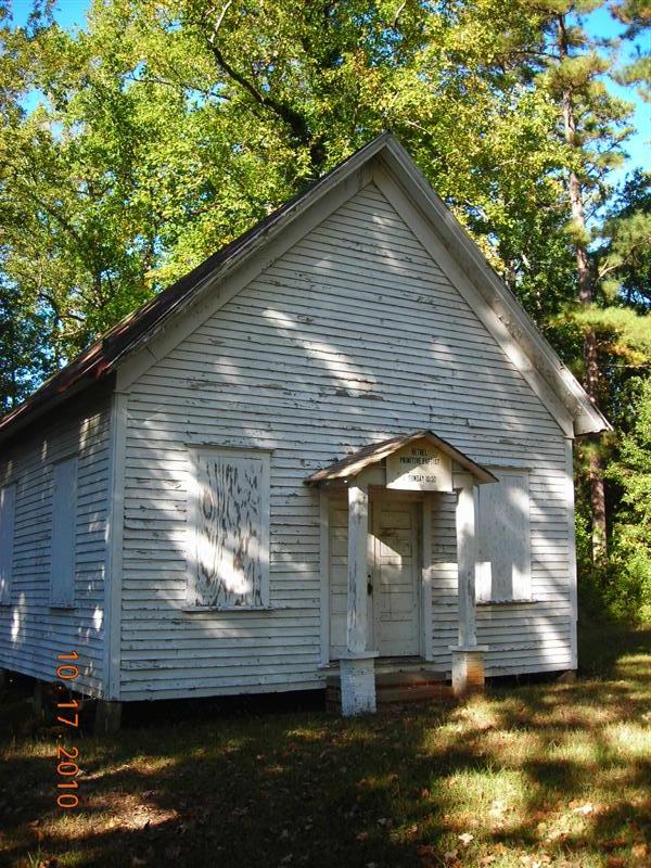
| Description | : | Bethel Primitive Baptist Church Cemetery is located on Stone Rd. near the corner of Washington Rd. It is in between the convenience store on Washington Rd. and the Stone Tree Apartments on Stone Rd. The church has been defunct for several years. While the front lawn is mowed frequently the cemetery behind the church is not maintained and is over grown. There are at least (and likely over) 100 burials here. The cemetery began as a Hornsby Family burial ground before it was used as a church cemetery. There is a fence around the property but it is not locked... Read More |
frequently asked questions (FAQ):
-
Where is Bethel Primitive Baptist Church Cemetery?
Bethel Primitive Baptist Church Cemetery is located at Stone Rd. Near corner of Washington Rd. East Point, Fulton County ,Georgia , 30344USA.
-
Bethel Primitive Baptist Church Cemetery cemetery's updated grave count on graveviews.com?
0 memorials
-
Where are the coordinates of the Bethel Primitive Baptist Church Cemetery?
Latitude: 33.6661400
Longitude: -84.4669250
Nearby Cemetories:
1. Hornsby Cemetery
East Point, Fulton County, USA
Coordinate: 33.6691760, -84.4634490
2. Mount Olive Baptist Church Cemetery
East Point, Fulton County, USA
Coordinate: 33.6600037, -84.4766693
3. College View Memorial Park
College Park, Fulton County, USA
Coordinate: 33.6589851, -84.4574509
4. John Lee Family Cemetery
East Point, Fulton County, USA
Coordinate: 33.6555310, -84.4837050
5. Saint Johns Episcopal Church
College Park, Fulton County, USA
Coordinate: 33.6606720, -84.4465880
6. College Park Cemetery
College Park, Fulton County, USA
Coordinate: 33.6577988, -84.4403000
7. Nellie Chapel Cemetery
East Point, Fulton County, USA
Coordinate: 33.6791670, -84.4417870
8. Ferguson-Stone Cemetery
Atlanta, Fulton County, USA
Coordinate: 33.6668060, -84.4972200
9. Slave Plot at Ferguson-Stone Cemetery
Atlanta, Fulton County, USA
Coordinate: 33.6668060, -84.4972200
10. Connally Cemetery
East Point, Fulton County, USA
Coordinate: 33.6926200, -84.4645500
11. Hillcrest Cemetery
East Point, Fulton County, USA
Coordinate: 33.6935997, -84.4475021
12. Ratterree Burial Ground
East Point, Fulton County, USA
Coordinate: 33.6884960, -84.4370130
13. Mount Olive Missionary Baptist Church Cemetery
Atlanta, Fulton County, USA
Coordinate: 33.6810950, -84.5064660
14. Mount Gilead Methodist Church Cemetery
Atlanta, Fulton County, USA
Coordinate: 33.6692330, -84.5157030
15. Bryant Family Cemetery
Atlanta, Fulton County, USA
Coordinate: 33.6913830, -84.5126960
16. Flat Rock Cemetery
Clayton County, USA
Coordinate: 33.6267014, -84.4360962
17. Ben Hill United Methodist Church Cemetery
Fulton County, USA
Coordinate: 33.6975000, -84.5101400
18. Roseland Cemetery
Atlanta, Fulton County, USA
Coordinate: 33.6823500, -84.4125600
19. Red Oak Cemetery
South Fulton, Fulton County, USA
Coordinate: 33.6227600, -84.4954500
20. Mount Zion Methodist Church Cemetery
Hapeville, Fulton County, USA
Coordinate: 33.6769100, -84.4084500
21. Utoy Primitive Baptist Church Cemetery
Atlanta, Fulton County, USA
Coordinate: 33.7177400, -84.4503600
22. Pope Family Burial Ground
Clayton County, USA
Coordinate: 33.6300556, -84.4111778
23. Gilbert Memorial Cemetery
Fulton County, USA
Coordinate: 33.6809502, -84.3981323
24. Greenwood Cemetery
Atlanta, Fulton County, USA
Coordinate: 33.7256012, -84.4539032