
| Memorials | : | 5 |
| Location | : | Kent, Jefferson County, USA |
| Coordinate | : | 38.7408120, -85.5442770 |
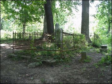
| Description | : | The cemetery is located in Republican Township on the east side of North Rogers Road (County Road 850 W) about 0.2 north of its intersection with W. Main Street (Indiana State Highway 256). Indiana Cemetery Locations, Volume 4, published by the Indiana Genealogical Society (April 2009), gives the primary cemetery name as Blankenship Cemetery with an alternate name of Old Kent Cemetery. The cemetery is listed in the Cemetery and Burial Grounds Registry of the Indiana Department of Natural Resources (DNR) and in the State Historical Architectural and Archaeological Research Database (SHAARD) with Cemetery Record Number CR-39-129 (Blankenship... Read More |
frequently asked questions (FAQ):
-
Where is Blankenship Cemetery?
Blankenship Cemetery is located at 240 North Rogers Road (County Road 850 W) Kent, Jefferson County ,Indiana , 47138USA.
-
Blankenship Cemetery cemetery's updated grave count on graveviews.com?
0 memorials
-
Where are the coordinates of the Blankenship Cemetery?
Latitude: 38.7408120
Longitude: -85.5442770

Nearby Cemetories:
1. Kent Cemetery
Kent, Jefferson County, USA
Coordinate: 38.7410630, -85.5449960
2. Landon Cemetery
Jefferson County, USA
Coordinate: 38.7400280, -85.5352730
3. White River Cemetery
Jefferson County, USA
Coordinate: 38.7224998, -85.5496979
4. Lloyd Cemetery
Wakefield, Jefferson County, USA
Coordinate: 38.7580510, -85.5543160
5. Lloyd Cemetery
Jefferson County, USA
Coordinate: 38.7580720, -85.5543400
6. Slippery Point Cemetery
Jefferson County, USA
Coordinate: 38.7220310, -85.5396660
7. Jackson - Wilson Farm Cemetery
Wakefield, Jefferson County, USA
Coordinate: 38.7600600, -85.5638500
8. Scotland Cemetery
Jefferson County, USA
Coordinate: 38.7528000, -85.5028000
9. Zoar Cemetery
Jefferson County, USA
Coordinate: 38.7349510, -85.4986267
10. Foster Farm Cemetery
Jefferson County, USA
Coordinate: 38.7687370, -85.5779300
11. Lawler Cemetery
Volga, Jefferson County, USA
Coordinate: 38.7831001, -85.5485992
12. Ford Cemetery
Smyrna, Jefferson County, USA
Coordinate: 38.7813160, -85.5271480
13. Lawler Cemetery #2
Wakefield, Jefferson County, USA
Coordinate: 38.7858170, -85.5416830
14. Hopewell Cemetery
Volga, Jefferson County, USA
Coordinate: 38.7815800, -85.5180340
15. Greenbriar Cemetery
Hanover, Jefferson County, USA
Coordinate: 38.7236640, -85.4891040
16. Carmel Associate United Presbyterian Cemetery
Hanover, Jefferson County, USA
Coordinate: 38.7022018, -85.5077972
17. Bumpkin Cemetery
Smyrna Township, Jefferson County, USA
Coordinate: 38.7841360, -85.5712610
18. McCarty Cemetery
Swanville, Jefferson County, USA
Coordinate: 38.7102700, -85.5945600
19. Neavill Cemetery
Jefferson County, USA
Coordinate: 38.7846985, -85.5136032
20. Liberty Cemetery
Jefferson County, USA
Coordinate: 38.7011375, -85.5839310
21. Lowe Cemetery
Smyrna, Jefferson County, USA
Coordinate: 38.7866200, -85.5719700
22. Shafer Cemetery
Hanover, Jefferson County, USA
Coordinate: 38.7269000, -85.4796000
23. Shiloh Cemetery
Jefferson County, USA
Coordinate: 38.7888050, -85.5172130
24. Sharon Hill Cemetery
Hanover, Jefferson County, USA
Coordinate: 38.6862793, -85.5432892