
| Memorials | : | 10 |
| Location | : | Bolivar, Denton County, USA |
| Coordinate | : | 33.3582497, -97.2410660 |
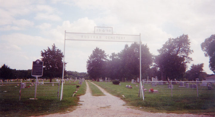
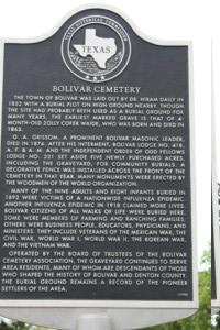
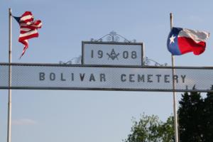
| Description | : | Location: FM 455, 3.7 mi. W of IH-35 Bolivar Cemetery is well kept and is still being used. Historical Marker: The town of Bolivar was laid out by Dr. Hiram Daily in 1852 with a burial plot on high ground nearby. Though the site had probably been used as a burial ground for many years, the earliest marked grave is that of 4-month-old Zolly Cofer Waide, who was born and died in 1863. G. A. Grissom, a prominent Bolivar Masonic leader, died in 1876. After his interment, Bolivar Lodge No. 418, A. F. & A. M. and the Independent Order... Read More |
frequently asked questions (FAQ):
-
Where is Bolivar Cemetery?
Bolivar Cemetery is located at Bolivar, Denton County ,Texas ,USA.
-
Bolivar Cemetery cemetery's updated grave count on graveviews.com?
7 memorials
-
Where are the coordinates of the Bolivar Cemetery?
Latitude: 33.3582497
Longitude: -97.2410660
Nearby Cemetories:
1. Knox Cemetery
Denton County, USA
Coordinate: 33.3781013, -97.2667007
2. Duck Creek Cemetery
Sanger, Denton County, USA
Coordinate: 33.3485985, -97.2022018
3. Gober-Wright Cemetery
Denton County, USA
Coordinate: 33.3206070, -97.2044650
4. Sanger Cemetery
Sanger, Denton County, USA
Coordinate: 33.3608017, -97.1603012
5. Blue Mound Cemetery
Sanger, Denton County, USA
Coordinate: 33.2933998, -97.1790009
6. Pollard Cemetery
Denton County, USA
Coordinate: 33.4192009, -97.3230972
7. Plainview Cemetery
Krum, Denton County, USA
Coordinate: 33.2909070, -97.3194810
8. Gribble Springs Cemetery
Sanger, Denton County, USA
Coordinate: 33.3128014, -97.1275024
9. Krum Jackson Cemetery
Krum, Denton County, USA
Coordinate: 33.2449989, -97.2433014
10. Trietsch Family Cemetery
Denton County, USA
Coordinate: 33.3067800, -97.1189700
11. Muslim Cemetery
Krum, Denton County, USA
Coordinate: 33.2399292, -97.3202972
12. Moss Cemetery
Cooke County, USA
Coordinate: 33.4369011, -97.3743973
13. Brier Family Cemetery
Denton County, USA
Coordinate: 33.2226460, -97.2686960
14. Immaculate Conception Catholic Church Columbarium
Denton, Denton County, USA
Coordinate: 33.2374350, -97.1622610
15. Cogburn Cemetery
Leo, Cooke County, USA
Coordinate: 33.4542007, -97.3657990
16. Era Cemetery
Era, Cooke County, USA
Coordinate: 33.5018997, -97.2866974
17. Church of Saint David of Wales Columbarium
Denton, Denton County, USA
Coordinate: 33.2197830, -97.1555770
18. Green Valley Cemetery
Green Valley, Denton County, USA
Coordinate: 33.3112984, -97.0630798
19. Ozment Cemetery
Burns City, Cooke County, USA
Coordinate: 33.5086098, -97.2909012
20. Tyson Cemetery
Pilot Point, Denton County, USA
Coordinate: 33.4160995, -97.0658035
21. Hall Family Farm Cemetery
Ponder, Denton County, USA
Coordinate: 33.2009000, -97.2320900
22. Saint Barnabas Episcopal Church Columbarium
Denton, Denton County, USA
Coordinate: 33.2246750, -97.1331740
23. Davis Cemetery
Denton County, USA
Coordinate: 33.3558006, -97.0477982
24. Valley View Cemetery
Valley View, Cooke County, USA
Coordinate: 33.5074997, -97.1660995