
| Memorials | : | 0 |
| Location | : | Allsbrook, Horry County, USA |
| Coordinate | : | 34.0098450, -78.8678470 |
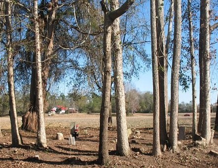
| Description | : | The cemetery is located on the old Brinson Place behind the house in back of a field. It's a small cemetery with at least 6 known graves there. Others are buried there as well unmarked. GPS N 34 00 589 - W 078 52 057. Starting from the address of 1835 Brinson Lane, Loris, SC, travel Brinson Lane toward the house. Just past the tree line of the driveway, there is a farm road on the left, take that road and travel toward the back left side of the property. |
frequently asked questions (FAQ):
-
Where is Brinson Family Cemetery?
Brinson Family Cemetery is located at Allsbrook, Horry County ,South Carolina ,USA.
-
Brinson Family Cemetery cemetery's updated grave count on graveviews.com?
0 memorials
-
Where are the coordinates of the Brinson Family Cemetery?
Latitude: 34.0098450
Longitude: -78.8678470
Nearby Cemetories:
1. Holly Hill Cemetery
Loris, Horry County, USA
Coordinate: 34.0121994, -78.8683014
2. Carter Cemetery
Loris, Horry County, USA
Coordinate: 33.9930992, -78.8555984
3. Cherry Hill Baptist Church Cemetery
Loris, Horry County, USA
Coordinate: 33.9907990, -78.8908005
4. Antioch Cemetery
Loris, Horry County, USA
Coordinate: 34.0104490, -78.8266900
5. Simpson Creek Primitive Baptist Church Cemetery
Loris, Horry County, USA
Coordinate: 33.9868520, -78.8366910
6. Mishoe Cemetery
Allsbrook, Horry County, USA
Coordinate: 33.9821000, -78.9000500
7. Patterson Cemetery
Loris, Horry County, USA
Coordinate: 34.0497017, -78.8902969
8. Mount Nebo Baptist Church Cemetery
Loris, Horry County, USA
Coordinate: 34.0359000, -78.8230000
9. Beulah Cemetery
Loris, Horry County, USA
Coordinate: 33.9675360, -78.8885110
10. Cushion Swamp Cemetery
Loris, Horry County, USA
Coordinate: 34.0445640, -78.9104840
11. Heavenly Hills Cemetery
Loris, Horry County, USA
Coordinate: 34.0518110, -78.8302340
12. Mount Rona Cemetery
Loris, Horry County, USA
Coordinate: 34.0478230, -78.8192980
13. Flag Patch Cemetery
Loris, Horry County, USA
Coordinate: 34.0449982, -78.8142014
14. Stevens Cemetery
Loris, Horry County, USA
Coordinate: 33.9949989, -78.9372025
15. Old Springfield Cemetery
Loris, Horry County, USA
Coordinate: 34.0527992, -78.8161011
16. Cane Branch Baptist Church Cemetery
Allsbrook, Horry County, USA
Coordinate: 34.0033280, -78.9407800
17. Hardee Cemetery
Loris, Horry County, USA
Coordinate: 33.9530983, -78.8261032
18. Thompson-Johnson Cemetery
Loris, Horry County, USA
Coordinate: 34.0299800, -78.7912500
19. Oak Dale Missionary Baptist Church Cemetery
Loris, Horry County, USA
Coordinate: 34.0696260, -78.8269070
20. William Mayo Hardee Cemetery
Loris, Horry County, USA
Coordinate: 34.0697800, -78.8265640
21. New Home Baptist Church Cemetery
Conway, Horry County, USA
Coordinate: 33.9627991, -78.9321976
22. Hughes Cemetery
Loris, Horry County, USA
Coordinate: 33.9432983, -78.8268967
23. Barnhill-Martin Cemetery
Loris, Horry County, USA
Coordinate: 33.9433070, -78.8264000
24. Creekside Cemetery
Loris, Horry County, USA
Coordinate: 33.9423890, -78.8263510