
| Memorials | : | 1 |
| Location | : | Kompromise, Namakwa District Municipality, South Africa |
| Coordinate | : | -31.9052670, 20.2307500 |
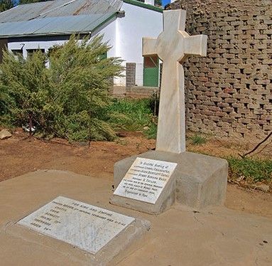
| Description | : | The tiny village of Middelpos is situated almost equidistant between Sutherland and Calvinia on the R354 and remains probably one of the most authentic Karoo villages in its isolation and remoteness. Behind the Middelpos Hotel is a well-tended memorial to the 11 Officers and men of the 11th Imperial Yeomanry who were killed in action on the 5th and 6th of February in 1902, during the Anglo Boer War. |
frequently asked questions (FAQ):
-
Where is British Anglo Boer War Memorial?
British Anglo Boer War Memorial is located at Hoofstraat 3 Kompromise, Namakwa District Municipality ,Northern Cape , 8193South Africa.
-
British Anglo Boer War Memorial cemetery's updated grave count on graveviews.com?
1 memorials
-
Where are the coordinates of the British Anglo Boer War Memorial?
Latitude: -31.9052670
Longitude: 20.2307500
Nearby Cemetories:
1. Hoogekraal Farm Cemetery
Calvinia, Namakwa District Municipality, South Africa
Coordinate: -31.4767098, 19.7783071
2. Calvinia Cemetery
Calvinia, Namakwa District Municipality, South Africa
Coordinate: -31.4761889, 19.7780932
3. Plessis Street Cemetery
Calvinia, Namakwa District Municipality, South Africa
Coordinate: -31.4705481, 19.7643484
4. Sutherland Anglo Boer War Cemetery
Sutherland, Namakwa District Municipality, South Africa
Coordinate: -32.3996470, 20.6582640
5. Sutherland Cemetery
Sutherland, Namakwa District Municipality, South Africa
Coordinate: -32.3992767, 20.6592312
6. Williston Municipal Cemetery
Central Karoo District Municipality, South Africa
Coordinate: -31.3521678, 20.9088723
7. Williston Cemetery
Williston, Namakwa District Municipality, South Africa
Coordinate: -31.3474721, 20.9063914
8. NG Kerk - Williston Kerkhof
Williston, Namakwa District Municipality, South Africa
Coordinate: -31.3409716, 20.9164241
9. Amandelboom Cemetery
Williston, Namakwa District Municipality, South Africa
Coordinate: -31.3423081, 20.9239760
10. Doringbos Cemetery
Cederberg, West Coast District Municipality, South Africa
Coordinate: -31.9750292, 19.2235993
11. Wupperthal
Wupperthal, West Coast District Municipality, South Africa
Coordinate: -32.2761252, 19.2180976
12. Sevilla 135 Cemetery
Clanwilliam, West Coast District Municipality, South Africa
Coordinate: -32.0661255, 19.1273011
13. Nieuwoudtville Cemetery
Nieuwoudtville, Namakwa District Municipality, South Africa
Coordinate: -31.3760996, 19.1272025
14. Fraserburg North Cemetery
Fraserburg, Namakwa District Municipality, South Africa
Coordinate: -31.8986190, 21.5153060
15. Spitsberg Farm Cemetery
Loeriesfontein, Namakwa District Municipality, South Africa
Coordinate: -30.9217100, 19.5529100
16. NG Kerk - Clanwilliam Kerkhof
Clanwilliam, West Coast District Municipality, South Africa
Coordinate: -32.1804460, 18.8933760
17. St John's Anglican Cemetery
Clanwilliam, West Coast District Municipality, South Africa
Coordinate: -32.1789010, 18.8928590
18. Windkloof Street Cemetery
Loeriesfontein, Namakwa District Municipality, South Africa
Coordinate: -30.9528469, 19.4319591
19. Loeriesfontein Old Cemetery
Loeriesfontein, Namakwa District Municipality, South Africa
Coordinate: -30.9476587, 19.4351083
20. Loeriesfontein Cemetery
Loeriesfontein, Namakwa District Municipality, South Africa
Coordinate: -30.9451000, 19.4386830
21. Modderfontein Cemetery
West Coast District Municipality, South Africa
Coordinate: -32.6060587, 18.9904084
22. Vanrhynsdorp North Cemetery
Vanrhynsdorp, West Coast District Municipality, South Africa
Coordinate: -31.5954406, 18.7571635
23. NG Kerk - Vanrhynsdorp Gedenkmuur
Vanrhynsdorp, West Coast District Municipality, South Africa
Coordinate: -31.6087299, 18.7369811
24. Vanrhynsdorp South Cemetery
Vanrhynsdorp, West Coast District Municipality, South Africa
Coordinate: -31.6130650, 18.7354200