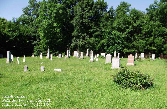
| Memorials | : | 9 |
| Location | : | Washington Township, Union County, USA |
| Coordinate | : | 40.4808006, -83.4111023 |
| Description | : | The cemetery is located about 1100 feet west of Cunningham Arabela Road (Township Road 340) about 0.3 miles west of its intersection with Ohio State Route 739. The cemetery is located in Washington Township, Union County, Ohio, and is # 12010 (Arabela Cemetery / Burnside Cemetery) in “Ohio Cemeteries 1803-2003”, compiled by the Ohio Genealogical Society. The U.S. Geological Survey (USGS) Geographic Names Information System (GNIS) feature ID for the cemetery is 1038543 (Burnside Cemetery). The Union County, Ohio GIS lists this cemetery as parcel no. 3500120360000 owned by Trustees Grace Chapel Cemetery. The parcel is 0.50... Read More |
frequently asked questions (FAQ):
-
Where is Burnside Cemetery?
Burnside Cemetery is located at Cunningham Arabela Road (Township Road 340) Washington Township, Union County ,Ohio , 43344USA.
-
Burnside Cemetery cemetery's updated grave count on graveviews.com?
9 memorials
-
Where are the coordinates of the Burnside Cemetery?
Latitude: 40.4808006
Longitude: -83.4111023
Nearby Cemetories:
1. Jackson Township Unidentified Cemetery #3
Jackson Township, Union County, USA
Coordinate: 40.4795030, -83.3913390
2. Schertzer Cemetery
Mount Victory, Hardin County, USA
Coordinate: 40.5175858, -83.4373856
3. East York Cemetery
York Center, Union County, USA
Coordinate: 40.4380989, -83.4002991
4. Byhalia Cemetery
Byhalia, Union County, USA
Coordinate: 40.4632988, -83.4672012
5. Fairview Cemetery
La Rue, Marion County, USA
Coordinate: 40.5347786, -83.3751984
6. Price Cemetery
Richwood, Union County, USA
Coordinate: 40.4949989, -83.3257980
7. Cheney Cemetery
Essex, Union County, USA
Coordinate: 40.4763985, -83.3202972
8. York Township Unidentified Cemetery #1
York Township, Union County, USA
Coordinate: 40.4106060, -83.4350610
9. Jackson Township Unidentified Cemetery #1
Jackson Township, Union County, USA
Coordinate: 40.4761390, -83.3140830
10. York Cemetery
York Center, Union County, USA
Coordinate: 40.4117200, -83.4543700
11. Guthery Cemetery
La Rue, Marion County, USA
Coordinate: 40.5466995, -83.3494034
12. Claibourne Township Unidentified Cemetery #1
Claibourne Township, Union County, USA
Coordinate: 40.4095250, -83.3597560
13. Somersville Cemetery
Richwood, Union County, USA
Coordinate: 40.3988000, -83.4141000
14. Hamilton Cemetery
Richwood, Union County, USA
Coordinate: 40.4406013, -83.3161011
15. Rush Creek Cemetery
Washington Township, Union County, USA
Coordinate: 40.4986000, -83.5192032
16. Jackson Township Unidentified Cemetery #2
Jackson Township, Union County, USA
Coordinate: 40.4930060, -83.3004750
17. Stony Point Cemetery
Claibourne Township, Union County, USA
Coordinate: 40.3985850, -83.3497440
18. York Township Unidentified Cemetery #3
York Township, Union County, USA
Coordinate: 40.3851360, -83.4055220
19. Bonner Cemetery
La Rue, Marion County, USA
Coordinate: 40.5758018, -83.3949966
20. Johnson Farm Cemetery
York Center, Union County, USA
Coordinate: 40.3851300, -83.4037600
21. Dille Cemetery
Mount Victory, Hardin County, USA
Coordinate: 40.5319995, -83.5179821
22. Mount Victory Cemetery
Hardin County, USA
Coordinate: 40.5320470, -83.5180480
23. Fisher Cemetery
Hardin County, USA
Coordinate: 40.5708008, -83.4664001
24. York Township Unidentified Cemetery #2
York Township, Union County, USA
Coordinate: 40.3798280, -83.4021580

