
| Memorials | : | 3 |
| Location | : | Knightsville, Dorchester County, USA |
| Coordinate | : | 32.9985657, -80.2307510 |
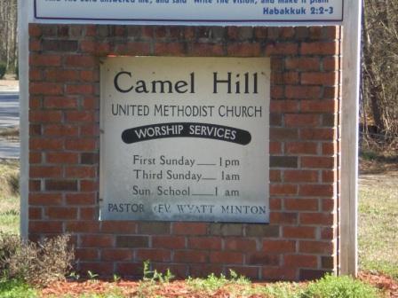
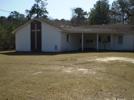
| Description | : | African American Cemetery Location: Traveling from Summerville, SC ... Where Highway 17A and Highway 78 cross, take 17A toward Walterboro SC, travel roughly 3.5 miles to Summerville Cemetery (on the right). Just as you pass the cemetery take the Knightville exit to the right. Travel three-quarters of a mile to the flashing light, turn right onto Old Orangeburg Road. The church is located one-quarter mile on the left, with the cemetery in back. Traveling from Walterboro, SC on 17A ... When you come to the red light at Highway 17A and Old Orangeburg Road turn left and continue one mile, with church on... Read More |
frequently asked questions (FAQ):
-
Where is Camel Hill United Methodist Church Cemetery?
Camel Hill United Methodist Church Cemetery is located at Knightsville, Dorchester County ,South Carolina ,USA.
-
Camel Hill United Methodist Church Cemetery cemetery's updated grave count on graveviews.com?
3 memorials
-
Where are the coordinates of the Camel Hill United Methodist Church Cemetery?
Latitude: 32.9985657
Longitude: -80.2307510
Nearby Cemetories:
1. Boone Hill United Methodist Church Cemetery
Summerville, Dorchester County, USA
Coordinate: 32.9981003, -80.2169037
2. Summerville Cemetery & Mausoleum
Summerville, Dorchester County, USA
Coordinate: 32.9988289, -80.2150040
3. Faith Baptist Church Cemetery
Jedburg, Dorchester County, USA
Coordinate: 32.9970920, -80.2534370
4. Saint Theresa Catholic Church Cemetery
Summerville, Dorchester County, USA
Coordinate: 32.9727490, -80.2388970
5. Dorchester Memory Gardens
Summerville, Dorchester County, USA
Coordinate: 32.9737358, -80.2440186
6. Saint Pauls Episcopal Church Cemetery
Summerville, Dorchester County, USA
Coordinate: 33.0136299, -80.1878815
7. Friendship True Bibleway Church Cemetery
Ridgeville, Dorchester County, USA
Coordinate: 33.0258150, -80.1960880
8. Murray United Methodist Church Cemetery
Knightsville, Dorchester County, USA
Coordinate: 33.0363083, -80.2469788
9. Brownsville Cemetery
Summerville, Dorchester County, USA
Coordinate: 33.0279510, -80.1962470
10. Old White Meeting House and Cemetery
Summerville, Dorchester County, USA
Coordinate: 32.9654500, -80.1943740
11. Salters Cemetery
Summerville, Dorchester County, USA
Coordinate: 32.9646988, -80.1947021
12. Smith Cemetery
Summerville, Dorchester County, USA
Coordinate: 32.9933390, -80.1760740
13. Colonial Dorchester State Park
Summerville, Dorchester County, USA
Coordinate: 32.9766113, -80.1811284
14. Bethany United Methodist Church Columbarium
Summerville, Dorchester County, USA
Coordinate: 33.0169810, -80.1790290
15. Saint Lukes Lutheran Church Columbarium
Dorchester County, USA
Coordinate: 33.0190990, -80.1800090
16. Old Fort Baptist Church Cemetery
Saint George, Dorchester County, USA
Coordinate: 32.9638630, -80.1906870
17. Ladson Family Burial Ground
Summerville, Dorchester County, USA
Coordinate: 32.9700230, -80.1838600
18. Hillcrest Cemetery
Charleston County, USA
Coordinate: 33.0100670, -80.1727524
19. Pine Hill Cemetery
Summerville, Dorchester County, USA
Coordinate: 33.0012020, -80.1684420
20. Dr. William Morgan Cemetery
Summerville, Dorchester County, USA
Coordinate: 32.9818649, -80.1707764
21. Pineland Cemetery
Summerville, Dorchester County, USA
Coordinate: 33.0118550, -80.1687390
22. Cook Family Cemetery
Summerville, Dorchester County, USA
Coordinate: 32.9495770, -80.1953520
23. Canaan United Methodist Church Cemetery
Givhans, Dorchester County, USA
Coordinate: 32.9644814, -80.2884293
24. New Bethel Sounds of Praise Church Cemetery
Summerville, Dorchester County, USA
Coordinate: 33.0544010, -80.2561050