
| Memorials | : | 147 |
| Location | : | King Island Council, Australia |
| Coordinate | : | -40.0304730, 143.8846350 |
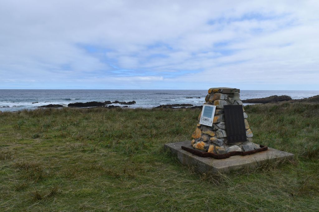
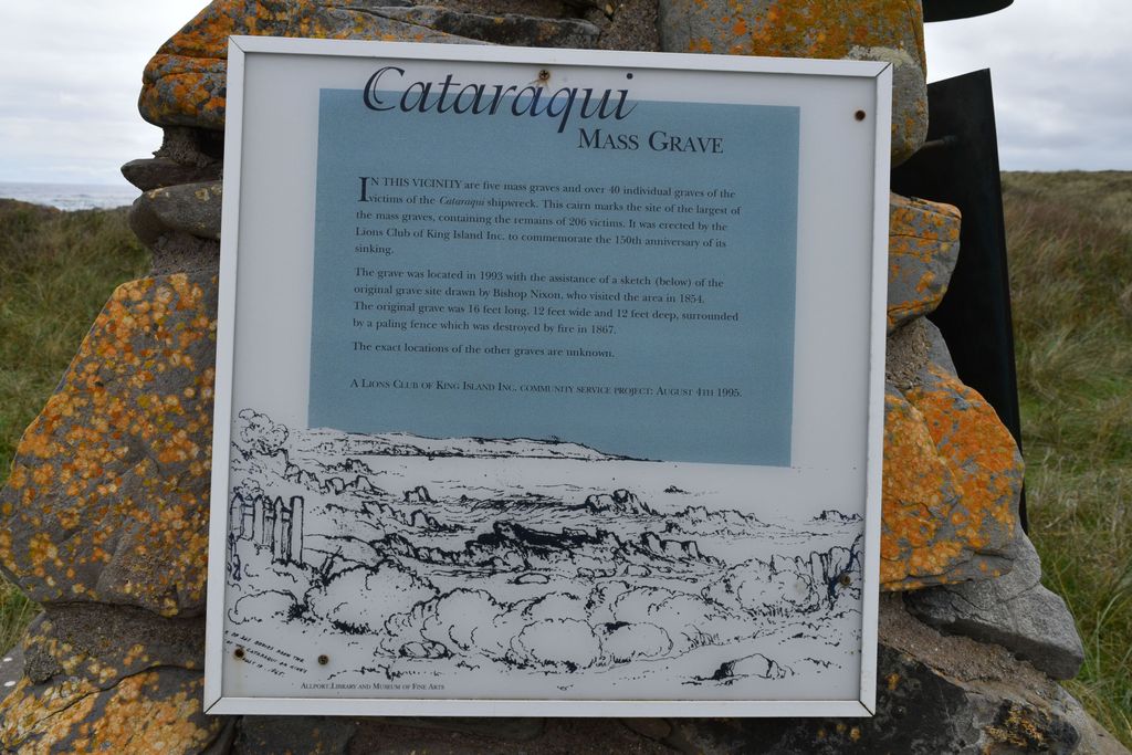
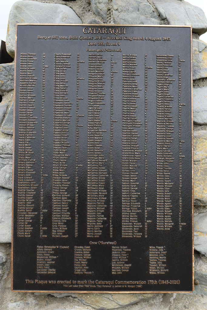
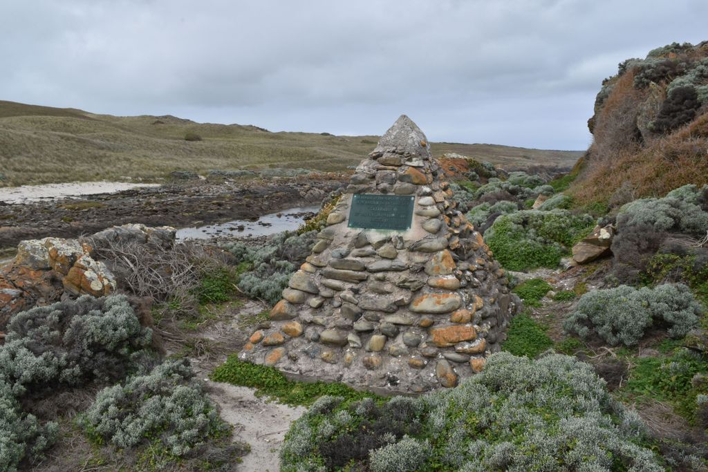
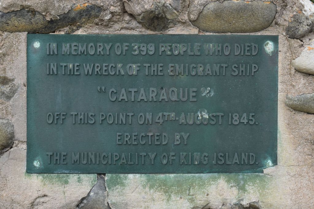
| Description | : | A total of 342 bodies, from the shipwrecked Cataraqui, were buried in five main graves, and several smaller graves. There are conflicting reports on the number of total lives lost; some records say 406, others 399. What is clear is that there were only 9 survivors: chief mate Thomas Gutherie, seven seamen and a lone passenger, Solomon Brown. The original cairn, cast in iron, was erected at the beach line in 1848 by the order of Governor La Trobe. It eventually rusted away and was replaced in 1956 by a stone cairn above the bluff. In 1995 the King Island community,... Read More |
frequently asked questions (FAQ):
-
Where is Cataraqui Shipwreck Memorial?
Cataraqui Shipwreck Memorial is located at Pearson Lane, Fitzmaurice Bay King Island Council ,Tasmania ,Australia.
-
Cataraqui Shipwreck Memorial cemetery's updated grave count on graveviews.com?
147 memorials
-
Where are the coordinates of the Cataraqui Shipwreck Memorial?
Latitude: -40.0304730
Longitude: 143.8846350
Nearby Cemetories:
1. Seal Rocks Road
King Island Council, Australia
Coordinate: -40.1132760, 143.9129680
2. King Island Cemetery
Currie, King Island Council, Australia
Coordinate: -39.9339200, 143.8551200
3. King Island Pioneer Graves
Currie, King Island Council, Australia
Coordinate: -39.9289320, 143.8468050
4. Marrawah Cemetery
Marrawah, Circular Head Council, Australia
Coordinate: -40.9142600, 144.6805400
5. Montagu Cemetery
Montagu, Circular Head Council, Australia
Coordinate: -40.7732220, 144.9512260
6. Montagu Roman Catholic Cemetery
Montagu, Circular Head Council, Australia
Coordinate: -40.7599010, 144.9733950
7. Montagu Gospel Hall Cemetery
Montagu, Circular Head Council, Australia
Coordinate: -40.7769360, 144.9540140
8. Cape Otway Cemetery
Cape Otway, Colac Otway Shire, Australia
Coordinate: -38.8560000, 143.5120000
9. Smithton Cemetery
Smithton, Circular Head Council, Australia
Coordinate: -40.8515000, 145.1289900
10. Smithton Scotchtown Road Cemetery
Smithton, Circular Head Council, Australia
Coordinate: -40.8669080, 145.1153400
11. Apollo Bay Cemetery
Apollo Bay, Colac Otway Shire, Australia
Coordinate: -38.7798480, 143.6596290
12. Irishtown Public Cemetery
Irishtown, Circular Head Council, Australia
Coordinate: -40.8976100, 145.1447000
13. Ollington Cemetery
Forest, Circular Head Council, Australia
Coordinate: -40.8290500, 145.2262070
14. Circular Head Lawn Cemetery
Stanley, Circular Head Council, Australia
Coordinate: -40.8141700, 145.2432500
15. Stanley Burial Ground
Stanley, Circular Head Council, Australia
Coordinate: -40.7594770, 145.2984500
16. St. Bartholomew's Anglican Cemetery
Forest, Circular Head Council, Australia
Coordinate: -40.8553130, 145.2469170
17. Moonlight Head Cemetery
Princetown, Corangamite Shire, Australia
Coordinate: -38.7528800, 143.2250500
18. Rocky Cape Cemetery
Rocky Cape, Circular Head Council, Australia
Coordinate: -40.8948900, 145.4608770
19. Lorne Cemetery
Lorne, Surf Coast Shire, Australia
Coordinate: -38.5280000, 143.9778000
20. Yaugher Cemetery
Yaugher, Colac Otway Shire, Australia
Coordinate: -38.4982530, 143.7203200
21. Loch Ard Cemetery
Port Campbell, Corangamite Shire, Australia
Coordinate: -38.6306560, 143.0321530
22. Port Campbell Cemetery
Port Campbell, Corangamite Shire, Australia
Coordinate: -38.6132610, 143.0005630
23. Angahook Cemetery
Anglesea, Surf Coast Shire, Australia
Coordinate: -38.4190540, 144.1306770
24. Bambra Cemetery
Deans Marsh, Surf Coast Shire, Australia
Coordinate: -38.3903790, 143.9147800