
| Memorials | : | 9 |
| Location | : | Columbia, Richland County, USA |
| Coordinate | : | 33.9586540, -80.9856960 |
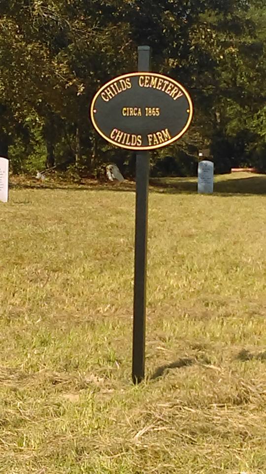
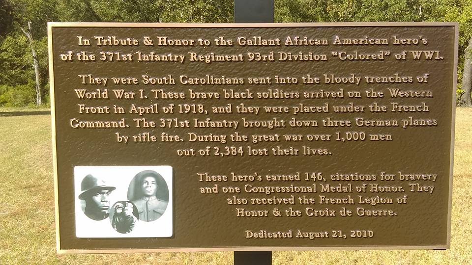
| Description | : | Cemetery is located on land currently owned by Interstate Polymer Group. The cemetery is behind the plant and is divided by a railroad spur, so it extends onto the right-of-way of the Norfolk Southern Railroad. The cemetery was originally a slave cemetery on the grounds of a plantation owned by Confederate General Wade Hampton. After the Civil War, the property was purchased by the Childs Family and the cemetery was used by a pair of churches and several local black communities. After the land was purchased for commercial use, the cemetery was not maintained. In 2009, Sonya Hodges began a project to... Read More |
frequently asked questions (FAQ):
-
Where is Childs Cemetery?
Childs Cemetery is located at S. Beltline Blvd at Shop Rd Columbia, Richland County ,South Carolina ,USA.
-
Childs Cemetery cemetery's updated grave count on graveviews.com?
9 memorials
-
Where are the coordinates of the Childs Cemetery?
Latitude: 33.9586540
Longitude: -80.9856960
Nearby Cemetories:
1. Brown Chapel AME Church Cemetery
Columbia, Richland County, USA
Coordinate: 33.9594420, -81.0033920
2. Second Union Baptist Church Cemetery
Columbia, Richland County, USA
Coordinate: 33.9760290, -81.0114460
3. USC Medical School Memorial Garden
Richland County, USA
Coordinate: 33.9791700, -80.9609000
4. Greenlawn Memorial Park
Columbia, Richland County, USA
Coordinate: 33.9733009, -80.9505997
5. Saint Joseph Catholic Church Columbarium
Columbia, Richland County, USA
Coordinate: 33.9962370, -80.9899740
6. Greenlawn Serenity Gardens
Columbia, Richland County, USA
Coordinate: 33.9821580, -80.9498730
7. Saint Johns Episcopal Church Memorial Garden
Columbia, Richland County, USA
Coordinate: 33.9954500, -81.0015100
8. Lutheran Church of the Incarnation
Richland County, USA
Coordinate: 33.9979650, -80.9987080
9. Olympia Cemetery
Columbia, Richland County, USA
Coordinate: 33.9719009, -81.0325012
10. Kelly Cemetery
Columbia, Richland County, USA
Coordinate: 34.0048619, -80.9682217
11. Eastminster Presbyterian Church Columbarium
Columbia, Richland County, USA
Coordinate: 34.0079530, -80.9942360
12. J. E. Belser Cemetery
Columbia, Richland County, USA
Coordinate: 34.0050190, -80.9533680
13. Old Gilmore Cemetery
Columbia, Richland County, USA
Coordinate: 33.9683140, -80.9188390
14. Saint Lukes Episcopal Church Memorial Garden
Columbia, Richland County, USA
Coordinate: 34.0082060, -81.0180940
15. Gillmore Family Cemetery
Hopkins, Richland County, USA
Coordinate: 33.9682440, -80.9187130
16. Mill Creek AME Church Cemetery
Lykes, Richland County, USA
Coordinate: 33.9371470, -80.9227220
17. First Presbyterian Churchyard
Columbia, Richland County, USA
Coordinate: 34.0041110, -81.0293900
18. Old Sweet Home Church Cemetery
Columbia, Richland County, USA
Coordinate: 33.9831630, -80.9217350
19. Saint Martins in the Fields Memorial Garden
Forest Acres, Richland County, USA
Coordinate: 34.0170120, -80.9719390
20. Taylor Cemetery
Cayce, Lexington County, USA
Coordinate: 33.9661380, -81.0570790
21. Arthur Cemetery
Cayce, Lexington County, USA
Coordinate: 33.9666730, -81.0573280
22. Zion Mill Creek Baptist Church Cemetery
Lykes, Richland County, USA
Coordinate: 33.9436450, -80.9152510
23. Mill Creek UMC Cemetery
Columbia, Richland County, USA
Coordinate: 33.9494800, -80.9130100
24. First Baptist Church Cemetery
Columbia, Richland County, USA
Coordinate: 34.0062460, -81.0321850