
| Memorials | : | 2 |
| Location | : | Center Township, Morgan County, USA |
| Coordinate | : | 39.6039470, -81.6137010 |
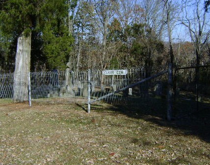
| Description | : | The cemetery is located about 250 feet west of Tip Lane (Township Road 328) about 0.25 miles west of its intersection with Stony Run Road (Township Road 242). The cemetery is located in Center Township, Morgan County, Ohio, and is # 8462 (Endicott Cemetery / Clark Cemetery) in “Ohio Cemeteries 1803-2003”, compiled by the Ohio Genealogical Society. The U.S. Geological Survey (USGS) Geographic Names Information System (GNIS) feature ID for the cemetery is 1071006 (Clark Cemetery / Endicott Cemetery). |
frequently asked questions (FAQ):
-
Where is Clark Cemetery?
Clark Cemetery is located at Tip Lane (Township Road 328) Center Township, Morgan County ,Ohio , 45715USA.
-
Clark Cemetery cemetery's updated grave count on graveviews.com?
2 memorials
-
Where are the coordinates of the Clark Cemetery?
Latitude: 39.6039470
Longitude: -81.6137010
Nearby Cemetories:
1. Boyd Cemetery
Center Township, Morgan County, USA
Coordinate: 39.6075860, -81.6123530
2. Mount Olive Cemetery
Center Township, Morgan County, USA
Coordinate: 39.6136900, -81.6254400
3. Burrows Cemetery
Center Township, Morgan County, USA
Coordinate: 39.5872002, -81.5950012
4. Ludlow Cemetery
Center Township, Morgan County, USA
Coordinate: 39.5908320, -81.6553280
5. Payne Cemetery
Center Township, Morgan County, USA
Coordinate: 39.6391983, -81.6006012
6. Hughes Cemetery
Centerville, Morgan County, USA
Coordinate: 39.6438900, -81.6015957
7. Smiths Chapel Cemetery
Center Township, Morgan County, USA
Coordinate: 39.6227989, -81.6611023
8. Mason Cemetery
Coal Run, Washington County, USA
Coordinate: 39.5676350, -81.5852910
9. Centerville Cemetery
Centerville, Morgan County, USA
Coordinate: 39.6458015, -81.6271973
10. Jordan Cemetery
Center Township, Morgan County, USA
Coordinate: 39.6439018, -81.5883026
11. Phillis Cemetery
Center Township, Morgan County, USA
Coordinate: 39.6536210, -81.6086880
12. Carrel Cemetery
Noble County, USA
Coordinate: 39.6361008, -81.5627975
13. Devol Cemetery
Coal Run, Washington County, USA
Coordinate: 39.5602989, -81.5796967
14. Williamson Cemetery
Dungannon, Noble County, USA
Coordinate: 39.6264000, -81.5531006
15. DeLong Cemetery
Relief, Washington County, USA
Coordinate: 39.5833015, -81.6755981
16. Saint Bernard Cemetery
Beverly, Washington County, USA
Coordinate: 39.5533730, -81.6304510
17. Beverly Cemetery
Beverly, Washington County, USA
Coordinate: 39.5527992, -81.6316833
18. Round Bottom Cemetery
Coal Run, Washington County, USA
Coordinate: 39.5548500, -81.5864500
19. Sprague Cemetery
Coal Run, Washington County, USA
Coordinate: 39.5598750, -81.5722430
20. Morris Cemetery
Center Township, Morgan County, USA
Coordinate: 39.6582985, -81.6055984
21. Jordan Cemetery
Caldwell, Noble County, USA
Coordinate: 39.6434850, -81.5622960
22. Saint Margaret Cemetery
Reinersville, Morgan County, USA
Coordinate: 39.6335983, -81.6781006
23. Swickard Cemetery
Center Township, Morgan County, USA
Coordinate: 39.6617012, -81.6106033
24. Saint Elizabeths Catholic Cemetery
Hackney, Morgan County, USA
Coordinate: 39.6367280, -81.6804160