
| Memorials | : | 6 |
| Location | : | Roane County, USA |
| Coordinate | : | 38.6278000, -81.3414001 |
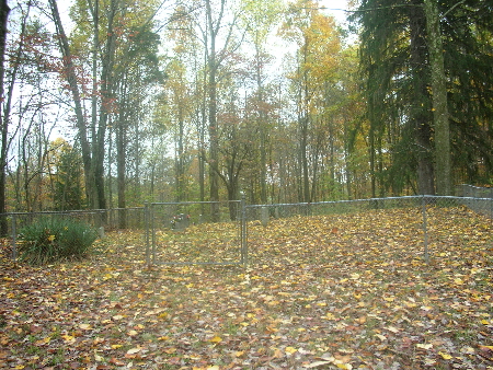
| Description | : | Coordinates: Latitude 38'37.683; Longitude -081'20.458 WPA Reading 12/12/1938: 6.5 mi E. of Walton on Johnson Creek Rd., Mack Kelly farm. Established 1891 as a family burial ground; extent, 1/2 a.; no restrictions as to type and placing of markers; fenced; not landscaped; condition, good. Lots not marked, graves marked by monuments and field stones; lots not for sale; no burial records kept; still in use as burial ground. Earliest stone dated 1891. Marked graves, 7; unmarked graves, 10. This reading from pictures I took & compared with WPA Reading; I walked this cemetery 10/2007 &... Read More |
frequently asked questions (FAQ):
-
Where is Claudius Peter Kelly Cemetery?
Claudius Peter Kelly Cemetery is located at Roane County ,West Virginia ,USA.
-
Claudius Peter Kelly Cemetery cemetery's updated grave count on graveviews.com?
6 memorials
-
Where are the coordinates of the Claudius Peter Kelly Cemetery?
Latitude: 38.6278000
Longitude: -81.3414001
Nearby Cemetories:
1. Kelly Cemetery
Roane County, USA
Coordinate: 38.6291160, -81.3411160
2. Deverick Cemetery
Roane County, USA
Coordinate: 38.6446991, -81.3311005
3. Jones Cemetery
Roane County, USA
Coordinate: 38.6074982, -81.3455963
4. J. Herbert Smith Sr. Cemetery
Roane County, USA
Coordinate: 38.6109380, -81.3227570
5. Gandee Cemetery
Roane County, USA
Coordinate: 38.6049995, -81.3249969
6. Hively Cemetery #2
Roane County, USA
Coordinate: 38.6161003, -81.3728027
7. Jackson Cemetery
Roane County, USA
Coordinate: 38.6138992, -81.3067017
8. Daugherty Cemetery
Roane County, USA
Coordinate: 38.6492880, -81.3113970
9. Hershberger Cemetery
Roane County, USA
Coordinate: 38.6150017, -81.2996979
10. Jones Cemetery
Roane County, USA
Coordinate: 38.5929700, -81.3559900
11. Kelley Cemetery
Roane County, USA
Coordinate: 38.6385994, -81.2947006
12. Groves Cemetery
Roane County, USA
Coordinate: 38.6123560, -81.2968860
13. George Groves Cemetery
Left Hand, Roane County, USA
Coordinate: 38.6083861, -81.2963389
14. Groves Cemetery
Roane County, USA
Coordinate: 38.6081000, -81.2964000
15. Hascue Cemetery
Roane County, USA
Coordinate: 38.6552700, -81.3029800
16. Holbert Cemetery
Cotton, Roane County, USA
Coordinate: 38.5878900, -81.3312500
17. Cromwell Cemetery
Roane County, USA
Coordinate: 38.5993996, -81.3816986
18. Criner Cemetery
Roane County, USA
Coordinate: 38.6321983, -81.2861023
19. Barnhouse Cemetery
Roane County, USA
Coordinate: 38.5842018, -81.3375015
20. Bird Cemetery
Roane County, USA
Coordinate: 38.5868988, -81.3644028
21. Green Cemetery
Roane County, USA
Coordinate: 38.5839005, -81.3747025
22. Payne Cemetery
Clio, Roane County, USA
Coordinate: 38.5891991, -81.2957993
23. Hall Cemetery
Roane County, USA
Coordinate: 38.6426680, -81.2733580
24. Harper Cemetery
Cotton, Roane County, USA
Coordinate: 38.5703600, -81.3441800