
| Memorials | : | 0 |
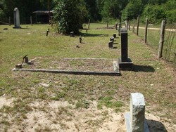
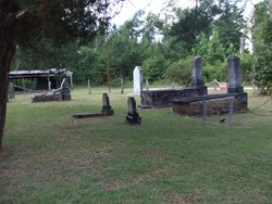
| Location | : | McHenry, Stone County, USA |
| Coordinate | : | 30.6770390, -89.1748910 |
| Description | : | From Wiggins Ms. Take Hy 49 South to McHenry Ms. then turn west on West McHenry Road to the top of the hill. Turn South on Old Hy 49 and cross the railroad track and then turn west on Riceville Rd about 4 miles the pavement ends. you cross a bridge and gravel begins, take the 1st road to the left and the cemetery is at the end of the road. |
frequently asked questions (FAQ):
-
Where is Col. John Bond Cemetery?
Col. John Bond Cemetery is located at McHenry, Stone County ,Mississippi ,USA.
-
Col. John Bond Cemetery cemetery's updated grave count on graveviews.com?
0 memorials
-
Where are the coordinates of the Col. John Bond Cemetery?
Latitude: 30.6770390
Longitude: -89.1748910
Nearby Cemetories:
1. Bond Cemetery
Saucier, Harrison County, USA
Coordinate: 30.6763992, -89.1746979
2. Diamond Cemetery
Saucier, Harrison County, USA
Coordinate: 30.6662445, -89.1777496
3. D C Wedgeworth Cemetery
Saucier, Harrison County, USA
Coordinate: 30.6583004, -89.2003021
4. Doss Wedgeworth Cemetery
Saucier, Harrison County, USA
Coordinate: 30.6410999, -89.1791992
5. Barney Hickman Cemetery
Saucier, Harrison County, USA
Coordinate: 30.6683598, -89.2245026
6. Greene-Mercer Cemetery
Saucier, Harrison County, USA
Coordinate: 30.6472140, -89.1375360
7. Oaklawn Cemetery
McHenry, Stone County, USA
Coordinate: 30.7150002, -89.1438980
8. Williams-Bond Cemetery
McHenry, Stone County, USA
Coordinate: 30.7223870, -89.1602550
9. McHenry Gardens Cemetery
McHenry, Stone County, USA
Coordinate: 30.7206001, -89.1530991
10. Noll Johnson Memorial Gardens
Saucier, Harrison County, USA
Coordinate: 30.6389008, -89.1322021
11. Perryville Baptist Church Cemetery
McHenry, Stone County, USA
Coordinate: 30.7221690, -89.1371180
12. Saucier Cemetery
Saucier, Harrison County, USA
Coordinate: 30.6324997, -89.1333008
13. Wedgeworth Cemetery
Saucier, Harrison County, USA
Coordinate: 30.6131001, -89.1671982
14. Pleasant Hill Baptist Church Cemetery
Saucier, Harrison County, USA
Coordinate: 30.6221310, -89.1331290
15. Blum Family Cemetery
Saucier, Harrison County, USA
Coordinate: 30.6109880, -89.1588680
16. Broadus Cemetery
Saucier, Harrison County, USA
Coordinate: 30.6471996, -89.1044006
17. Armes Road Cemetery
Saucier, Harrison County, USA
Coordinate: 30.6104736, -89.1588135
18. Hickman Cemetery
Stone County, USA
Coordinate: 30.7399998, -89.2067032
19. Dye Cemetery
Saucier, Harrison County, USA
Coordinate: 30.6044006, -89.1753006
20. Galilee Church Cemetery
Saucier, Harrison County, USA
Coordinate: 30.6102009, -89.2228012
21. Larry E. Wedgeworth Cemetery
Saucier, Harrison County, USA
Coordinate: 30.6031835, -89.1347366
22. Biloxi Creek Cemetery
McHenry, Stone County, USA
Coordinate: 30.7332039, -89.2516403
23. Bond-Saucier Cemetery
Ten Mile, Stone County, USA
Coordinate: 30.7316670, -89.2564440
24. Davis Hickman Perkins Cemetery
Perkinston, Stone County, USA
Coordinate: 30.7656002, -89.1567001