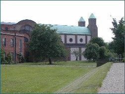
| Memorials | : | 0 |
| Location | : | Mirfield, Metropolitan Borough of Kirklees, England |
| Coordinate | : | 53.6832220, -1.7145200 |
frequently asked questions (FAQ):
-
Where is Community of the Resurrection Monastery Cemetery?
Community of the Resurrection Monastery Cemetery is located at 109 Stocks Bank Road Mirfield, Metropolitan Borough of Kirklees ,West Yorkshire , WF14 9QTEngland.
-
Community of the Resurrection Monastery Cemetery cemetery's updated grave count on graveviews.com?
0 memorials
-
Where are the coordinates of the Community of the Resurrection Monastery Cemetery?
Latitude: 53.6832220
Longitude: -1.7145200
Nearby Cemetories:
1. Christ the King Churchyard
Battyeford, Metropolitan Borough of Kirklees, England
Coordinate: 53.6842950, -1.7147120
2. Zion Baptist Chapelyard
Mirfield, Metropolitan Borough of Kirklees, England
Coordinate: 53.6824050, -1.6971930
3. Kirklees Priory
Kirklees, Metropolitan Borough of Kirklees, England
Coordinate: 53.6895330, -1.7376730
4. St Thomas Churchyard
Huddersfield, Metropolitan Borough of Kirklees, England
Coordinate: 53.6776200, -1.7401200
5. All Saints Churchyard
Roberttown, Metropolitan Borough of Kirklees, England
Coordinate: 53.7000600, -1.7070400
6. Hopton United Reformed Chapelyard
Mirfield, Metropolitan Borough of Kirklees, England
Coordinate: 53.6693460, -1.6959310
7. St Mary the Virgin Churchyard
Mirfield, Metropolitan Borough of Kirklees, England
Coordinate: 53.6798510, -1.6812410
8. St John the Evangelist Churchyard
Mirfield, Metropolitan Borough of Kirklees, England
Coordinate: 53.6627400, -1.7034200
9. Liversedge Cemetery
Liversedge, Metropolitan Borough of Kirklees, England
Coordinate: 53.7060590, -1.7146870
10. St. Peter's Churchyard
Hartshead Moorside, Metropolitan Borough of Kirklees, England
Coordinate: 53.7058900, -1.7303130
11. Deighton Methodist Chapelyard
Huddersfield, Metropolitan Borough of Kirklees, England
Coordinate: 53.6711800, -1.7518600
12. Deighton Methodist Chapelyard Extension Cemetery
Huddersfield, Metropolitan Borough of Kirklees, England
Coordinate: 53.6705000, -1.7519300
13. The Sepulchre Quaker Burial Ground
Liversedge, Metropolitan Borough of Kirklees, England
Coordinate: 53.7080290, -1.7258720
14. Christ Church Churchyard
Liversedge, Metropolitan Borough of Kirklees, England
Coordinate: 53.7119620, -1.6944580
15. Kirkheaton Cemetery
Kirkheaton, Metropolitan Borough of Kirklees, England
Coordinate: 53.6523100, -1.7228500
16. St John Churchyard
Clifton, Metropolitan Borough of Calderdale, England
Coordinate: 53.7018610, -1.7572600
17. Westgate Congregational Chapelyard
Heckmondwike, Metropolitan Borough of Kirklees, England
Coordinate: 53.7089400, -1.6819700
18. Clifton Cemetery
Clifton, Metropolitan Borough of Calderdale, England
Coordinate: 53.7022640, -1.7583680
19. St John the Baptist Churchyard
Kirkheaton, Metropolitan Borough of Kirklees, England
Coordinate: 53.6508510, -1.7309650
20. Quaker Meeting House
Liversedge, Metropolitan Borough of Kirklees, England
Coordinate: 53.7181500, -1.7147900
21. St James Churchyard
Heckmondwike, Metropolitan Borough of Kirklees, England
Coordinate: 53.7067190, -1.6703450
22. Christ Church Woodhouse
Huddersfield, Metropolitan Borough of Kirklees, England
Coordinate: 53.6677310, -1.7694960
23. Christ Church Churchyard
Fartown, Metropolitan Borough of Kirklees, England
Coordinate: 53.6675400, -1.7694500
24. Dewsbury Moor Crematorium
Dewsbury, Metropolitan Borough of Kirklees, England
Coordinate: 53.6899830, -1.6537470

