
| Memorials | : | 2 |
| Location | : | Lindytown, Boone County, USA |
| Coordinate | : | 37.8961200, -81.6144100 |
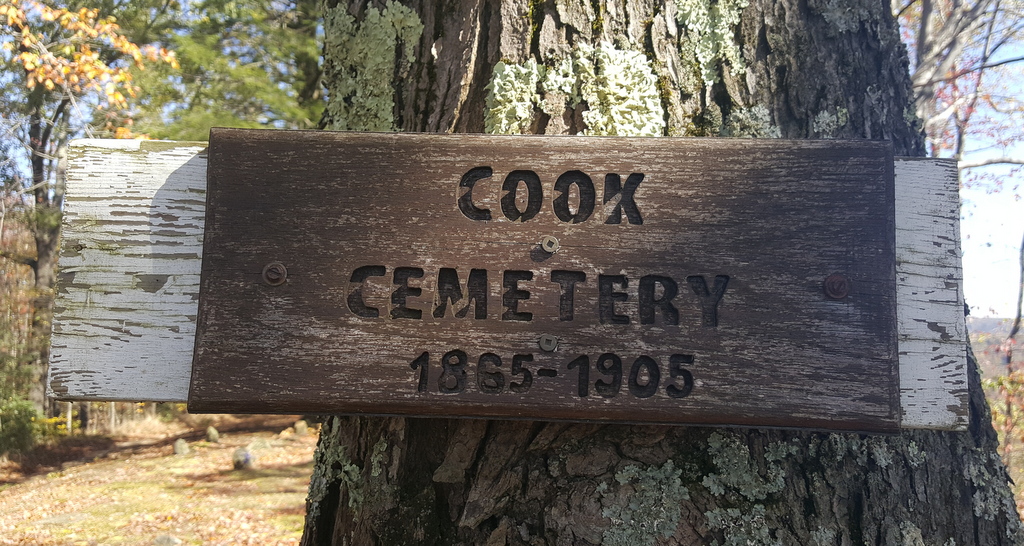
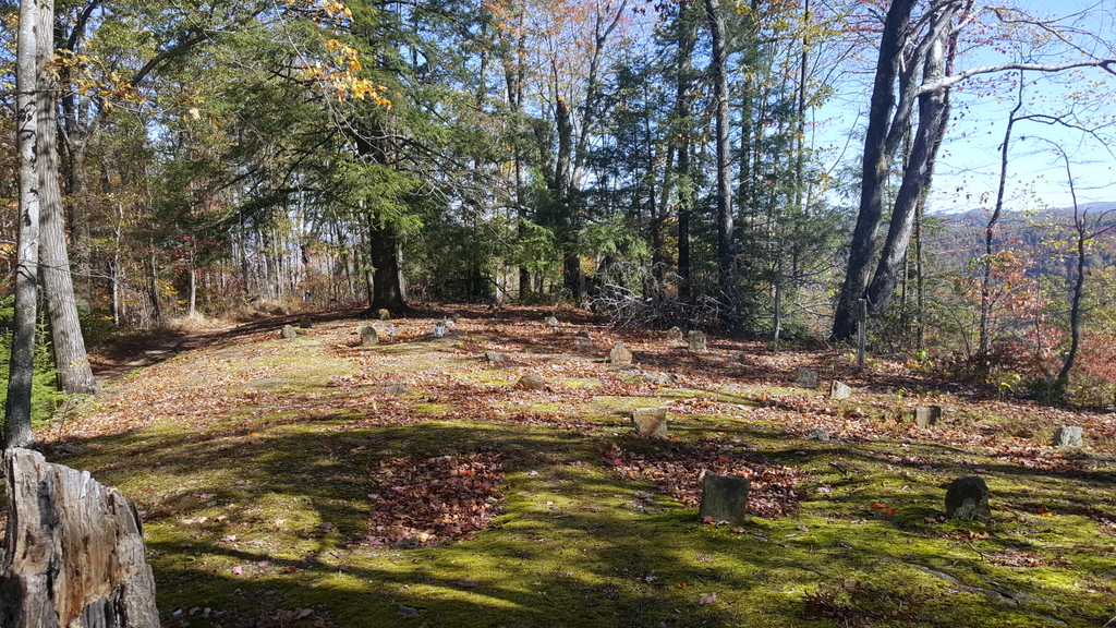
| Description | : | Located on Cook Mountain (Bald Knob); access past Twilight on Pond Fork. Travel to Lindytown, cross bridge, bear left then right, and follow gravel road to top of the mountain, now an inactive strip mine. There were three graveyards found on this mountain. This cemetery is in a copse of trees visible to the left with approximately 25 graves, mostly unmarked or illegible. The sign says 1865-1905, but Mary Catherine Walker Cook was buried here in 1861, and probably some of her children before that year. The second cemetery (Cook Mountain #2) has 2 obvious stones approximately 50 yards... Read More |
frequently asked questions (FAQ):
-
Where is Cook Mountain Cemetery?
Cook Mountain Cemetery is located at Cook Mountain Lindytown, Boone County ,West Virginia ,USA.
-
Cook Mountain Cemetery cemetery's updated grave count on graveviews.com?
2 memorials
-
Where are the coordinates of the Cook Mountain Cemetery?
Latitude: 37.8961200
Longitude: -81.6144100
Nearby Cemetories:
1. Lewis Jarrell Cemetery
Boone County, USA
Coordinate: 37.9077988, -81.5942001
2. Jarrells Branch Cemetery
Bald Knob, Boone County, USA
Coordinate: 37.8763870, -81.6420740
3. Old Workman Cemetery
Bald Knob, Boone County, USA
Coordinate: 37.8656777, -81.6383830
4. Jasper Workman Cemetery
Bald Knob, Boone County, USA
Coordinate: 37.8659400, -81.6395300
5. Hatfield Cemetery
Barrett, Boone County, USA
Coordinate: 37.8866200, -81.6640900
6. Bailey Cemetery
Boone County, USA
Coordinate: 37.8830986, -81.5633011
7. Asbury Cemetery
Boone County, USA
Coordinate: 37.8967018, -81.5597000
8. Green Cemetery
Bandytown, Boone County, USA
Coordinate: 37.9414810, -81.6420470
9. Jarrells Cemetery
Raleigh County, USA
Coordinate: 37.9272003, -81.5500031
10. Mid Ferrell Cemetery
Bandytown, Boone County, USA
Coordinate: 37.9491997, -81.6530991
11. Edwight Cemetery
Raleigh County, USA
Coordinate: 37.8820350, -81.5361500
12. Asbury Cemetery
Boone County, USA
Coordinate: 37.9144096, -81.5370941
13. Absolom Pettry Cemetery
Edwight, Raleigh County, USA
Coordinate: 37.8832200, -81.5345200
14. Noah White Cemetery
Bim, Boone County, USA
Coordinate: 37.9296430, -81.6978040
15. Harvey-Toler Cemetery
Boone County, USA
Coordinate: 37.8043840, -81.5716680
16. Daniels Cemetery
Logan County, USA
Coordinate: 37.7974450, -81.6295810
17. Stark Cemetery
Clothier, Boone County, USA
Coordinate: 37.9120130, -81.7435540
18. Whites Branch Cemetery
Gordon, Boone County, USA
Coordinate: 37.9769630, -81.7006530
19. Jarrell Cemetery
Raleigh County, USA
Coordinate: 37.8863983, -81.4772034
20. Peach Tree Road Family Cemetery
Dry Creek, Raleigh County, USA
Coordinate: 37.8550700, -81.4777200
21. Don Jarrell Cemetery
Dry Creek, Raleigh County, USA
Coordinate: 37.8622500, -81.4737900
22. Barrett Cemetery
Dry Creek, Raleigh County, USA
Coordinate: 37.8630400, -81.4641700
23. Daniel Family Cemetery
Dry Creek, Raleigh County, USA
Coordinate: 37.8625300, -81.4643300
24. Ballard Family Cemetery
Dry Creek, Raleigh County, USA
Coordinate: 37.8607920, -81.4612450