
| Memorials | : | 10 |
| Location | : | Pleasant Valley, Preston County, USA |
| Coordinate | : | 39.6032830, -79.7111870 |
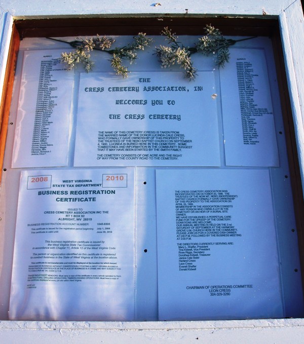
| Description | : | Located in Pleasant District on a hill behind the Mt. Nebo Baptist Church at the junction of Co.Routes 15 & 14. The name of this cemetery is taken from the married name of the donor, Lucinda Cale Cress, who formally gave ownership of the property in 1900. |
frequently asked questions (FAQ):
-
Where is Cress Cemetery?
Cress Cemetery is located at Pleasant Valley, Preston County ,West Virginia ,USA.
-
Cress Cemetery cemetery's updated grave count on graveviews.com?
10 memorials
-
Where are the coordinates of the Cress Cemetery?
Latitude: 39.6032830
Longitude: -79.7111870
Nearby Cemetories:
1. Jenkins Cemetery
Mount Nebo, Preston County, USA
Coordinate: 39.5925610, -79.7216120
2. Everly Cemetery
Mount Nebo, Preston County, USA
Coordinate: 39.5846641, -79.7148391
3. Protzman Cemetery
Preston County, USA
Coordinate: 39.5699680, -79.6782590
4. Fairview Cemetery
Pisgah, Preston County, USA
Coordinate: 39.6474991, -79.7378006
5. Walls Cemetery
Pisgah, Preston County, USA
Coordinate: 39.6361550, -79.7612190
6. Pleasant Grove Cemetery
Herring, Preston County, USA
Coordinate: 39.5438309, -79.7385101
7. Beech Run Cemetery
Preston County, USA
Coordinate: 39.5452995, -79.6641998
8. Everly Cemetery
Laurel Run, Preston County, USA
Coordinate: 39.6725722, -79.7048876
9. Ringer Cemetery
Bruceton Mills, Preston County, USA
Coordinate: 39.6175680, -79.6206020
10. Wesley Chapel Cemetery
Pleasantdale, Preston County, USA
Coordinate: 39.5260600, -79.7239100
11. Centenary Cemetery
Cuzzart, Preston County, USA
Coordinate: 39.6000920, -79.6036560
12. Sugar Valley Cemetery
Bruceton Mills, Preston County, USA
Coordinate: 39.6665993, -79.6404037
13. Bruceton Mills Cemetery
Bruceton Mills, Preston County, USA
Coordinate: 39.6666100, -79.6402150
14. Masontown Cemetery
Masontown, Preston County, USA
Coordinate: 39.5492220, -79.7985150
15. Pleasantdale Cemetery
Pleasantdale, Preston County, USA
Coordinate: 39.5179330, -79.6810740
16. Pell Cemetery
Kingwood, Preston County, USA
Coordinate: 39.5179330, -79.6810740
17. Shay and Elliott Cemetery
Pleasantdale, Preston County, USA
Coordinate: 39.5142731, -79.6711174
18. Brandonville Cemetery
Brandonville, Preston County, USA
Coordinate: 39.6667400, -79.6193100
19. Mountain Grove Church of the Brethren Cemetery
Laurel Run, Preston County, USA
Coordinate: 39.7003564, -79.6989387
20. White Family Cemetery
Pleasantdale, Preston County, USA
Coordinate: 39.5057450, -79.6908330
21. Lenox Memorial Cemetery
Lenox, Preston County, USA
Coordinate: 39.5597000, -79.5927963
22. Shaw Cemetery
Albright, Preston County, USA
Coordinate: 39.5221760, -79.6277860
23. Saint Peters Lutheran Cemetery
Clifton Mills, Preston County, USA
Coordinate: 39.7035860, -79.6691010
24. Shrout Cemetery
Pleasantdale, Preston County, USA
Coordinate: 39.4977460, -79.6769662