
| Memorials | : | 0 |
| Location | : | Calhoun County, USA |
| Coordinate | : | 39.3517820, -90.6552560 |
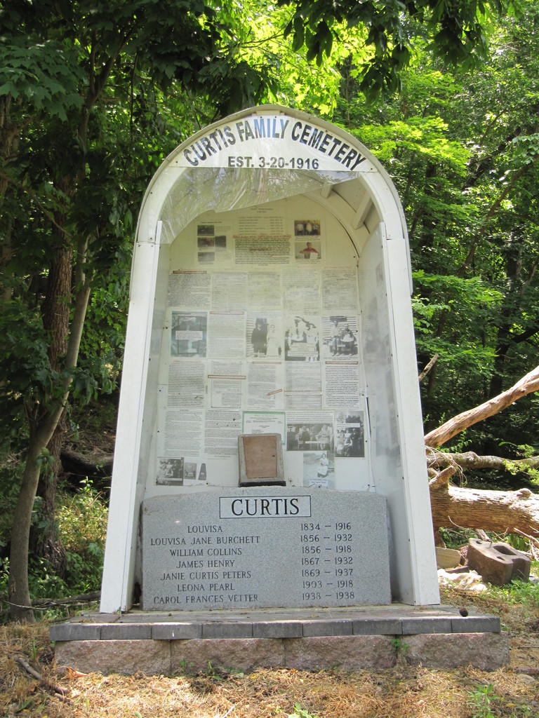
| Description | : | The Curtis Family Cemetery is located on Pleasant Dale road. Up Pleasant Dale Holler on the old Curtis Farm purchased in 1866 by Charles Curtis, It is basicly across the road from the Original Pleasant Dale Baptist Church (no longer used as a church) **** In October 2014 a "Main" stone was set at the foot of the hill where the Cemetery lies. since only a couple of brass name plates were recovered the "Main" stone list all known to have been buried there. |
frequently asked questions (FAQ):
-
Where is Curtis Cemetery?
Curtis Cemetery is located at Calhoun County ,Illinois ,USA.
-
Curtis Cemetery cemetery's updated grave count on graveviews.com?
0 memorials
-
Where are the coordinates of the Curtis Cemetery?
Latitude: 39.3517820
Longitude: -90.6552560
Nearby Cemetories:
1. Smith Cemetery
Calhoun County, USA
Coordinate: 39.3667074, -90.6753962
2. Retzer Cemetery
Calhoun County, USA
Coordinate: 39.3722000, -90.6727982
3. Spear Cemetery
Calhoun County, USA
Coordinate: 39.3700000, -90.6320000
4. Richter Cemetery
Kampsville, Calhoun County, USA
Coordinate: 39.3367940, -90.6886540
5. Silver Creek Cemetery
Kampsville, Calhoun County, USA
Coordinate: 39.3244019, -90.6271973
6. Hillcrest Cemetery
Calhoun County, USA
Coordinate: 39.3436012, -90.7155991
7. Humphrey Cemetery
Pike County, USA
Coordinate: 39.4063988, -90.6327972
8. Farrow Cemetery
Kampsville, Calhoun County, USA
Coordinate: 39.3007120, -90.6130680
9. Saint Anselms Cemetery
Kampsville, Calhoun County, USA
Coordinate: 39.2983540, -90.6150110
10. Summit Grove Cemetery
Kampsville, Calhoun County, USA
Coordinate: 39.2894670, -90.6667290
11. McConnell Cemetery
Calhoun County, USA
Coordinate: 39.3967970, -90.7210910
12. Schumann Cemetery
Kampsville, Calhoun County, USA
Coordinate: 39.2872626, -90.6098384
13. Miller Cemetery
Pearl, Pike County, USA
Coordinate: 39.4250406, -90.6303964
14. Kessinger Cemetery
Pearl, Pike County, USA
Coordinate: 39.4275900, -90.6529400
15. Hess Cemetery
Pearl, Pike County, USA
Coordinate: 39.4344851, -90.6626191
16. Fox Creek Cemetery
Mozier, Calhoun County, USA
Coordinate: 39.2924995, -90.7307968
17. Poor Cemetery
Mozier, Calhoun County, USA
Coordinate: 39.3213997, -90.7577972
18. Borium Cemetery
Walkerville, Greene County, USA
Coordinate: 39.3828182, -90.5506725
19. Bushnell Cemetery
Eldred, Greene County, USA
Coordinate: 39.3149160, -90.5510690
20. New Miller Cemetery
Pearl, Pike County, USA
Coordinate: 39.4379680, -90.6284900
21. Eldred-Bushnell Cemetery
Eldred, Greene County, USA
Coordinate: 39.3139293, -90.5515047
22. Bridgewater-Hunnicutt Cemetery
Walkerville, Greene County, USA
Coordinate: 39.3947626, -90.5545616
23. Gillingham and Rollins Cemetery
Walkerville, Greene County, USA
Coordinate: 39.3719847, -90.5292832
24. Eldred Memorial Gardens
Eldred, Greene County, USA
Coordinate: 39.2914292, -90.5431708