
| Memorials | : | 0 |
| Location | : | Shoals, Martin County, USA |
| Coordinate | : | 38.6279000, -86.8501000 |
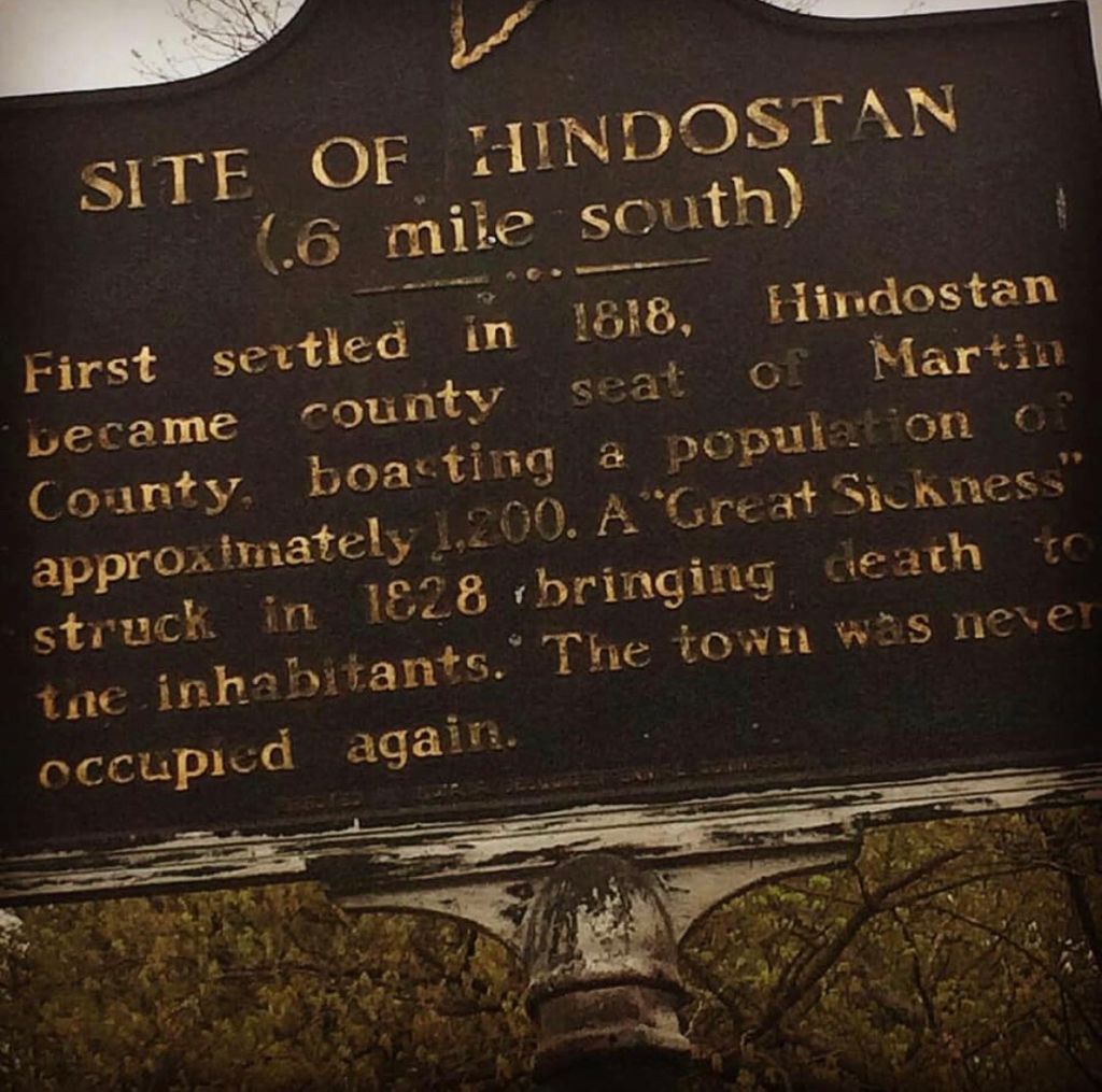
| Description | : | The cemetery is located in Center Township (NW quadrant of the NW quadrant of the NW quadrant of Section 10 Township 2N Range 4W) about 300 feet east of County Road 55 about 0.2 miles south of its intersection with Indiana State Highway 550. Indiana Cemetery Locations, Volume 3, published by the Indiana Genealogical Society (April 2007), gives the primary cemetery name as D.A.R. Cemetery. The cemetery is listed in the Cemetery and Burial Grounds Registry of the Indiana Department of Natural Resources (DNR) and in the State Historical Architectural and Archaeological Research Database (SHAARD) with Cemetery Record Number CR-51-7 (Hindostan /... Read More |
frequently asked questions (FAQ):
-
Where is DAR Cemetery?
DAR Cemetery is located at County Road 55 Shoals, Martin County ,Indiana , 47581USA.
-
DAR Cemetery cemetery's updated grave count on graveviews.com?
0 memorials
-
Where are the coordinates of the DAR Cemetery?
Latitude: 38.6279000
Longitude: -86.8501000
Nearby Cemetories:
1. Hindostan Cemetery #2
Hindostan Falls, Martin County, USA
Coordinate: 38.6280690, -86.8554260
2. Hindostan Cemetery
Shoals, Martin County, USA
Coordinate: 38.6323929, -86.8529358
3. Martin Cemetery
Shoals, Martin County, USA
Coordinate: 38.6399000, -86.8528000
4. Sholts Cemetery
Martin County, USA
Coordinate: 38.6389008, -86.8311005
5. Hitt Cemetery
Shoals, Martin County, USA
Coordinate: 38.6547000, -86.8405000
6. Holtsclaw Cemetery
Martin County, USA
Coordinate: 38.5988998, -86.8585968
7. Lloyd Cemetery
Shoals, Martin County, USA
Coordinate: 38.6592140, -86.8407950
8. Hall Cemetery
Shoals, Martin County, USA
Coordinate: 38.6563988, -86.8253021
9. Poplar Grove Wesleyan Church Cemetery
Martin County, USA
Coordinate: 38.6615105, -86.8626709
10. Abel Cemetery
Shoals, Martin County, USA
Coordinate: 38.6039590, -86.8164200
11. Davis Cemetery
Shoals, Martin County, USA
Coordinate: 38.6638000, -86.8537000
12. Brown Cemetery
Shoals, Martin County, USA
Coordinate: 38.6516480, -86.8149970
13. Saint Rose Cemetery
Mount Pleasant, Martin County, USA
Coordinate: 38.6507710, -86.8915500
14. Brooks Cemetery
Mount Pleasant, Martin County, USA
Coordinate: 38.6499557, -86.8948059
15. Houghton Cemetery
Mount Pleasant, Martin County, USA
Coordinate: 38.6509800, -86.8980310
16. Peek Cemetery
Shoals, Martin County, USA
Coordinate: 38.6699000, -86.8246000
17. Pleasant Valley Cemetery
Lacy, Martin County, USA
Coordinate: 38.6318630, -86.7888880
18. Saint Martin Catholic Cemetery
Whitfield, Martin County, USA
Coordinate: 38.6188889, -86.9135132
19. Salmon Cemetery
Martin County, USA
Coordinate: 38.6773390, -86.8032050
20. Fraim Cemetery
Loogootee, Martin County, USA
Coordinate: 38.6651270, -86.9140110
21. Double Oak Cemetery
Lost River Township, Martin County, USA
Coordinate: 38.5682000, -86.8239000
22. Green Cemetery
Martin County, USA
Coordinate: 38.5661011, -86.8317032
23. Truelove Cemetery
Loogootee, Martin County, USA
Coordinate: 38.5772018, -86.9002991
24. Waggoner's Chapel Cemetery
Shoals, Martin County, USA
Coordinate: 38.5806081, -86.7944414