| Memorials | : | 0 |
| Location | : | Jerico Springs, Cedar County, USA |
| Coordinate | : | 37.6357130, -93.9700130 |
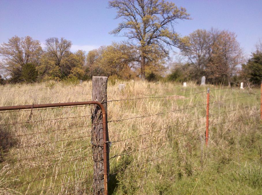
| Description | : | This cemetery is out in the middle of a pasture. Has not been cared for. As you go on B Highway east of Jerico go north on 601 rd. the road ends and connects to 1826 rd. The Cemetery is located North/West of that intersection. There is a white house (unoccupied) the metal building on the west side of the house is the new house. You will need permission to go to the cemetery. |
frequently asked questions (FAQ):
-
Where is Deardorff Cemetery?
Deardorff Cemetery is located at Jerico Springs, Cedar County ,Missouri ,USA.
-
Deardorff Cemetery cemetery's updated grave count on graveviews.com?
0 memorials
-
Where are the coordinates of the Deardorff Cemetery?
Latitude: 37.6357130
Longitude: -93.9700130
Nearby Cemetories:
1. Anna-Edna Cemetery
Jerico Springs, Cedar County, USA
Coordinate: 37.6119003, -94.0010986
2. Hall Cemetery
Jerico Springs, Cedar County, USA
Coordinate: 37.6744003, -93.9933014
3. Brasher Cemetery
Jerico Springs, Cedar County, USA
Coordinate: 37.6389008, -94.0261002
4. Wagoner Cemetery
Stockton, Cedar County, USA
Coordinate: 37.6664009, -93.9250031
5. Zion Cemetery
Jerico Springs, Cedar County, USA
Coordinate: 37.5946999, -94.0111008
6. Brandenburg Farm Cemetery
Benton Township, Cedar County, USA
Coordinate: 37.6457214, -94.0395148
7. Noffsinger Cemetery
Cedar County, USA
Coordinate: 37.6227989, -93.8957977
8. Oldham Cemetery
Cedar County, USA
Coordinate: 37.6796989, -94.0274963
9. Omer Cemetery
Stockton, Cedar County, USA
Coordinate: 37.5966988, -93.9060974
10. Greenfield Cemetery
Jerico Springs, Cedar County, USA
Coordinate: 37.5811005, -94.0205994
11. Cedarville Cemetery
Cedarville, Dade County, USA
Coordinate: 37.5665090, -93.9802090
12. Wiley Cemetery
Stockton, Cedar County, USA
Coordinate: 37.6336740, -93.8776590
13. Hunter - O'Connor Cemetery
Jerico Springs, Cedar County, USA
Coordinate: 37.6256200, -93.8621200
14. Hamby Cemetery
Stockton, Cedar County, USA
Coordinate: 37.7317009, -93.9591980
15. Sehorn Cemetery
Olympia, Cedar County, USA
Coordinate: 37.7377980, -93.9610650
16. Sandridge Cemetery
El Dorado Springs, Cedar County, USA
Coordinate: 37.7406006, -93.9982986
17. Gum Springs Cemetery
Stockton, Cedar County, USA
Coordinate: 37.6515198, -93.8281326
18. Amos Cemetery
Dade County, USA
Coordinate: 37.5222015, -93.9878006
19. Younger Cemetery
Stockton, Cedar County, USA
Coordinate: 37.6876984, -93.8330078
20. Achord Cemetery
Arcola, Dade County, USA
Coordinate: 37.5539017, -93.8569031
21. Walnut Grove Cemetery
Cedar County, USA
Coordinate: 37.7305984, -94.0689011
22. Round Prairie Cemetery
Milford, Barton County, USA
Coordinate: 37.5752983, -94.1082993
23. Saint James Cemetery
Milford, Barton County, USA
Coordinate: 37.6282020, -94.1323610
24. Hickory Grove Cemetery
Arcola, Dade County, USA
Coordinate: 37.5285988, -93.8780975

