
| Memorials | : | 2 |
| Location | : | Delaware, Daviess County, USA |
| Coordinate | : | 37.6859130, -87.4041040 |
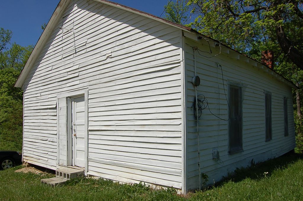
| Description | : | The picture of the church building on Delaware Ferry lane is the Methodist. The picture shown is the one of the Delaware Christian Church, organized in 1877 and the building was erected in 1884. The measurements are 50 x 40 feet. The Methodist Church was located off of what is now Hulsey Lane across the field from the Methodist Cemetery. The Methodist Church was built in 1875, measured 52 by 34 feet and stood fourteen feet high. It was torn down sometime after Mr. A.M. Allen died in 1910 after falling into disrepair. Source of information: History of Daviess County... Read More |
frequently asked questions (FAQ):
-
Where is Delaware Church Cemetery?
Delaware Church Cemetery is located at Delaware, Daviess County ,Kentucky ,USA.
-
Delaware Church Cemetery cemetery's updated grave count on graveviews.com?
2 memorials
-
Where are the coordinates of the Delaware Church Cemetery?
Latitude: 37.6859130
Longitude: -87.4041040
Nearby Cemetories:
1. Jewell Cemetery
Saint Joseph, Daviess County, USA
Coordinate: 37.6804199, -87.3699799
2. Pleasant Hill Cumberland Presb. Church Cemetery
Elba, McLean County, USA
Coordinate: 37.6660690, -87.3741989
3. Watkins Cemetery #2
Niagara, Henderson County, USA
Coordinate: 37.7120040, -87.4439620
4. Cash Creek Baptist Church Cemetery
Niagara, Henderson County, USA
Coordinate: 37.7248700, -87.4202900
5. Nunn Cemetery
Henderson County, USA
Coordinate: 37.6893997, -87.4561005
6. Ward Cemetery
Comer, McLean County, USA
Coordinate: 37.6488960, -87.4371560
7. Travis Cemetery
Saint Joseph, Daviess County, USA
Coordinate: 37.6777992, -87.3469009
8. Corey Cemetery
McLean County, USA
Coordinate: 37.6383018, -87.4216995
9. Collier Biggs Cemetery
Niagara, Henderson County, USA
Coordinate: 37.7150000, -87.4565860
10. Jones Cemetery
Niagara, Henderson County, USA
Coordinate: 37.7308650, -87.4371920
11. Watkins Cemetery
Niagara, Henderson County, USA
Coordinate: 37.7215200, -87.4553900
12. Boston Cemetery
Comer, McLean County, USA
Coordinate: 37.6399994, -87.4428024
13. Mackey Cemetery
McLean County, USA
Coordinate: 37.6306000, -87.3944016
14. Hunter Cemetery
Comer, McLean County, USA
Coordinate: 37.6326860, -87.4337110
15. Bethel Baptist Cemetery
Beech Grove, McLean County, USA
Coordinate: 37.6274796, -87.3872986
16. Mount Zion Cemetery
Beech Grove, McLean County, USA
Coordinate: 37.6250000, -87.3927994
17. Saint Alphonsus Cemetery
Saint Joseph, Daviess County, USA
Coordinate: 37.6948800, -87.3247700
18. McCain Cemetery
Curdsville, Daviess County, USA
Coordinate: 37.7322006, -87.3480988
19. Craig-Reid Cemetery
Hebbardsville, Henderson County, USA
Coordinate: 37.7506500, -87.3985800
20. Mount Saint Joseph Cemetery
Maple Mount, Daviess County, USA
Coordinate: 37.6931000, -87.3216570
21. Saint Benedict Catholic Cemetery
Beech Grove, McLean County, USA
Coordinate: 37.6195717, -87.3959427
22. Griffin Cemetery
Niagara, Henderson County, USA
Coordinate: 37.7380650, -87.4581030
23. Pleasant Valley Cemetery
Henderson County, USA
Coordinate: 37.6933440, -87.4892580
24. Lynn Family Graveyard
Beech Grove, McLean County, USA
Coordinate: 37.6140000, -87.3960000