
| Memorials | : | 0 |
| Location | : | Diamond, Grundy County, USA |
| Coordinate | : | 41.2886860, -88.2504790 |
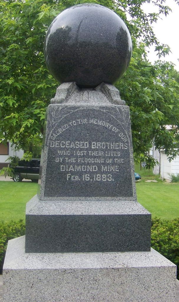
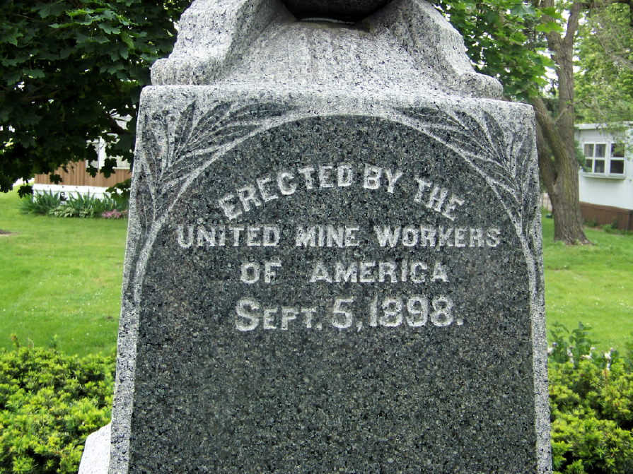
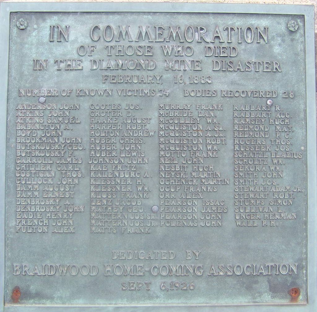
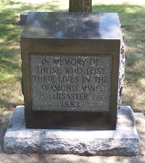
| Description | : | The Diamond Mine Disaster The Diamond Mine of the Wilmington Coal Mining and Manufacturing Company, located near Braidwood on the Grundy-Will County line, was the site of a major mine disaster in Illinois. The mine was on a marshy tract of land that had no natural drainage. At midday of February 16, 1883, the east side of the mine collapsed from the weight of melting snow, ice, and heavy rains. An alarm was sounded, and miners who were near the escapement shaft hurried to the surface. The main passage to the shaft flooded rapidly, and the... Read More |
frequently asked questions (FAQ):
-
Where is Diamond Illinois Coal Mine Memorial?
Diamond Illinois Coal Mine Memorial is located at 2316 E Division Street / Main Street Diamond, Grundy County ,Illinois , 60416USA.
-
Diamond Illinois Coal Mine Memorial cemetery's updated grave count on graveviews.com?
0 memorials
-
Where are the coordinates of the Diamond Illinois Coal Mine Memorial?
Latitude: 41.2886860
Longitude: -88.2504790


Nearby Cemetories:
1. Italian Cemetery
Coal City, Grundy County, USA
Coordinate: 41.2759700, -88.2800000
2. Short Cemetery
Carbon Hill, Grundy County, USA
Coordinate: 41.3311005, -88.2881012
3. Mount Olivet Cemetery
Braidwood, Will County, USA
Coordinate: 41.2433014, -88.2058029
4. Brown Cemetery
Custer Park, Will County, USA
Coordinate: 41.2607750, -88.1849380
5. Bohemian National Cemetery
Braidwood, Will County, USA
Coordinate: 41.2531013, -88.1911011
6. Cotton Cemetery
Braceville, Grundy County, USA
Coordinate: 41.2300040, -88.2625240
7. Oakwood Cemetery
Braidwood, Will County, USA
Coordinate: 41.2510986, -88.1866989
8. Braceville-Gardner Cemetery
Braceville, Grundy County, USA
Coordinate: 41.2296000, -88.2784500
9. Mount Olivet Cemetery
Wilmington, Will County, USA
Coordinate: 41.2988400, -88.1462600
10. Oakwood Cemetery
Wilmington, Will County, USA
Coordinate: 41.3012100, -88.1458900
11. Custer Township Cemetery
Custer Park, Will County, USA
Coordinate: 41.2417030, -88.1303960
12. Forbes - Goodings Farm Cemetery
Goodings Grove, Will County, USA
Coordinate: 41.2800255, -88.1150589
13. White-Holderman Cemetery
Claypool, Grundy County, USA
Coordinate: 41.3582993, -88.3685989
14. North Essex Cemetery
Essex, Kankakee County, USA
Coordinate: 41.1866989, -88.1832962
15. Saint Anthonys Cemetery
Aux Sable, Grundy County, USA
Coordinate: 41.4035988, -88.2767029
16. Sample Cemetery
Morris, Grundy County, USA
Coordinate: 41.3382988, -88.3917007
17. South Essex Cemetery
Essex, Kankakee County, USA
Coordinate: 41.1760000, -88.1686000
18. Reeds Grove Cemetery
Elwood, Will County, USA
Coordinate: 41.3848900, -88.1332200
19. Old Mazon Cemetery
Mazon, Grundy County, USA
Coordinate: 41.2196400, -88.3981000
20. Evergreen Cemetery
Morris, Grundy County, USA
Coordinate: 41.3692017, -88.3921967
21. Starrs Grove Cemetery
Wilmington, Will County, USA
Coordinate: 41.3602982, -88.0999985
22. McCune Cemetery
Channahon, Will County, USA
Coordinate: 41.4071500, -88.1584800
23. Newton Cemetery
Wilmington, Will County, USA
Coordinate: 41.4103400, -88.1647100
24. Wheeler Cemetery
Mazon, Grundy County, USA
Coordinate: 41.2043991, -88.3955994