| Memorials | : | 1 |
| Location | : | Overisel, Allegan County, USA |
| Coordinate | : | 42.6811714, -85.9235535 |
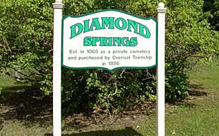
| Description | : | On 136th Street, about 50 yards west of 38th Street on the north side of the road. Cemetery is very rundown and many of the stones are destroyed. 1868: Diamond Springs Cemetery was established as a private cemetery. 1886: Purchased by Overisal Township. |
frequently asked questions (FAQ):
-
Where is Diamond Springs Cemetery?
Diamond Springs Cemetery is located at Overisel, Allegan County ,Michigan ,USA.
-
Diamond Springs Cemetery cemetery's updated grave count on graveviews.com?
1 memorials
-
Where are the coordinates of the Diamond Springs Cemetery?
Latitude: 42.6811714
Longitude: -85.9235535
Nearby Cemetories:
1. Dowd Cemetery
Hamilton, Allegan County, USA
Coordinate: 42.6736030, -85.9180503
2. Bentheim Cemetery
Bentheim, Allegan County, USA
Coordinate: 42.7136130, -85.9195660
3. Riverside Cemetery
Hamilton, Allegan County, USA
Coordinate: 42.6813000, -86.0049900
4. Oakland Cemetery
Overisel Township, Allegan County, USA
Coordinate: 42.7460100, -85.9300850
5. Brookside Cemetery
Dunningville, Allegan County, USA
Coordinate: 42.6133003, -85.9567032
6. Overisel Cemetery
Overisel, Allegan County, USA
Coordinate: 42.7318510, -86.0025290
7. Overisel Settlers Cemetery
Overisel, Allegan County, USA
Coordinate: 42.7287422, -86.0142589
8. VanDam Family Cemetery
Drenthe, Ottawa County, USA
Coordinate: 42.7597430, -85.9566880
9. Van Dam Family Cemetery
Overisel, Allegan County, USA
Coordinate: 42.7605475, -85.9597169
10. Salem Township Cemetery
Burnips, Allegan County, USA
Coordinate: 42.7387910, -85.8390830
11. Poplar Hill Cemetery
Monterey Township, Allegan County, USA
Coordinate: 42.6161003, -85.8416977
12. Woodcock Cemetery
Manlius Township, Allegan County, USA
Coordinate: 42.6456700, -86.0355800
13. East Drenthe Cemetery
Drenthe, Ottawa County, USA
Coordinate: 42.7747002, -85.9313965
14. Old Drenthe Cemetery
Zeeland Township, Ottawa County, USA
Coordinate: 42.7792830, -85.9419360
15. Allegan County Poor Farm Cemetery
Allegan, Allegan County, USA
Coordinate: 42.5809890, -85.8691040
16. Jewett Cemetery
South Monterey, Allegan County, USA
Coordinate: 42.5792007, -85.8735962
17. Millgrove Cemetery
Allegan, Allegan County, USA
Coordinate: 42.5722220, -85.9177770
18. West Drenthe Cemetery
Drenthe, Ottawa County, USA
Coordinate: 42.7834960, -85.9749050
19. Saint Pauls Evangelical Lutheran Cemetery
Hopkins, Allegan County, USA
Coordinate: 42.6317960, -85.7805200
20. Valley Township Cemetery
Fennville, Allegan County, USA
Coordinate: 42.5863808, -86.0158280
21. Tanner Cemetery
Dorr, Allegan County, USA
Coordinate: 42.6955986, -85.7602997
22. East Holland Cemetery
Fillmore Township, Allegan County, USA
Coordinate: 42.7661018, -86.0436020
23. Saint Marys Catholic Church Cemetery of New Salem
Salem Township, Allegan County, USA
Coordinate: 42.7543900, -85.7883700
24. Lakeview Cemetery
Hopkins, Allegan County, USA
Coordinate: 42.6460991, -85.7608032

