
| Memorials | : | 19 |
| Location | : | La Grange, Lewis County, USA |
| Coordinate | : | 40.0109700, -91.5979100 |
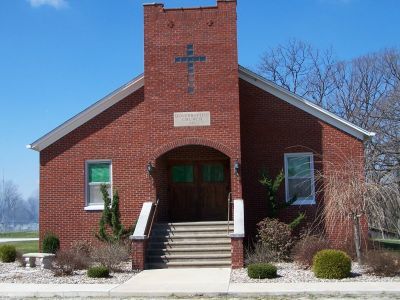
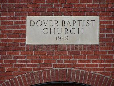
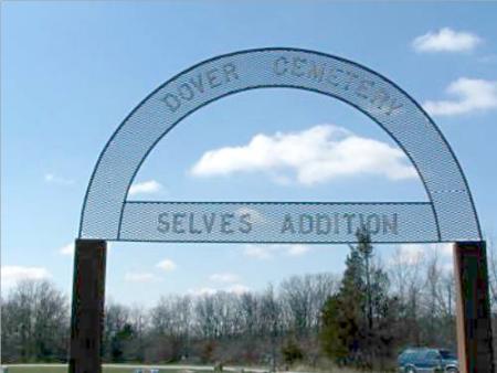
| Description | : | From US 61 in Lewis County Missouri about 1 ½ miles north of the US 24 & 61 junction at Taylor, go west on route V for slightly more than 2 miles and take a right turn (north) onto route Z. The Dover Baptist Church will be on the left side in 4 ½ miles. The original graveyard is mostly hidden from view from the road by trees but is located behind the brick church and is easily accessible and well kept. The newer “Selves Addition” is beside route Z on the left, about a quarter of a mile further... Read More |
frequently asked questions (FAQ):
-
Where is Dover Cemetery?
Dover Cemetery is located at La Grange, Lewis County ,Missouri ,USA.
-
Dover Cemetery cemetery's updated grave count on graveviews.com?
17 memorials
-
Where are the coordinates of the Dover Cemetery?
Latitude: 40.0109700
Longitude: -91.5979100
Nearby Cemetories:
1. Liberty Cemetery
La Grange, Lewis County, USA
Coordinate: 39.9975000, -91.5683330
2. Maywood Cemetery
Maywood, Lewis County, USA
Coordinate: 39.9597015, -91.5883026
3. Durham Cemetery
Durham, Lewis County, USA
Coordinate: 39.9802300, -91.6670200
4. Gilead Cemetery
Ewing, Lewis County, USA
Coordinate: 40.0194600, -91.6778400
5. Cool Spring Cemetery
Lewis County, USA
Coordinate: 40.0256004, -91.6810989
6. Briscoe Cemetery
Ewing, Lewis County, USA
Coordinate: 40.0074997, -91.6889038
7. Salter Cemetery
La Grange, Lewis County, USA
Coordinate: 40.0477982, -91.5186005
8. Hebron Cemetery
Marion County, USA
Coordinate: 39.9399986, -91.6219025
9. LaGrange Memorial Cemetery
La Grange, Lewis County, USA
Coordinate: 40.0484780, -91.5128090
10. Cason Cemetery
Lewis County, USA
Coordinate: 40.0346985, -91.6956024
11. Riverview Cemetery
La Grange, Lewis County, USA
Coordinate: 40.0388985, -91.5017014
12. Humphrey Cemetery
Emerson, Marion County, USA
Coordinate: 39.9466610, -91.6613820
13. Ten Mile Cemetery
Canton, Lewis County, USA
Coordinate: 40.0849300, -91.6484900
14. Marks Cemetery
La Grange, Lewis County, USA
Coordinate: 40.0516080, -91.5013610
15. Apostolic Cemetery
Taylor, Marion County, USA
Coordinate: 39.9446100, -91.5295400
16. Cave Cemetery
Hester, Marion County, USA
Coordinate: 39.9220700, -91.5803400
17. Sudduth Cemetery
Marion County, USA
Coordinate: 39.9211000, -91.5918400
18. Sunrise Cemetery
Marion County, USA
Coordinate: 39.9207993, -91.6232986
19. Garnett Cemetery
Lewis County, USA
Coordinate: 40.0886002, -91.6631012
20. Queen of Peace Cemetery
Ewing, Lewis County, USA
Coordinate: 40.0089600, -91.7194300
21. Shackleford Cemetery
Lewis County, USA
Coordinate: 39.9867200, -91.7158000
22. Nall Cemetery
Monticello, Lewis County, USA
Coordinate: 40.0717010, -91.6908035
23. Ewing Memorial Cemetery
Ewing, Lewis County, USA
Coordinate: 40.0094210, -91.7202510
24. German Lutheran Cemetery
Ewing, Lewis County, USA
Coordinate: 40.0100000, -91.7205556