
| Memorials | : | 0 |
| Location | : | Dearing, McDuffie County, USA |
| Coordinate | : | 33.4605500, -82.3799800 |
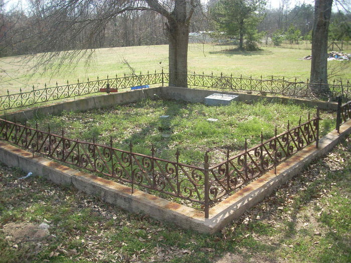
| Description | : | Drane Family Cemetery #2 is located on the west side of County Line Road, 0.1 miles south of Watson Bailey Road. The cemetery is in a field to the west of County Line Road. It is surrounded by an iron fence. "Drane" is inscribed on the rock threshold at the gate. |
frequently asked questions (FAQ):
-
Where is Drane Family Cemetery #2?
Drane Family Cemetery #2 is located at Dearing, McDuffie County ,Georgia ,USA.
-
Drane Family Cemetery #2 cemetery's updated grave count on graveviews.com?
0 memorials
-
Where are the coordinates of the Drane Family Cemetery #2?
Latitude: 33.4605500
Longitude: -82.3799800
Nearby Cemetories:
1. Cobb Grove Baptist Church Cemetery
Columbia County, USA
Coordinate: 33.4680630, -82.3836850
2. Samuel Wesley Bailey Homeplace Cemetery
Columbia County, USA
Coordinate: 33.4780220, -82.3822370
3. Lamkin Cemetery
Columbia County, USA
Coordinate: 33.4618988, -82.3550034
4. Drane Family Cemetery
Dearing, McDuffie County, USA
Coordinate: 33.4383800, -82.3748700
5. Cedar Grove Baptist Church Cemetery
Harlem, Columbia County, USA
Coordinate: 33.4877586, -82.3490524
6. Piney Grove Cemetery
McDuffie County, USA
Coordinate: 33.4193993, -82.3685989
7. Dearing United Methodist Church Cemetery
Dearing, McDuffie County, USA
Coordinate: 33.4167000, -82.3828920
8. Dearing City Cemetery
Dearing, McDuffie County, USA
Coordinate: 33.4163710, -82.3828390
9. Harris Family Cemetery
Dearing, McDuffie County, USA
Coordinate: 33.4159100, -82.3833920
10. Norris Chapel Holiness Church Cemetery
Dearing, McDuffie County, USA
Coordinate: 33.4181990, -82.3577360
11. Marshall Baptist Church Cemetery
McDuffie County, USA
Coordinate: 33.4947014, -82.4194031
12. Cherry Hill Baptist Church Cemetery
Harlem, Columbia County, USA
Coordinate: 33.4233310, -82.3363530
13. Jones Chapel C.M.E. Church Cemetery
Appling, Columbia County, USA
Coordinate: 33.5114220, -82.3998150
14. Jehovah Witness Church Cemetery
Boneville, McDuffie County, USA
Coordinate: 33.4190640, -82.4265230
15. Mount Tabor Baptist Church Cemetery
Harlem, Columbia County, USA
Coordinate: 33.4187400, -82.3334600
16. Mount Gilead Baptist Church Cemetery
Dearing, McDuffie County, USA
Coordinate: 33.4201340, -82.4295990
17. Fountain Grove Baptist Church Cemetery
Harlem, Columbia County, USA
Coordinate: 33.4628105, -82.3104324
18. Boneville United Methodist Church Cemetery
McDuffie County, USA
Coordinate: 33.4342420, -82.4430870
19. Woodlawn CME Church Cemetery
Columbia County, USA
Coordinate: 33.4768038, -82.3115125
20. White Oak United Methodist Church Cemetery
Appling, Columbia County, USA
Coordinate: 33.5190245, -82.3951260
21. DeArmond - Fuller - Crowder Family Cemetery
Columbia County, USA
Coordinate: 33.4787800, -82.3113500
22. United House of Prayer for All People Cemetery
Dearing, McDuffie County, USA
Coordinate: 33.4063810, -82.4186240
23. Saint Luke's Church Cemetery
Thomson, McDuffie County, USA
Coordinate: 33.4775320, -82.4529500
24. Phillips Homeplace
McDuffie County, USA
Coordinate: 33.3950550, -82.3948220