
| Memorials | : | 0 |
| Location | : | Dun, Fosnes kommune, Norway |
| Coordinate | : | 64.6571620, 11.2606180 |
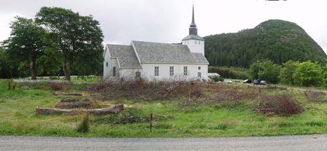
| Description | : | Dun Church and Cemetery is located on Jøa in Outer Namdalingen. The church was built in 1949 and is a wooden church. The church is located in a beautiful landscape rooms at the community center Dun, bounded by mountains and with views towards foals. |
frequently asked questions (FAQ):
-
Where is Dun Kirkegaard?
Dun Kirkegaard is located at Dun, Fosnes kommune ,Nord-Trøndelag fylke ,Norway.
-
Dun Kirkegaard cemetery's updated grave count on graveviews.com?
0 memorials
-
Where are the coordinates of the Dun Kirkegaard?
Latitude: 64.6571620
Longitude: 11.2606180
Nearby Cemetories:
1. Fosnes Church Cemetery
Mo, Fosnes kommune, Norway
Coordinate: 64.6838470, 11.3004880
2. Salen Kapell Graveyard
Salsnes, Fosnes kommune, Norway
Coordinate: 64.6963230, 11.4543950
3. Otterøy Kirkegaard
Otteroy, Namsos kommune, Norway
Coordinate: 64.5113560, 11.2979880
4. Lundring Church Cemetery
Kolvereid, Nærøy kommune, Norway
Coordinate: 64.8166000, 11.2554100
5. Vemundvik Kirkegaard
Vemundvik, Namsos kommune, Norway
Coordinate: 64.5165451, 11.5418644
6. Løvøya Cemetery
Lauvsnes, Flatanger kommune, Norway
Coordinate: 64.5127360, 10.8825590
7. Namsos Kirkegaard
Namsos, Namsos kommune, Norway
Coordinate: 64.4683310, 11.5167450
8. Høknes Cemetery
Namsos, Namsos kommune, Norway
Coordinate: 64.4749740, 11.5609980
9. Høknes Gravlund
Hoyknes, Namsos kommune, Norway
Coordinate: 64.4725600, 11.5605000
10. Kolvereid Kirkegaard
Kolvereid, Nærøy kommune, Norway
Coordinate: 64.8665690, 11.5966350
11. Klinga Kirke
Klinga, Namsos kommune, Norway
Coordinate: 64.4066010, 11.4816270
12. Skage Kirkegaard
Ranemsletta, Overhalla kommune, Norway
Coordinate: 64.4640210, 11.7562300
13. Vik Kirkegaard
Vik, Flatanger kommune, Norway
Coordinate: 64.4557070, 10.7613890
14. Ranem Kirkegaard
Ranemsletta, Overhalla kommune, Norway
Coordinate: 64.4932120, 11.9492290
15. Gravvik
Foldereid, Nærøy kommune, Norway
Coordinate: 64.9899070, 11.7685820
16. Gravvik Church Cemetery
Gravvika, Nærøy kommune, Norway
Coordinate: 64.9901000, 11.7688000
17. Namdalseid Kirkegaard
Namdalseid, Namdalseid kommune, Norway
Coordinate: 64.2186370, 11.2096510
18. Leka Church Cemetery
Leknes, Leka kommune, Norway
Coordinate: 65.0888000, 11.7095000
19. Grong
Grong, Grong kommune, Norway
Coordinate: 64.4667610, 12.2957910
20. Osen Kirkegaard
Osen kommune, Norway
Coordinate: 64.2991100, 10.5053460
21. Gløshaug kirkegård
Gartland, Grong kommune, Norway
Coordinate: 64.5347936, 12.4016490
22. Harran
Grong, Grong kommune, Norway
Coordinate: 64.5595160, 12.4864010
23. Beitstad Kirke
Steinkjer kommune, Norway
Coordinate: 64.0863869, 11.3282113
24. Hofstad Cemetery
Roan, Roan kommune, Norway
Coordinate: 64.1920890, 10.4121470