
| Memorials | : | 0 |
| Location | : | Globe, Carter County, USA |
| Coordinate | : | 38.2888680, -83.2200190 |
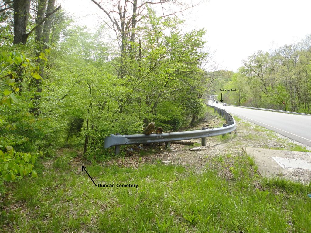
| Description | : | DUNCAN CEMETERY-1 Location from Courthouse in Grayson: US 60 West to Route 2078 (Garvin Ridge Road) entrance; pull over on left of road and park at end of guardrail directly across highway from Garvin Ridge Road. Walk along guard rail a short distance to cemetery in woods adjacent to highway. Located just down the road from the Globe Funeral Home. There are 8 listed as being buried in the cemetery. Per Rattlesnake Ridge Genealogy Group cemetery survey, 2005 |
frequently asked questions (FAQ):
-
Where is Duncan Cemetery #1?
Duncan Cemetery #1 is located at US 60 W & Route 2078 (Garvin Ridge Road) Globe, Carter County ,Kentucky ,USA.
-
Duncan Cemetery #1 cemetery's updated grave count on graveviews.com?
0 memorials
-
Where are the coordinates of the Duncan Cemetery #1?
Latitude: 38.2888680
Longitude: -83.2200190
Nearby Cemetories:
1. Vanhoose Cemetery
Globe, Carter County, USA
Coordinate: 38.2907210, -83.2017780
2. Webb Cemetery #1
Globe, Carter County, USA
Coordinate: 38.2958990, -83.2373320
3. Downing - Kiser Cemetery
Globe, Carter County, USA
Coordinate: 38.2838760, -83.2462230
4. Archer-Osborne Cemetery
Carter County, USA
Coordinate: 38.2649560, -83.2308160
5. Dean Cemetery #1
Globe, Carter County, USA
Coordinate: 38.2917970, -83.2535130
6. Dean Cemetery #3
Enterprise, Carter County, USA
Coordinate: 38.2507240, -83.2513780
7. Clark Cemetery #1
Carter County, USA
Coordinate: 38.3332050, -83.2022250
8. Armstrong Cemetery
Carter County, USA
Coordinate: 38.2939210, -83.1574960
9. Dean Cemetery #4
Carter County, USA
Coordinate: 38.3392260, -83.1973510
10. Bego Cemetery
Carter County, USA
Coordinate: 38.2322000, -83.2343960
11. Parker Cemetery
Carter, Carter County, USA
Coordinate: 38.2817940, -83.1462640
12. Gilliam Family Cemetery
Carter County, USA
Coordinate: 38.3484700, -83.2175600
13. Clark Cemetery #2
Carter County, USA
Coordinate: 38.2578011, -83.2874985
14. Stamper Cemetery
Emerson, Lewis County, USA
Coordinate: 38.3425400, -83.2687700
15. McFerren Cemetery
Garvin Ridge, Carter County, USA
Coordinate: 38.3077660, -83.1378920
16. Manning Chapel Cemetery
Carter, Carter County, USA
Coordinate: 38.2361380, -83.2746280
17. Cline Cemetery
Ault, Elliott County, USA
Coordinate: 38.2268992, -83.1813985
18. Eagle Hall Cemetery
Enterprise, Carter County, USA
Coordinate: 38.2552910, -83.2970250
19. Creech-Cline Cemetery
Ault, Elliott County, USA
Coordinate: 38.2218310, -83.1966620
20. Owens Cemetery
Emerson, Lewis County, USA
Coordinate: 38.3479510, -83.2721630
21. Brinegar Cemetery
Carter County, USA
Coordinate: 38.3107600, -83.1258100
22. Brack Mabry Cemetery
Elliott County, USA
Coordinate: 38.2284410, -83.1514990
23. Enix Cemetery
Fitch, Carter County, USA
Coordinate: 38.3060426, -83.3284458
24. Oscar L Erwin Cemetery
Enterprise, Carter County, USA
Coordinate: 38.3609070, -83.1557380