
| Memorials | : | 34 |
| Location | : | Mount Horeb, Dane County, USA |
| Coordinate | : | 42.9741707, -89.7494431 |
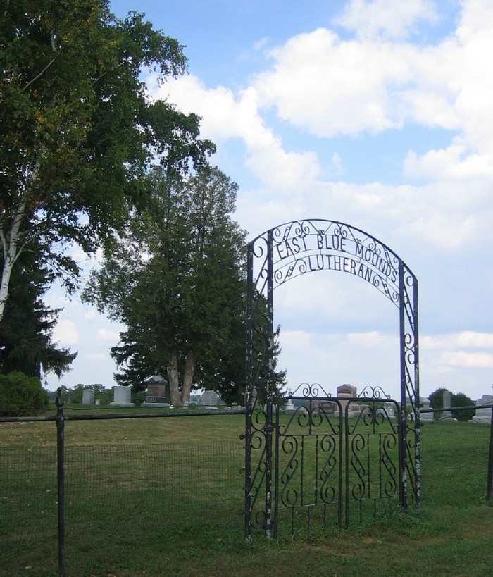
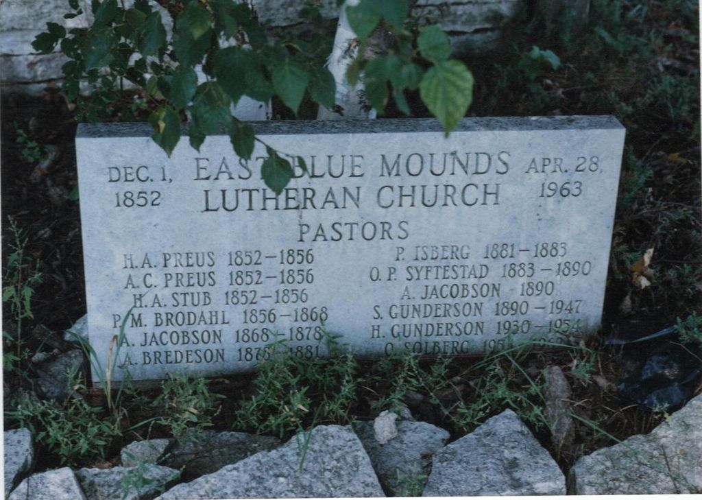
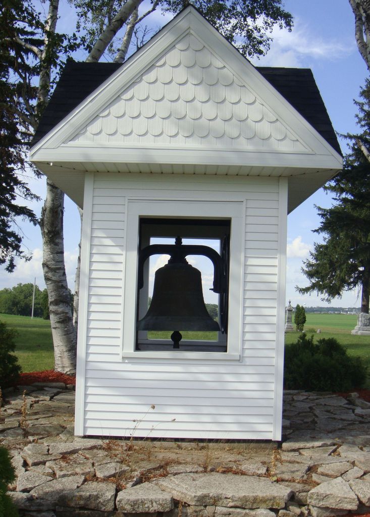
| Description | : | This cemetery is at the site of an old Lutheran church, which was here from Dec.1, 1852 to Apr.4, 1963. Its original steeple bell is enclosed in the little building. The original corner stone is in the stone platform , as is the list of its serving pastors |
frequently asked questions (FAQ):
-
Where is East Blue Mounds Lutheran Cemetery?
East Blue Mounds Lutheran Cemetery is located at Mount Horeb, Dane County ,Wisconsin ,USA.
-
East Blue Mounds Lutheran Cemetery cemetery's updated grave count on graveviews.com?
30 memorials
-
Where are the coordinates of the East Blue Mounds Lutheran Cemetery?
Latitude: 42.9741707
Longitude: -89.7494431
Nearby Cemetories:
1. German Valley Cemetery
Blue Mounds, Dane County, USA
Coordinate: 42.9808006, -89.7889023
2. Mount Horeb Union Cemetery
Mount Horeb, Dane County, USA
Coordinate: 43.0107994, -89.7294006
3. Holy Redeemers Cemetery
Daleyville, Dane County, USA
Coordinate: 42.9263916, -89.7663879
4. North Side Cemetery
Mount Horeb, Dane County, USA
Coordinate: 43.0242004, -89.7257996
5. Saint Ignatius Calvary Cemetery
Mount Horeb, Dane County, USA
Coordinate: 43.0212173, -89.7150210
6. Springdale Lutheran Church Cemetery
Mount Horeb, Dane County, USA
Coordinate: 43.0062294, -89.6904984
7. First Norwegian Lutheran Cemetery
Mount Horeb, Dane County, USA
Coordinate: 43.0172460, -89.6984120
8. Hauge Log Church Cemetery
Daleyville, Dane County, USA
Coordinate: 42.9300000, -89.8196716
9. West Blue Mounds Lutheran Cemetery
Blue Mounds, Dane County, USA
Coordinate: 43.0138800, -89.8247200
10. Mount Vernon Cemetery
Mount Vernon, Dane County, USA
Coordinate: 42.9552994, -89.6560974
11. Hauge Lutheran Cemetery
Daleyville, Dane County, USA
Coordinate: 42.9041061, -89.7889023
12. Perry Lutheran Cemetery
Daleyville, Dane County, USA
Coordinate: 42.9136009, -89.8176498
13. Oak Hill Cemetery
Springdale, Dane County, USA
Coordinate: 42.9644012, -89.6274950
14. Saint James Catholic Cemetery
Vermont, Dane County, USA
Coordinate: 43.0561100, -89.8097200
15. Natural Path Sanctuary Burial Ground
Verona, Dane County, USA
Coordinate: 42.9832200, -89.6099600
16. Saint Mary of Pine Bluff Catholic Church Cemetery
Pine Bluff, Dane County, USA
Coordinate: 43.0555500, -89.6586100
17. East Primrose Cemetery
Primrose, Dane County, USA
Coordinate: 42.8833008, -89.6763992
18. White Church Cemetery
Barneveld, Iowa County, USA
Coordinate: 43.0191994, -89.8807983
19. West Primrose Cemetery
Primrose, Dane County, USA
Coordinate: 42.8800011, -89.6813965
20. Mount Pleasant Cemetery
Primrose, Dane County, USA
Coordinate: 42.8944016, -89.6466980
21. Middlebury Cemetery
Barneveld, Iowa County, USA
Coordinate: 42.9385986, -89.9009628
22. Vermont Lutheran Church Cemetery
Black Earth, Dane County, USA
Coordinate: 43.0916710, -89.7477798
23. Vermont Pioneer Cemetery
Black Earth, Dane County, USA
Coordinate: 43.0941600, -89.7530500
24. Bethel Cemetery
Barneveld, Iowa County, USA
Coordinate: 43.0386009, -89.8906021