
| Memorials | : | 0 |
| Location | : | Bamberg, Stadtkreis Bamberg, Germany |
| Coordinate | : | 50.0980052, 10.7917598 |
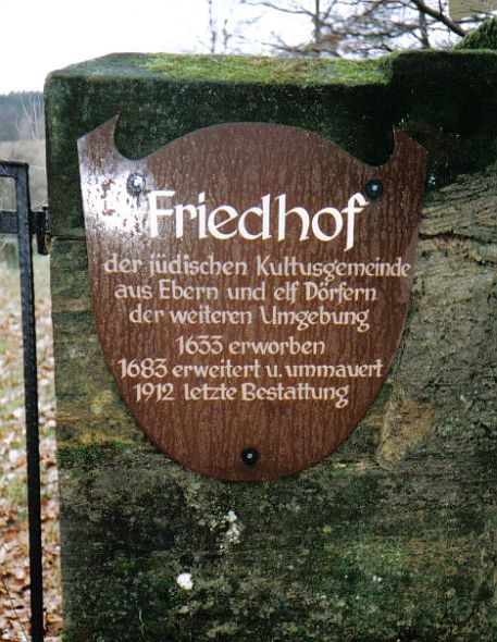
| Description | : | The cemetery is hidden away in front of the city in a side valley and served as the central funeral place for the surrounding Jewish communities. The cemetery is located northeast of the premises of the FTE automotive on the slope of the Steinberg. The approximately 132.50 Ar area is partially surrounded by a 1.50 meter high sandstone wall. The modern wrought-iron entrance gate is closed for security reasons. The key is issued by the city administration. Today there are still about 1200 tombstones preserved, which are almost exclusively inscribed in Hebrew because of the orthodox orientation of the surrounding... Read More |
frequently asked questions (FAQ):
-
Where is Ebern Friedhof?
Ebern Friedhof is located at 6 Bahnhofstrasse Bamberg, Stadtkreis Bamberg ,Bavaria (Bayern) ,Germany.
-
Ebern Friedhof cemetery's updated grave count on graveviews.com?
0 memorials
-
Where are the coordinates of the Ebern Friedhof?
Latitude: 50.0980052
Longitude: 10.7917598
Nearby Cemetories:
1. Friedhof Kirchlauter
Kirchlauter, Landkreis Haßberge, Germany
Coordinate: 50.0439500, 10.7189520
2. Friedhof
Bad Staffelstein, Landkreis Lichtenfels, Germany
Coordinate: 50.1003539, 11.0053466
3. Friedhof Breitengüßbach
Breitengussbach, Landkreis Bamberg, Germany
Coordinate: 49.9720510, 10.8879620
4. Friedhof Königsberg in Bayern
Königsberg in Bayern, Landkreis Haßberge, Germany
Coordinate: 50.0841497, 10.5698521
5. Jewish Cemetery
Ermershausen, Landkreis Haßberge, Germany
Coordinate: 50.2041483, 10.6372784
6. Friedhof Prappach
Prappach, Landkreis Haßberge, Germany
Coordinate: 50.0520817, 10.5635309
7. Friedhof Ermershausen (bei Haßfurt)
Ermershausen, Landkreis Haßberge, Germany
Coordinate: 50.2091042, 10.6212376
8. Friedhof Schweinshaupten
Schweinshaupten, Landkreis Haßberge, Germany
Coordinate: 50.1869689, 10.5731992
9. Friedhof Sand am Main
Sand am Main, Landkreis Haßberge, Germany
Coordinate: 49.9865744, 10.5928441
10. Friedhof
Uetzing, Landkreis Lichtenfels, Germany
Coordinate: 50.0877961, 11.0642177
11. Friedhof Hofheim in Unterfranken
Hofheim in Unterfranken, Landkreis Haßberge, Germany
Coordinate: 50.1345930, 10.5241565
12. Friedhof Hallstadt
Hallstadt, Landkreis Bamberg, Germany
Coordinate: 49.9250640, 10.8772800
13. Friedhof Weidach
Weidach, Landkreis Coburg, Germany
Coordinate: 50.2634919, 10.9095734
14. Friedhof Haßfurt
Haßfurt, Landkreis Haßberge, Germany
Coordinate: 50.0397980, 10.5224710
15. Neuer Friedhof Haßfurt
Haßfurt, Landkreis Haßberge, Germany
Coordinate: 50.0397367, 10.5219652
16. Lichtenfels
Lichtenfels, Landkreis Lichtenfels, Germany
Coordinate: 50.1447496, 11.0707145
17. Alter Friedhof Haßfurt
Haßfurt, Landkreis Haßberge, Germany
Coordinate: 50.0321433, 10.5127548
18. Ritterkapelle
Haßfurt, Landkreis Haßberge, Germany
Coordinate: 50.0318779, 10.5116408
19. Friedhof Fasanerie
Memmelsdorf, Landkreis Bamberg, Germany
Coordinate: 49.9294300, 10.9392200
20. Glockenberg Cemetery
Coburg, Stadtkreis Coburg, Germany
Coordinate: 50.2538970, 10.9723160
21. Morizkirche
Coburg, Stadtkreis Coburg, Germany
Coordinate: 50.2572220, 10.9661110
22. Veste Helberg
Landkreis Hildburghausen, Germany
Coordinate: 50.2888940, 10.7287120
23. Friedhof Callenberg
Callenberg, Stadtkreis Coburg, Germany
Coordinate: 50.2760107, 10.9205062
24. Saint Augustin's Church
Coburg, Stadtkreis Coburg, Germany
Coordinate: 50.2604420, 10.9685940