
| Memorials | : | 0 |
| Location | : | Coldwater, Tate County, USA |
| Coordinate | : | 34.6847100, -89.9618800 |
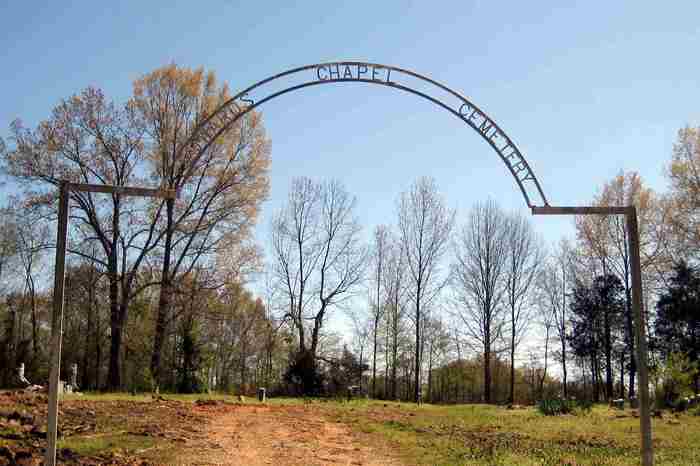
| Description | : | From the intersection of Peyton Rd. & US-51, in Coldwater, travel east on Peyton Rd. for 1.0 mi.; turning south (right) into the driveway, which is due south of the intersection of Sandridge Rd. with Peyton Rd., of this large, well-maintained 'deeded' cemetery, as notated on USGS topo maps. This cemetery adjoining the western boundary of the Methodist Cemetery. (Note: USGS map depicts this cem. incorrectly swapped w/ the 'Methodist Cem.) Posted picture from 2009, shows the old iron arched sign above the entrance road, with the name "Edwards Chapel Cemetery". Google Map's 'Street View' shows this sign in... Read More |
frequently asked questions (FAQ):
-
Where is Edwards Chapel Cemetery?
Edwards Chapel Cemetery is located at 1000 Peyton Road Coldwater, Tate County ,Mississippi ,USA.
-
Edwards Chapel Cemetery cemetery's updated grave count on graveviews.com?
0 memorials
-
Where are the coordinates of the Edwards Chapel Cemetery?
Latitude: 34.6847100
Longitude: -89.9618800
Nearby Cemetories:
1. Methodist Cemetery
Coldwater, Tate County, USA
Coordinate: 34.6844710, -89.9596250
2. Magnolia Cemetery
Coldwater, Tate County, USA
Coordinate: 34.6989420, -89.9568420
3. Anderson Cemetery
Tate County, USA
Coordinate: 34.6703000, -89.9671000
4. Buntin Cemetery
Coldwater, Tate County, USA
Coordinate: 34.6671982, -89.9441986
5. Bethel Cemetery
Coldwater, Tate County, USA
Coordinate: 34.6631012, -89.9408035
6. Prichard Cemetery
Coldwater, Tate County, USA
Coordinate: 34.7028510, -89.9353930
7. Liberty Church Cemetery
Coldwater, Tate County, USA
Coordinate: 34.6993910, -89.9202070
8. Eavenson Cemetery
Coldwater, Tate County, USA
Coordinate: 34.6765020, -89.9113860
9. Cameron Road Jehovah Witness Cemetery
Coldwater, Tate County, USA
Coordinate: 34.6591845, -90.0048373
10. Hills Chapel Cemetery
Coldwater, Tate County, USA
Coordinate: 34.6551400, -90.0031600
11. Strickland Cemetery
Coldwater, Tate County, USA
Coordinate: 34.6929800, -89.9079700
12. Highway 51 Cemetery
Senatobia, Tate County, USA
Coordinate: 34.6346790, -89.9684220
13. Perry Cemetery
DeSoto County, USA
Coordinate: 34.7334950, -89.9880360
14. McAninch Family Cemetery
Love, DeSoto County, USA
Coordinate: 34.7342500, -89.9880830
15. LeSure Cemetery
Coldwater, Tate County, USA
Coordinate: 34.6924070, -89.8948280
16. Love Family Cemetery
Hernando, DeSoto County, USA
Coordinate: 34.7457610, -89.9764740
17. Scotland Cemetery
Antioch, Tate County, USA
Coordinate: 34.7147910, -89.8951430
18. Brooks Chapel Cemetery
Arkabutla, Tate County, USA
Coordinate: 34.6706650, -90.0388020
19. McLeod Cemetery
Antioch, Tate County, USA
Coordinate: 34.7133270, -89.8907720
20. Antioch M.B Church Cemetery #1
Coldwater, Tate County, USA
Coordinate: 34.6414140, -90.0212140
21. Antioch M.B. Church Cemetery #2
Coldwater, Tate County, USA
Coordinate: 34.6852450, -90.0432750
22. Solomon Cemetery
Hernando, DeSoto County, USA
Coordinate: 34.7281240, -90.0259670
23. Ebenezer Church Cemetery
Senatobia, Tate County, USA
Coordinate: 34.6257690, -90.0044860
24. Hickory Grove M.B. Church Cemetery
Senatobia, Tate County, USA
Coordinate: 34.6489910, -89.8891830