
| Memorials | : | 0 |
| Location | : | Gondelsheim, Landkreis Bitburg-Prüm, Germany |
| Coordinate | : | 50.2330753, 6.5052219 |
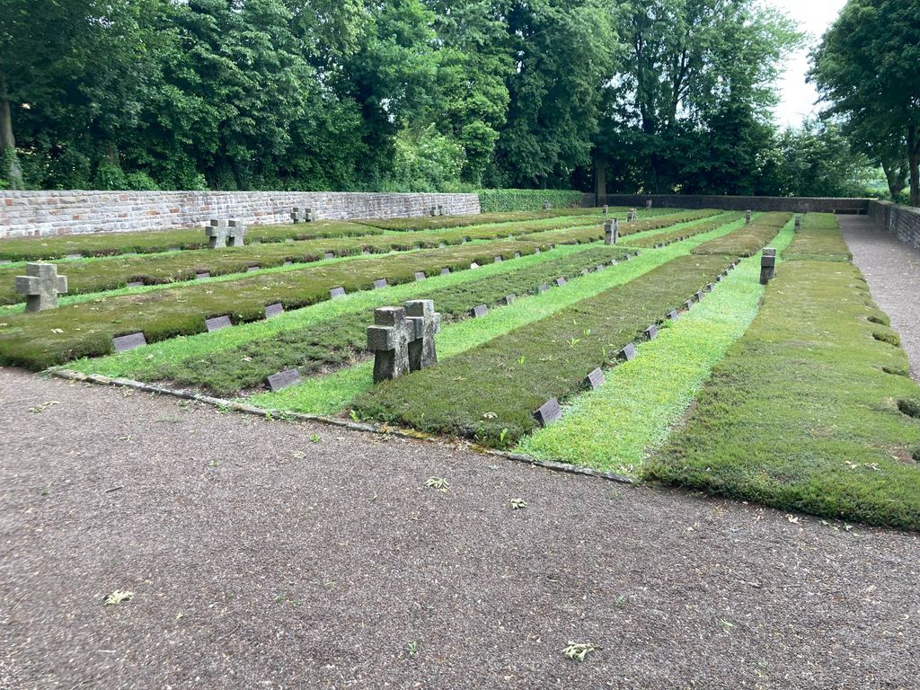
| Description | : | Der Ehrenfriedhof wurde bereits 1945 angelegt, um die gefallenen Soldaten des Zweiten Weltkrieges zu beerdigen. In seiner jetzigen Form existiert er seit 1958, mit der damals eingeweihten Gräberstätte |
frequently asked questions (FAQ):
-
Where is Ehrenfriedhof Gondelsheim?
Ehrenfriedhof Gondelsheim is located at Gondelsheim, Landkreis Bitburg-Prüm ,Rheinland-Pfalz ,Germany.
-
Ehrenfriedhof Gondelsheim cemetery's updated grave count on graveviews.com?
0 memorials
-
Where are the coordinates of the Ehrenfriedhof Gondelsheim?
Latitude: 50.2330753
Longitude: 6.5052219
Nearby Cemetories:
1. Friedhof St. Margarethe
Schwirzheim, Landkreis Bitburg-Prüm, Germany
Coordinate: 50.2359154, 6.5303784
2. Friedhof St. Lukas
Fleringen, Landkreis Bitburg-Prüm, Germany
Coordinate: 50.2086210, 6.4983377
3. Prüm Abbey
Landkreis Bitburg-Prüm, Germany
Coordinate: 50.2064000, 6.4257000
4. Bestattungswald Kalvarienberg
Prüm, Landkreis Bitburg-Prüm, Germany
Coordinate: 50.2101418, 6.4129266
5. Friedhof St. Gordian und Epimachus
Niederprüm, Landkreis Bitburg-Prüm, Germany
Coordinate: 50.1962379, 6.4121564
6. Friedhof St. Martin
Niederlauch, Landkreis Bitburg-Prüm, Germany
Coordinate: 50.1623240, 6.4277460
7. St. Margaretha Friedhof
Lissingen, Landkreis Vulkaneifel, Germany
Coordinate: 50.2143159, 6.6374492
8. Bestattungswald Gerolstein
Gerolstein, Landkreis Vulkaneifel, Germany
Coordinate: 50.2101759, 6.6589835
9. Friedhof Watzerath
Watzerath, Landkreis Bitburg-Prüm, Germany
Coordinate: 50.1839509, 6.3550878
10. Bestattungswald Jünkerath
Junkerath, Landkreis Vulkaneifel, Germany
Coordinate: 50.3442920, 6.5615232
11. Friedhof Pronsfeld
Pronsfeld, Landkreis Bitburg-Prüm, Germany
Coordinate: 50.1602949, 6.3520215
12. Kriegsgäberstätte Auw
Auw bei Prüm, Landkreis Bitburg-Prüm, Germany
Coordinate: 50.3023090, 6.3400990
13. St Agathakirk
Berlingen, Landkreis Vulkaneifel, Germany
Coordinate: 50.2408330, 6.7205560
14. Friedhof Neidenbach
Neidenbach, Landkreis Bitburg-Prüm, Germany
Coordinate: 50.0937181, 6.5473729
15. Friedhof Oberstadtfeld
Oberstadtfeld, Landkreis Vulkaneifel, Germany
Coordinate: 50.1745903, 6.7648483
16. Schleid
Schleid, Landkreis Bitburg-Prüm, Germany
Coordinate: 50.0562000, 6.4934800
17. St. Maximin Friedhof - Kyllburg
Landkreis Bitburg-Prüm, Germany
Coordinate: 50.0387170, 6.5876330
18. Stifts Kirche - Kyllburg
Landkreis Bitburg-Prüm, Germany
Coordinate: 50.0357000, 6.5859670
19. Begräbniswald Niederweiler
Niederweiler, Landkreis Bitburg-Prüm, Germany
Coordinate: 50.0328880, 6.4308070
20. Wereth 11 Memorial Site
Amel, Arrondissement de Verviers, Belgium
Coordinate: 50.3486990, 6.2312650
21. Friedhof Hünningen
Hünningen, Arrondissement de Verviers, Belgium
Coordinate: 50.3965315, 6.2955881
22. Weinfelder Friedhof
Schalkenmehren, Landkreis Vulkaneifel, Germany
Coordinate: 50.1789544, 6.8493504
23. Friedhof Oberkail
Oberkail, Landkreis Bitburg-Prüm, Germany
Coordinate: 50.0346016, 6.6798981
24. Friedhof Bullingen
Büllingen, Arrondissement de Verviers, Belgium
Coordinate: 50.4039573, 6.2501203