
| Memorials | : | 42 |
| Location | : | Palmer, Pocahontas County, USA |
| Phone | : | (712) 359-2206 |
| Coordinate | : | 42.6169014, -94.6875000 |
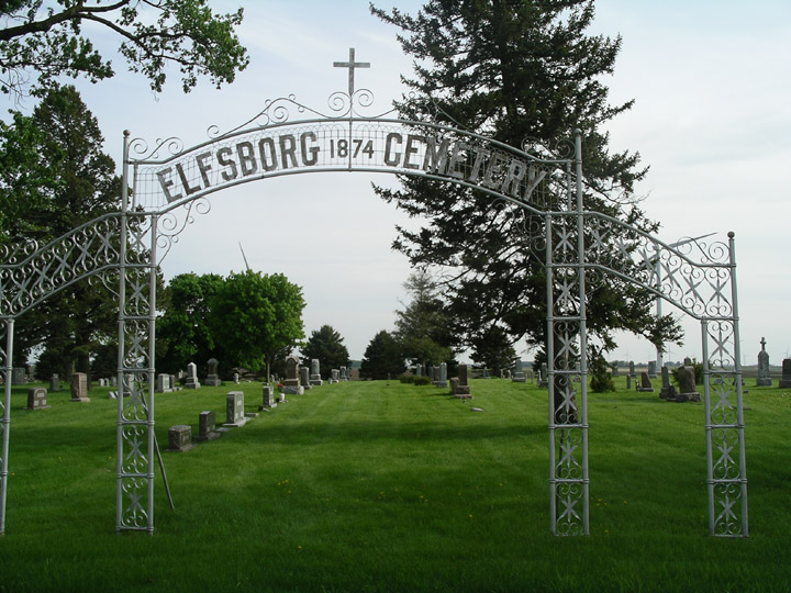
| Description | : | The cemetery is located in Colfax Township on the south side of 600th Street about 0.5 miles west of its intersection with 220th Avenue (Iowa State Highway 4). The U.S. Geological Survey (USGS) Geographic Names Information System (GNIS) feature ID for the cemetery is 1925414 (Elfsborg Lutheran Cemetery). |
frequently asked questions (FAQ):
-
Where is Elfsborg Lutheran Cemetery?
Elfsborg Lutheran Cemetery is located at 600th Street Palmer, Pocahontas County ,Iowa , 50575USA.
-
Elfsborg Lutheran Cemetery cemetery's updated grave count on graveviews.com?
42 memorials
-
Where are the coordinates of the Elfsborg Lutheran Cemetery?
Latitude: 42.6169014
Longitude: -94.6875000
Nearby Cemetories:
1. Evangelical Covenant Cemetery
Pomeroy, Calhoun County, USA
Coordinate: 42.6165720, -94.6803640
2. Swedish Mission Bethany Cemetery
Pocahontas County, USA
Coordinate: 42.6138992, -94.6774979
3. Grant Township Cemetery
Pocahontas, Pocahontas County, USA
Coordinate: 42.6571999, -94.6996994
4. Saint Josephs Cemetery
Palmer, Pocahontas County, USA
Coordinate: 42.6342010, -94.6188965
5. Saint Marys Catholic Cemetery
Pomeroy, Calhoun County, USA
Coordinate: 42.5558014, -94.6889038
6. Union Cemetery
Pomeroy, Calhoun County, USA
Coordinate: 42.5539017, -94.6789017
7. Palmer Cemetery
Palmer, Pocahontas County, USA
Coordinate: 42.6166992, -94.5894012
8. Saint Paul Lutheran Cemetery
Palmer, Pocahontas County, USA
Coordinate: 42.6176000, -94.5893500
9. Swedish Cemetery
Manson, Calhoun County, USA
Coordinate: 42.5426295, -94.5992013
10. Memorial Park Cemetery
Calhoun County, USA
Coordinate: 42.5189018, -94.6194000
11. Mount Zion Cemetery
Fonda, Pocahontas County, USA
Coordinate: 42.5821991, -94.8300018
12. Cedar Township Cemetery
Fonda, Pocahontas County, USA
Coordinate: 42.5810000, -94.8375000
13. Summit Hill Cemetery
Pocahontas, Pocahontas County, USA
Coordinate: 42.7315000, -94.6595000
14. Calvary Cemetery
Pocahontas, Pocahontas County, USA
Coordinate: 42.7335000, -94.6597000
15. Saint Columbkilles Cemetery
Varina, Pocahontas County, USA
Coordinate: 42.6467018, -94.8443985
16. Saint Paul Lutheran Cemetery
Pocahontas County, USA
Coordinate: 42.5610000, -94.5392000
17. Saint Johns Lutheran Cemetery
Palmer, Pocahontas County, USA
Coordinate: 42.6268997, -94.5205994
18. Crown Hill Cemetery
Jolley, Calhoun County, USA
Coordinate: 42.4808006, -94.7360992
19. Dover Township Cemetery
Varina, Pocahontas County, USA
Coordinate: 42.6896100, -94.8524200
20. Saint Thomas Cemetery
Manson, Calhoun County, USA
Coordinate: 42.5208500, -94.5365000
21. Rose Hill Cemetery
Manson, Calhoun County, USA
Coordinate: 42.5228004, -94.5243988
22. Lizard Cemetery
Palmer, Pocahontas County, USA
Coordinate: 42.5875015, -94.4796982
23. Leith Cemetery
Manson, Calhoun County, USA
Coordinate: 42.4878006, -94.5667038
24. Hope Cemetery
Manson, Calhoun County, USA
Coordinate: 42.4994011, -94.5199966