
| Memorials | : | 0 |
| Location | : | Fairfield County, USA |
| Coordinate | : | 34.2925000, -81.0997220 |
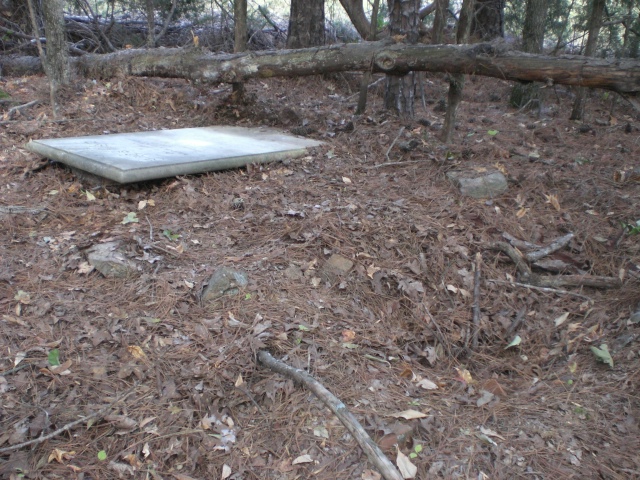
| Description | : | North side of W. Peach Road and left of high tension power line R/W - 40' into the woods. Following the power line, the distance is 0.34 mi (1800 ft) walking northwest from Peach Rd. There is only one marked tombstone here (Elisha Haygood), along with an undetermined number (6-8-10) of unmarked graves with plain fieldstones. This is on private property and it is necessary to cross thru barbed wire fences which extend across the power line R/W. Sometime between 2011 and 2015, the tablet for Elisha Haygood has been damaged by logging operations. It's shown in one piece here, but is... Read More |
frequently asked questions (FAQ):
-
Where is Elisha Haygood Family Cemetery?
Elisha Haygood Family Cemetery is located at off W. Peach Road (S-20-30) Fairfield County ,South Carolina ,USA.
-
Elisha Haygood Family Cemetery cemetery's updated grave count on graveviews.com?
0 memorials
-
Where are the coordinates of the Elisha Haygood Family Cemetery?
Latitude: 34.2925000
Longitude: -81.0997220
Nearby Cemetories:
1. Broom Family Cemetery
Fairfield County, USA
Coordinate: 34.2686110, -81.0816670
2. New Buffalo Cemetery
Fairfield County, USA
Coordinate: 34.2667007, -81.0671997
3. Molly Alston Cemetery
Fairfield County, USA
Coordinate: 34.2630997, -81.1382980
4. Buffalo Baptist Church Cemetery
Fairfield County, USA
Coordinate: 34.2426080, -81.0743680
5. Old Horeb Presbyterian Church Site
Jenkinsville, Fairfield County, USA
Coordinate: 34.2622500, -81.1638200
6. Mount Zion African Methodist Episcopal Church Cemetery
Fairfield County, USA
Coordinate: 34.2744500, -81.1716670
7. Burrel Burying Ground
Fairfield County, USA
Coordinate: 34.2601300, -81.1693500
8. Nathaniel Mann Cemetery
Fairfield County, USA
Coordinate: 34.2586100, -81.1710200
9. Fairfield Baptist Church Cemetery
Fairfield County, USA
Coordinate: 34.3544000, -81.1400000
10. Crooked Run Baptist Church Cemetery
Jennings, Fairfield County, USA
Coordinate: 34.2373460, -81.1549200
11. Irby Cemetery
Fairfield County, USA
Coordinate: 34.2641800, -81.1847300
12. Cork-Murphy Cemetery
Jenkinsville, Fairfield County, USA
Coordinate: 34.2877780, -81.1958520
13. Broom Family Cemetery
Blythewood, Richland County, USA
Coordinate: 34.2227780, -81.0469440
14. Lyles Family Cemetery
Jenkinsville, Fairfield County, USA
Coordinate: 34.2433300, -81.1806700
15. Blanks Family Farm Cemetery
Blythewood, Richland County, USA
Coordinate: 34.2256050, -81.0372420
16. Mann Cemetery
Fairfield County, USA
Coordinate: 34.2346992, -81.1761017
17. Craig-Kennedy Family Cemetery
Fairfield County, USA
Coordinate: 34.2850000, -80.9950000
18. Beulah United Methodist Church Cemetery
Blythewood, Richland County, USA
Coordinate: 34.2075005, -81.0643997
19. Milling Crossroad Cemetery
Fairfield County, USA
Coordinate: 34.3567009, -81.1781006
20. Harmon-Kennedy-Rosborough Cemetery
Fairfield County, USA
Coordinate: 34.2752870, -80.9911570
21. Gibson Cemetery
Jennings, Fairfield County, USA
Coordinate: 34.2453003, -81.2052994
22. Martin - Aiken Burial Ground
Lebanon, Fairfield County, USA
Coordinate: 34.3690500, -81.1785170
23. Saint Matthews First Baptist Church Cemetery
Jennings, Fairfield County, USA
Coordinate: 34.2539350, -81.2149320
24. Cedar Creek Methodist Church Cemetery
Cedar Creek, Richland County, USA
Coordinate: 34.1893005, -81.1225967