
| Memorials | : | 14 |
| Location | : | Emlenton, Venango County, USA |
| Coordinate | : | 41.1834900, -79.7133700 |
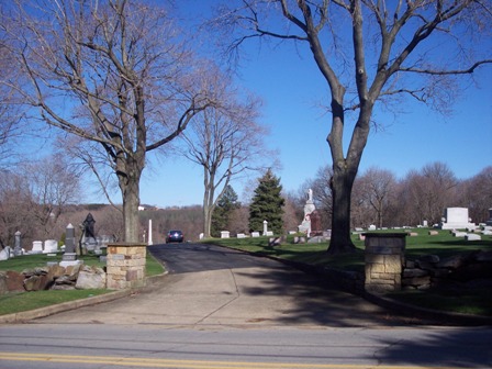
| Description | : | There are 3 separate Cemeteries in Emlenton. Crawford Memorial Cemetery, Emlenton Cemetery and St Michael Arch Angel.. Coordinates: 041º 11' 00.7" N. 079º 42' 49.3" W From Franklin follow Route 322 East through Cranberry and on through Van. Turn right on Route 38 and go approximately 8.2 miles to where SR 2001 branches off to the right. Take SR 2001 for approximately 3.5 miles. The cemetery is on the right side of the road, before descending the hill. |
frequently asked questions (FAQ):
-
Where is Emlenton Cemetery?
Emlenton Cemetery is located at Emlenton, Venango County ,Pennsylvania ,USA.
-
Emlenton Cemetery cemetery's updated grave count on graveviews.com?
13 memorials
-
Where are the coordinates of the Emlenton Cemetery?
Latitude: 41.1834900
Longitude: -79.7133700
Nearby Cemetories:
1. Big Bend Cemetery
Emlenton, Venango County, USA
Coordinate: 41.2009200, -79.7422600
2. Memorial Episcopal Church of Our Father Cemetery
Foxburg, Clarion County, USA
Coordinate: 41.1455590, -79.6805660
3. Zion Union Cemetery
Emlenton, Venango County, USA
Coordinate: 41.2193000, -79.6747000
4. Mount Pleasant Cemetery
Mariasville, Venango County, USA
Coordinate: 41.2132000, -79.6651000
5. Scrubgrass Presbyterian Cemetery
Emlenton, Venango County, USA
Coordinate: 41.1743546, -79.7754211
6. Saint Petersburg Cemetery
Saint Petersburg, Clarion County, USA
Coordinate: 41.1615000, -79.6505000
7. Richland Presbyterian Cemetery
Clarion County, USA
Coordinate: 41.2087740, -79.6486490
8. Allegheny Church Cemetery
Butler County, USA
Coordinate: 41.1233000, -79.7095000
9. East Unity Cemetery
Cherry Valley, Butler County, USA
Coordinate: 41.1689987, -79.7965927
10. Chestnut Ridge Cemetery
Clarion County, USA
Coordinate: 41.1856003, -79.6243973
11. Salem United Church of Christ Cemetery
Lamartine, Clarion County, USA
Coordinate: 41.2210220, -79.6337690
12. Salem Lutheran Church Cemetery
Lamartine, Clarion County, USA
Coordinate: 41.2248438, -79.6293783
13. Bickle Cemetery
Rockland Township, Venango County, USA
Coordinate: 41.2613983, -79.7244034
14. Old Eau Claire Farmington ME Church Cemetery
Eau Claire, Butler County, USA
Coordinate: 41.1371994, -79.7979965
15. Farren Cemetery
Rockland Township, Venango County, USA
Coordinate: 41.2613983, -79.7288971
16. Eau Claire Cemetery
Eau Claire, Butler County, USA
Coordinate: 41.1286011, -79.8050003
17. Rockland Cemetery
Rockland, Venango County, USA
Coordinate: 41.2717018, -79.7457962
18. Hillard Farm Cemetery
Eau Claire, Butler County, USA
Coordinate: 41.1199989, -79.8010178
19. Perryville Cemetery
Perryville, Clarion County, USA
Coordinate: 41.0993000, -79.6627000
20. Saint Mark's United Church of Christ Cemetery
Monroe, Clarion County, USA
Coordinate: 41.1962000, -79.5903000
21. Parker Presbyterian Cemetery
Parker, Armstrong County, USA
Coordinate: 41.0914612, -79.6856232
22. Pisgah Cemetery
Murrinsville, Butler County, USA
Coordinate: 41.1533084, -79.8332868
23. Crossroads Cemetery
Clarion County, USA
Coordinate: 41.2529000, -79.6266000
24. GAR Cemetery
Parker, Armstrong County, USA
Coordinate: 41.0906000, -79.6838000