
| Memorials | : | 0 |
| Location | : | West Alexandria, Preble County, USA |
| Coordinate | : | 39.7038994, -84.5000000 |
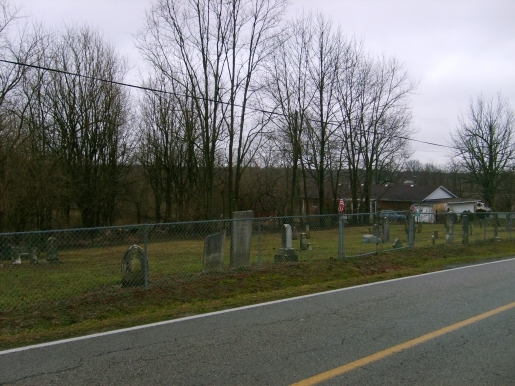
| Description | : | The cemetery is located on the east side of Enterprise Road (County Road 58) about 0.3 miles south of its intersection with Halderman Road (County Road 97). The cemetery is located in Lanier Township, Preble County, Ohio, and is # 10020 (Enterprise Cemetery / Guntle Cemetery / Ingomar Cemetery) in “Ohio Cemeteries 1803-2003”, compiled by the Ohio Genealogical Society. The cemetery is registered with the Ohio Division of Real Estate and Professional Licensing (ODRE) as Enterprise Cemetery with registration license number CGR.0000980364. The U.S. Geological Survey (USGS) Geographic Names Information System (GNIS) feature ID for the cemetery is... Read More |
frequently asked questions (FAQ):
-
Where is Enterprise Cemetery?
Enterprise Cemetery is located at Enterprise Road (County Road 58) West Alexandria, Preble County ,Ohio , 45381USA.
-
Enterprise Cemetery cemetery's updated grave count on graveviews.com?
0 memorials
-
Where are the coordinates of the Enterprise Cemetery?
Latitude: 39.7038994
Longitude: -84.5000000
Nearby Cemetories:
1. Willson Cemetery
Ingomar, Preble County, USA
Coordinate: 39.7042150, -84.5252040
2. Stiver Cemetery
Montgomery County, USA
Coordinate: 39.6848150, -84.4790750
3. Brower Cemetery
Enterprise, Preble County, USA
Coordinate: 39.6789200, -84.4991970
4. Clemmer Cemetery
Enterprise, Preble County, USA
Coordinate: 39.7050740, -84.5338730
5. Swinehart Cemetery
Preble County, USA
Coordinate: 39.6750970, -84.5149000
6. Eby Cemetery
County Line, Preble County, USA
Coordinate: 39.7329230, -84.4844740
7. United Brethren Cemetery
Wheatville, Preble County, USA
Coordinate: 39.6833610, -84.5316390
8. Van Ausdal Cemetery
West Alexandria, Preble County, USA
Coordinate: 39.7295620, -84.5281930
9. Sugar Hill Cemetery
West Alexandria, Preble County, USA
Coordinate: 39.7350006, -84.5166626
10. Henderson Grave
Farmersville, Montgomery County, USA
Coordinate: 39.6723460, -84.4778470
11. Fairview Cemetery
West Alexandria, Preble County, USA
Coordinate: 39.7350006, -84.5338974
12. Brower Cemetery
West Alexandria, Preble County, USA
Coordinate: 39.7287750, -84.5473480
13. Twin Valley Cemetery
Gratis, Preble County, USA
Coordinate: 39.6589012, -84.4985962
14. Old Town Cemetery
West Alexandria, Preble County, USA
Coordinate: 39.7434980, -84.5287260
15. Miller Cemetery
Johnsville, Montgomery County, USA
Coordinate: 39.7370580, -84.4524160
16. Pontius Cemetery
Farmersville, Montgomery County, USA
Coordinate: 39.6565000, -84.4765000
17. Landis Cemetery
Gratis, Preble County, USA
Coordinate: 39.6530560, -84.4834230
18. Ray Cemetery
Gratis, Preble County, USA
Coordinate: 39.6575539, -84.5427273
19. Young Family Cemetery
Gratis, Preble County, USA
Coordinate: 39.6573200, -84.5427770
20. Gratis Cemetery
Gratis, Preble County, USA
Coordinate: 39.6489470, -84.5308220
21. Warvel Cemetery
New Lebanon, Montgomery County, USA
Coordinate: 39.7494010, -84.4492440
22. Farmersville United Brethren Cemetery
Farmersville, Montgomery County, USA
Coordinate: 39.6789400, -84.4291100
23. Eikenberry Cemetery
Wheatville, Preble County, USA
Coordinate: 39.6852760, -84.5749969
24. Fairview Cemetery
Gratis, Preble County, USA
Coordinate: 39.6500015, -84.5361023