
| Memorials | : | 0 |
| Location | : | Sevier County, USA |
| Coordinate | : | 35.9755630, -83.5543060 |
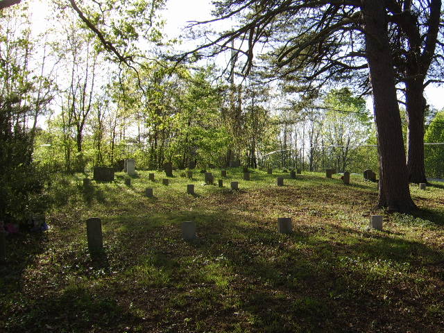
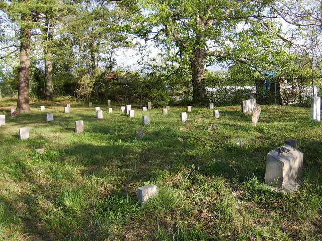
| Description | : | Cemetery is on top of a hill with a chain-link fence around it and does not have any signs. Take I40 either north or south and take exit 407 (Sevierville, Pigeon Forge, Gatlinburg). Take Rte 66 (Winfield Dunn Parkway) south towards Sevierville; go 2 miles and turn left onto Rte 139 east (Douglas Dam Road) (next to Lee Market/Gas Station) towards Danridge/Douglas Dam; go approx 3 miles; turn left onto Mutton Hollow Rd (next to French Broad Valley Baptist Church); go 4/10th mile; turn right (2nd right) onto Eslinger Ct; go approx. 300 feet; take road on right to fenced... Read More |
frequently asked questions (FAQ):
-
Where is Eslinger Cemetery?
Eslinger Cemetery is located at Sevier County ,Tennessee ,USA.
-
Eslinger Cemetery cemetery's updated grave count on graveviews.com?
0 memorials
-
Where are the coordinates of the Eslinger Cemetery?
Latitude: 35.9755630
Longitude: -83.5543060
Nearby Cemetories:
1. Thompson Cemetery
Jefferson County, USA
Coordinate: 35.9844017, -83.5468979
2. Underwood Cemetery
Kodak, Sevier County, USA
Coordinate: 35.9693985, -83.5669022
3. Acuff Cemetery
Jefferson County, USA
Coordinate: 35.9906006, -83.5532990
4. Fain Cemetery
Dandridge, Jefferson County, USA
Coordinate: 35.9878006, -83.5307999
5. Dumplin Cemetery
New Market, Jefferson County, USA
Coordinate: 36.0017014, -83.5567017
6. Hardin Cemetery
Sevierville, Sevier County, USA
Coordinate: 35.9495410, -83.5471090
7. Bryan Cemetery
Sevier County, USA
Coordinate: 35.9883003, -83.5832977
8. Thomas Cate Burial Site
Sevier County, USA
Coordinate: 35.9512596, -83.5732117
9. Cate Cemetery
New Market, Jefferson County, USA
Coordinate: 36.0038986, -83.5736008
10. Old McMahan Cemetery
Jefferson County, USA
Coordinate: 35.9571991, -83.5130997
11. Deep Springs Cemetery
Jefferson County, USA
Coordinate: 35.9961014, -83.5130997
12. Mount Cemetery
Sevier County, USA
Coordinate: 35.9682999, -83.6018982
13. Henrys Crossroads United Methodist Church Cemetery
Kodak, Sevier County, USA
Coordinate: 35.9561005, -83.5967026
14. Stockton Family Burying Grounds
Kodak, Sevier County, USA
Coordinate: 35.9354490, -83.5602475
15. Grahl Cemetery
Jefferson County, USA
Coordinate: 36.0050011, -83.5183029
16. Saffell Cemetery
Sevier County, USA
Coordinate: 35.9350014, -83.5674973
17. Hill Cemetery
Sevier County, USA
Coordinate: 35.9318275, -83.5460663
18. Oak Grove Cemetery
Kodak, Sevier County, USA
Coordinate: 35.9878006, -83.6106033
19. Ellis Cemetery
Catlettsburg, Sevier County, USA
Coordinate: 35.9324989, -83.5783005
20. French Cemetery
Jefferson County, USA
Coordinate: 36.0102997, -83.5089035
21. Atchley Isaac Graveyard
Sevierville, Sevier County, USA
Coordinate: 35.9252440, -83.5622580
22. Providence Cemetery
Sevier County, USA
Coordinate: 35.9247017, -83.5361023
23. Piedmont Cemetery
Piedmont, Jefferson County, USA
Coordinate: 36.0264015, -83.5353012
24. Alder Branch Baptist Church Cemetery
Sevierville, Sevier County, USA
Coordinate: 35.9222717, -83.5544128