
| Memorials | : | 0 |
| Location | : | Fresno County, USA |
| Coordinate | : | 36.5012400, -120.2653910 |
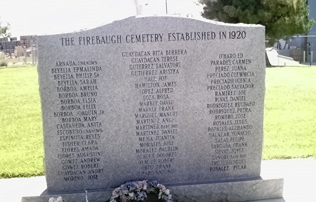
| Description | : | Firebaugh Cemetery Memorial 2502 N St Firebaugh Fresno County California USA The Firebaugh Cemetery was once located on private property, then owned by the City of Firebaugh from 1981. In 1989 a memorial stone was erected at the site of the old cemetery with names engraved of those known to be buried there from the established date of 1920, however there were headstones for burials as early as 1905. The combination of early burials, those removed from Las Juntas Cemetery (now defunct), and burials in Firebaugh from 1920 to 1971 would total many more than the current 61 names engraved. 10/06/2013 Above information researched and provided by... Read More |
frequently asked questions (FAQ):
-
Where is Firebaugh Cemetery?
Firebaugh Cemetery is located at Fresno County ,California ,USA.
-
Firebaugh Cemetery cemetery's updated grave count on graveviews.com?
0 memorials
-
Where are the coordinates of the Firebaugh Cemetery?
Latitude: 36.5012400
Longitude: -120.2653910
Nearby Cemetories:
1. Harris Farms Horse Division Burial Site
Coalinga, Fresno County, USA
Coordinate: 36.3416400, -120.3006100
2. Dick Wright
Coalinga, Fresno County, USA
Coordinate: 36.3142452, -120.5319592
3. Las Juntas Cemetery
Firebaugh, Fresno County, USA
Coordinate: 36.7793800, -120.3720300
4. Golden Sunset Memorial Park
Kerman, Fresno County, USA
Coordinate: 36.7307700, -120.0414400
5. Raisin City Cemetery
Raisin City, Fresno County, USA
Coordinate: 36.5905500, -119.9043700
6. New Idria Cemetery
Idria, San Benito County, USA
Coordinate: 36.4132380, -120.6724580
7. Russian Molokan Cemetery
Kerman, Fresno County, USA
Coordinate: 36.8156840, -120.0724290
8. Pleasant Valley Cemetery
Coalinga, Fresno County, USA
Coordinate: 36.1504800, -120.2829100
9. Bethany Evangelical Lutheran Church Cemetery
Fresno County, USA
Coordinate: 36.8176003, -120.0721588
10. Anderson Akers Cemetery
Coalinga, Fresno County, USA
Coordinate: 36.2642690, -120.6226220
11. Fresno Memorial Gardens
Fresno, Fresno County, USA
Coordinate: 36.7330590, -119.8810050
12. Taylor Cemetery
Lemoore, Kings County, USA
Coordinate: 36.3207180, -119.8346310
13. Saint Peters Catholic Cemetery
Fresno, Fresno County, USA
Coordinate: 36.7400970, -119.8708496
14. Washington Colony Cemetery
Fresno, Fresno County, USA
Coordinate: 36.6294510, -119.7906090
15. Rhoads Cemetery
Kings County, USA
Coordinate: 36.3223170, -119.8120920
16. Oak Grove Cemetery
Laton, Fresno County, USA
Coordinate: 36.4468400, -119.7635000
17. New Hope Cemetery
Madera County, USA
Coordinate: 36.9089737, -120.1552200
18. Masis Ararat Cemetery
Fresno, Fresno County, USA
Coordinate: 36.7452030, -119.8354360
19. Sam Yup Cemetery
Fresno, Fresno County, USA
Coordinate: 36.7467330, -119.8367740
20. Fresno County Cemetery #2
Fresno, Fresno County, USA
Coordinate: 36.7474900, -119.8372470
21. Chinese Cemetery
Fresno, Fresno County, USA
Coordinate: 36.7475900, -119.8357100
22. Sunflower Fields Cemetery
Lemoore, Kings County, USA
Coordinate: 36.3322640, -119.7814320
23. Ararat Cemetery
Fresno, Fresno County, USA
Coordinate: 36.7487000, -119.8344900
24. Fresno Pet Cemetery
Fresno County, USA
Coordinate: 36.7423935, -119.8282242