
| Memorials | : | 0 |
| Location | : | Sartell, Stearns County, USA |
| Phone | : | (320) 251-0804 |
| Website | : | lovefirstumc.org/ |
| Coordinate | : | 45.6044480, -94.2328560 |
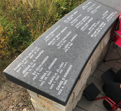
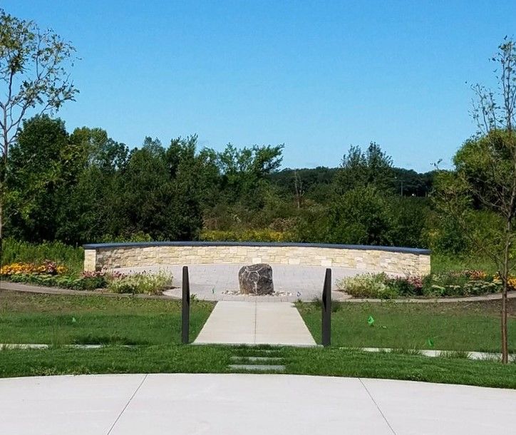
| Description | : | Decade-long project completed and dedicated in September 2019. "The sanctuary will allow all members of the community the option to have their loved ones’ name engraved on the wall, or ashes interred or scattered in the garden..." The whole garden is set within a restored native prairie and includes large and small trees for beauty and some shade. The memorial garden lies at the western edge of the church property. First interment took place in the fall of 2019. |
frequently asked questions (FAQ):
-
Where is First United Methodist Church Memorial Garden?
First United Methodist Church Memorial Garden is located at 1107 Pine Cone Road South Sartell, Stearns County ,Minnesota , 56377USA.
-
First United Methodist Church Memorial Garden cemetery's updated grave count on graveviews.com?
0 memorials
-
Where are the coordinates of the First United Methodist Church Memorial Garden?
Latitude: 45.6044480
Longitude: -94.2328560
Nearby Cemetories:
1. Saint Francis Xavier Cemetery
Sartell, Stearns County, USA
Coordinate: 45.6221275, -94.2142792
2. Oak Hill Cemetery
Sartell, Stearns County, USA
Coordinate: 45.6216927, -94.2125473
3. Saint Clares Monastery Mausoleum
Sauk Rapids, Benton County, USA
Coordinate: 45.5878690, -94.1586060
4. Pioneer Cemetery
Sauk Rapids, Benton County, USA
Coordinate: 45.5846410, -94.1535190
5. Sacred Heart Cemetery
Sauk Rapids, Benton County, USA
Coordinate: 45.5872002, -94.1513977
6. Stanger Cemetery
Saint Joseph, Stearns County, USA
Coordinate: 45.5508003, -94.2703018
7. Hilltop Mausoleum
Sauk Rapids, Benton County, USA
Coordinate: 45.5863900, -94.1512400
8. Saint Joseph Cemetery
Waite Park, Stearns County, USA
Coordinate: 45.5438995, -94.2300034
9. Benton County Cemetery
Sauk Rapids, Benton County, USA
Coordinate: 45.5853004, -94.1500015
10. Trinity Lutheran Cemetery
Sauk Rapids, Benton County, USA
Coordinate: 45.5867004, -94.1492004
11. Bethlehem Lutheran Church Columbarium
Saint Cloud, Stearns County, USA
Coordinate: 45.5398000, -94.2104300
12. Saint Joseph Cemetery
Saint Joseph, Stearns County, USA
Coordinate: 45.5617700, -94.3168300
13. Saint Benedicts Convent Cemetery
Saint Joseph, Stearns County, USA
Coordinate: 45.5610000, -94.3180000
14. North Star Cemetery
Saint Cloud, Stearns County, USA
Coordinate: 45.5386009, -94.1802979
15. Calvary Cemetery
Saint Cloud, Stearns County, USA
Coordinate: 45.5349998, -94.1757965
16. Brockway Cemetery
Stearns County, USA
Coordinate: 45.6889000, -94.2164001
17. Assumption Cemetery
Saint Cloud, Stearns County, USA
Coordinate: 45.5307999, -94.1650009
18. Staples Cemetery
Saint Joseph, Stearns County, USA
Coordinate: 45.5269012, -94.3007965
19. Davis Family Cemetery
Saint Joseph, Stearns County, USA
Coordinate: 45.5269000, -94.3008000
20. Saint Stephani Cemetery
Saint Stephen, Stearns County, USA
Coordinate: 45.7008100, -94.2748400
21. Reformatory Cemetery
Haven Township, Sherburne County, USA
Coordinate: 45.5412030, -94.1127980
22. Saint Columbkille Cemetery
Saint Wendel, Stearns County, USA
Coordinate: 45.6677830, -94.3675210
23. Saint Johns Abbey Friends Cemetery
Collegeville, Stearns County, USA
Coordinate: 45.5763000, -94.3956800
24. Saint John the Baptist Parish Cemetery
Collegeville, Stearns County, USA
Coordinate: 45.5760700, -94.3958000