
| Memorials | : | 0 |
| Location | : | Douglasville, Douglas County, USA |
| Coordinate | : | 33.7376610, -84.7788120 |
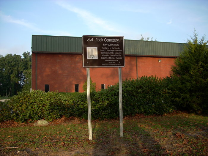
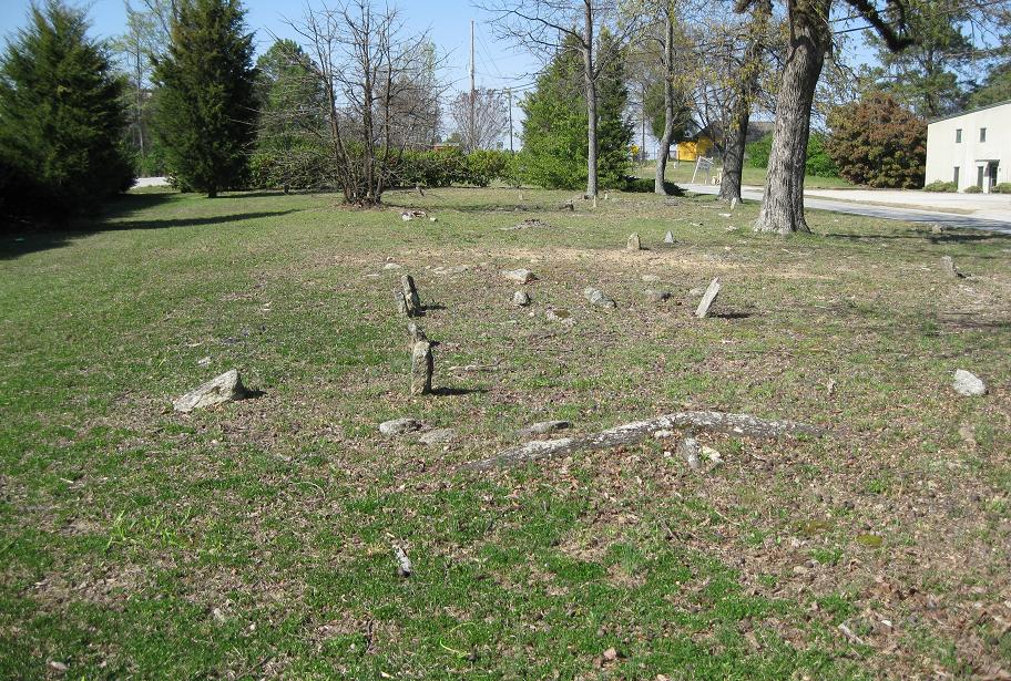
| Description | : | This cemetery is just south of Bankhead Highway, on the west side of Bright Star Road. It is sometimes referred to as the Flat Rock cemetery. This site was originally that of the antebellum home of John VanSant's family. A building on the site was used as a military hospital during the War of Northern Aggression, and it is believed that some of the graves marked only by fieldstones and laid out very haphazardly may date from its use as a hospital. The only engraved marker in the cemetery of perhaps 100 graves is that of a child in the... Read More |
frequently asked questions (FAQ):
-
Where is Flat Rock Cemetery?
Flat Rock Cemetery is located at Douglasville, Douglas County ,Georgia ,USA.
-
Flat Rock Cemetery cemetery's updated grave count on graveviews.com?
0 memorials
-
Where are the coordinates of the Flat Rock Cemetery?
Latitude: 33.7376610
Longitude: -84.7788120
Nearby Cemetories:
1. Ergle-Hix Cemetery
Douglasville, Douglas County, USA
Coordinate: 33.7391730, -84.7882320
2. Enterkin Family Cemetery
Douglasville, Douglas County, USA
Coordinate: 33.7217700, -84.7765800
3. Rosehaven Cemetery
Douglasville, Douglas County, USA
Coordinate: 33.7453600, -84.7535300
4. Douglasville City Cemetery
Douglasville, Douglas County, USA
Coordinate: 33.7473500, -84.7541100
5. Rice Family Cemetery
Douglas County, USA
Coordinate: 33.7170150, -84.7917110
6. Baggett Family Cemetery
Winston, Douglas County, USA
Coordinate: 33.7195313, -84.8005330
7. Smith Family Cemetery
Douglasville, Douglas County, USA
Coordinate: 33.7111590, -84.7745630
8. Harper-Hudson Cemetery
Douglasville, Douglas County, USA
Coordinate: 33.7659750, -84.7895300
9. Liberty Methodist Episcopal Church Cemetery
Douglasville, Douglas County, USA
Coordinate: 33.7543530, -84.7486210
10. Bright Star Cemetery
Douglasville, Douglas County, USA
Coordinate: 33.7053500, -84.7858400
11. Saint Julians Memorial Garden
Douglasville, Douglas County, USA
Coordinate: 33.7089388, -84.7516909
12. Central Baptist Church Memorial Garden
Douglasville, Douglas County, USA
Coordinate: 33.7029700, -84.7645500
13. Clinton Family Cemetery
Douglas County, USA
Coordinate: 33.7669980, -84.8068520
14. Old Mountain Top Cemetery
Winston, Douglas County, USA
Coordinate: 33.7382120, -84.8252890
15. Holdbrook Family Cemetery
Douglasville, Douglas County, USA
Coordinate: 33.6970230, -84.7814060
16. McLarty-Weddington Cemetery
Winston, Douglas County, USA
Coordinate: 33.7424600, -84.8278200
17. Bearden Church of Christ Cemetery
Douglasville, Douglas County, USA
Coordinate: 33.6962020, -84.7831580
18. Stewart-Winn Family Cemetery
Douglas County, USA
Coordinate: 33.7776450, -84.7636900
19. Entrekin-Winn Cemetery
Winston, Douglas County, USA
Coordinate: 33.7293000, -84.8287100
20. New Mountain Top Baptist Church Cemetery
Winston, Douglas County, USA
Coordinate: 33.7288890, -84.8312550
21. Carnes-Milam Cemetery
Douglas County, USA
Coordinate: 33.7014170, -84.8115190
22. McLarty Family Cemetery
Douglasville, Douglas County, USA
Coordinate: 33.7557945, -84.8303528
23. Polk Family Cemetery
Douglasville, Douglas County, USA
Coordinate: 33.7373760, -84.8407920
24. Sharpton Family Cemetery
Douglas County, USA
Coordinate: 33.7769890, -84.7365890