
| Memorials | : | 0 |
| Location | : | Franklin County, USA |
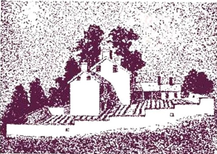
| Description | : | William Stover first appears on the Antrim Twp (present Franklin County) tax list in 1753. Having sold property in eastern Pennsylvania in 1754, he moved the family to land two miles northeast of Shady Grove. The house and surrounding structures are called Fort Stover because of the long stone wall, 22 inches thick and up to 12 feet high, reputedly built as protection from Indians. A stone outbuilding holds the bubbling headwaters of Marsh Creek. William Stover became the spiritual leader of the German Baptists (Dunkers) of this region. The family cemetery is on this property. The property... Read More |
frequently asked questions (FAQ):
-
Where is Fort Stover Cemetery?
Fort Stover Cemetery is located at Franklin County, USA.
-
Fort Stover Cemetery cemetery's updated grave count on graveviews.com?
0 memorials
Nearby Cemetories:
1. Amberson Union Cemetery
Amberson, Franklin County, USA
Coordinate: 39.8698570, -77.6753380
2. Piper Burial Ground
Amberson, Franklin County, USA
Coordinate: 39.9417000, -77.6644000
3. Stake Cemetery
Amberson, Franklin County, USA
Coordinate: 39.9567000, -77.6453000
4. Cedar Valley Mennonite Church Cemetery
Franklin County, USA
Coordinate: 39.9380860, -77.6748680
5. Center Methodist Church Cemetery
Franklin County, USA
Coordinate: 39.9459000, -77.7463000
6. Air Hill Cemetery
Chambersburg, Franklin County, USA
Coordinate: 39.9589729, -77.7540283
7. Besore Cemetery
Chambersburg, Franklin County, USA
Coordinate: 39.9994300, -77.6247400
8. Bethel Church Cemetery
Chambersburg, Franklin County, USA
Coordinate: 39.9825000, -77.7144000
9. Boyer Cemetery
Chambersburg, Franklin County, USA
Coordinate: 39.9410670, -77.6615500
10. Brechbill Cemetery
Chambersburg, Franklin County, USA
Coordinate: 39.9155000, -77.6244000
11. Brinzer-Brainer Cemetery
Chambersburg, Franklin County, USA
Coordinate: 39.8671500, -77.5821800
12. Browns Mill Old Baptist Brethren Church Cemetery
Chambersburg, Franklin County, USA
Coordinate: 39.9349823, -77.6633301
13. Calvary Mennonite Church Cemetery
Chambersburg, Franklin County, USA
Coordinate: 39.8698570, -77.6753380
14. Cedar Grove Cemetery
Chambersburg, Franklin County, USA
Coordinate: 39.9417000, -77.6644000
15. Chambersburg Mennonite Cemetery
Chambersburg, Franklin County, USA
Coordinate: 39.9567000, -77.6453000
16. Corpus Christi Cemetery
Chambersburg, Franklin County, USA
Coordinate: 39.9380860, -77.6748680
17. Crider Family Farm Cemetery
Chambersburg, Franklin County, USA
Coordinate: 39.9459000, -77.7463000
18. Criders Cemetery
Chambersburg, Franklin County, USA
Coordinate: 39.9589729, -77.7540283
19. Culbertson Mennonite Church Cemetery
Chambersburg, Franklin County, USA
Coordinate: 39.9994300, -77.6247400
20. Emanuel's Liberal United Brethren Church Cemetery
Chambersburg, Franklin County, USA
Coordinate: 39.9825000, -77.7144000
21. Falling Spring Presbyterian Church Cemetery
Chambersburg, Franklin County, USA
Coordinate: 39.9410670, -77.6615500
22. Falling Spring Reformed Mennonite Cemetery
Chambersburg, Franklin County, USA
Coordinate: 39.9155000, -77.6244000
23. Fetterhoff Chapel Cemetery
Chambersburg, Franklin County, USA
Coordinate: 39.8671500, -77.5821800
24. First Evangelical Lutheran Church Cemetery
Chambersburg, Franklin County, USA
Coordinate: 39.9349823, -77.6633301