
| Memorials | : | 0 |
| Location | : | Frankfurt am Main, Stadtkreis Frankfurt, Germany |
| Coordinate | : | 50.1099970, 8.5523180 |
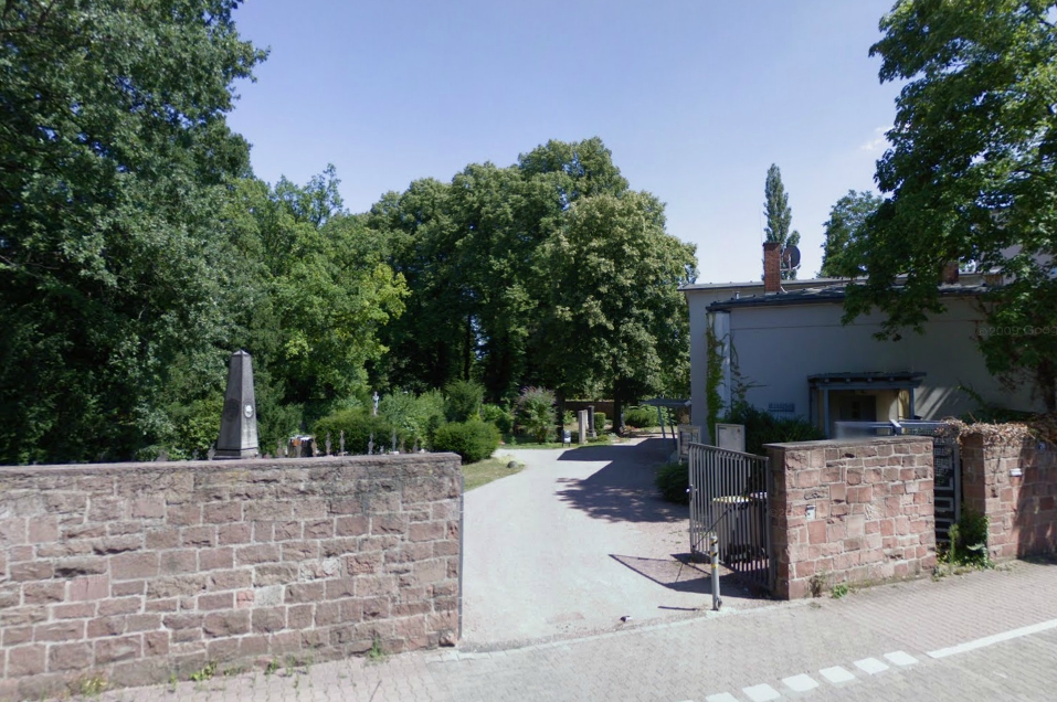
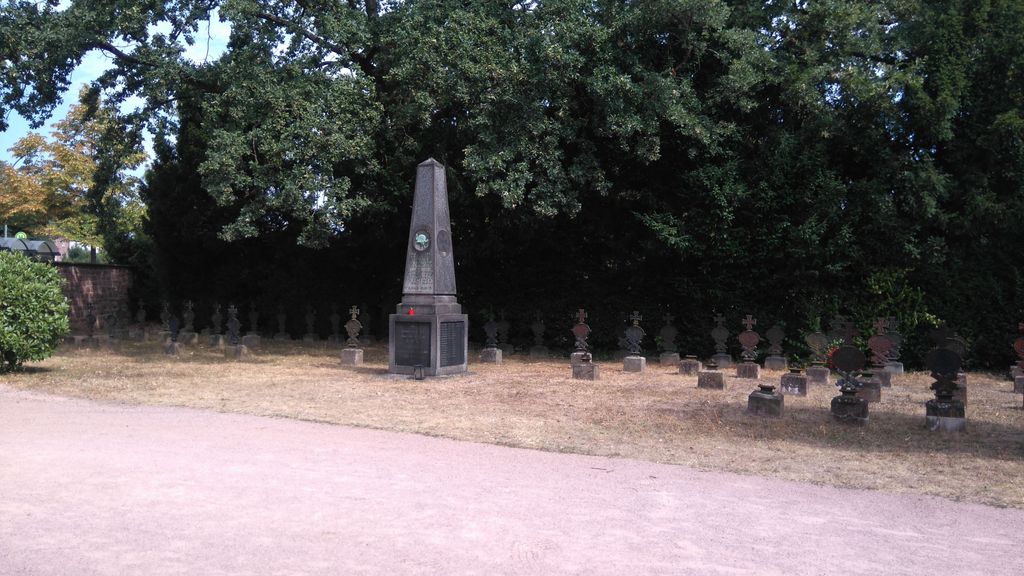
| Description | : | This cemetery was opened in 1889 and has a size of about 6 acres. It's also known as the old cemetery of Höchst (Alter Höchster Friedhof). In the middle of the cemetery is a WW I memorial with the names of almost 500 fallen sons of the city, who are all buried in foreign soil. There is also a WW I War Grave section with the remains of about 80 fallen soldiers. _______________________________________________ There are over 50 cemeteries and burial spots in Frankfurt, the links will be added as they are established on Findagrave: MUNICIPAL CEMETERIES: Hauptfriedhof Frankfurt Südfriedhof Frankfurt Alter Friedhof Oberrad Alter Friedhof Schwanheim Friedhof Bergen Friedhof... Read More |
frequently asked questions (FAQ):
-
Where is Friedhof Kurmainzer Strasse?
Friedhof Kurmainzer Strasse is located at Kurmainzer Strasse 70 Frankfurt am Main, Stadtkreis Frankfurt ,Hessen , 65936Germany.
-
Friedhof Kurmainzer Strasse cemetery's updated grave count on graveviews.com?
0 memorials
-
Where are the coordinates of the Friedhof Kurmainzer Strasse?
Latitude: 50.1099970
Longitude: 8.5523180
Nearby Cemetories:
1. Friedhof Höchst-Frankfurt
Frankfurt am Main, Stadtkreis Frankfurt, Germany
Coordinate: 50.1148900, 8.5479570
2. Friedhof Nied
Frankfurt am Main, Stadtkreis Frankfurt, Germany
Coordinate: 50.1034120, 8.5698230
3. Friedhof Unterliederbach
Frankfurt am Main, Stadtkreis Frankfurt, Germany
Coordinate: 50.1139390, 8.5282630
4. Friedhof Sossenheim
Frankfurt am Main, Stadtkreis Frankfurt, Germany
Coordinate: 50.1257680, 8.5660470
5. Alter Friedhof
Frankfurt am Main, Stadtkreis Frankfurt, Germany
Coordinate: 50.0904380, 8.5741730
6. Alter Friedhof Schwanheim
Schwanheim, Stadtkreis Frankfurt, Germany
Coordinate: 50.0902689, 8.5740180
7. Friedhof Griesheim
Frankfurt am Main, Stadtkreis Frankfurt, Germany
Coordinate: 50.1021590, 8.6020250
8. Jüdischer Friedhof Rödelheim I
Frankfurt am Main, Stadtkreis Frankfurt, Germany
Coordinate: 50.1257680, 8.5993710
9. Friedhof Rödelheim
Frankfurt am Main, Stadtkreis Frankfurt, Germany
Coordinate: 50.1231710, 8.6026430
10. Friedhof Eschborn
Eschborn, Main-Taunus-Kreis, Germany
Coordinate: 50.1483278, 8.5745140
11. Friedhof Sindlingen
Frankfurt am Main, Stadtkreis Frankfurt, Germany
Coordinate: 50.0779230, 8.5088300
12. Friedhof Zeilsheim
Frankfurt am Main, Stadtkreis Frankfurt, Germany
Coordinate: 50.0938490, 8.4887290
13. Jewish Cemetery Bad Soden
Bad Soden am Taunus, Main-Taunus-Kreis, Germany
Coordinate: 50.1320510, 8.4926030
14. Friedhof Westhausen
Frankfurt am Main, Stadtkreis Frankfurt, Germany
Coordinate: 50.1385290, 8.6050160
15. Friedhof Bad Soden
Bad Soden am Taunus, Main-Taunus-Kreis, Germany
Coordinate: 50.1367168, 8.4968770
16. Waldfriedhof Goldstein
Frankfurt am Main, Stadtkreis Frankfurt, Germany
Coordinate: 50.0760360, 8.6048230
17. Friedhof Hausen
Frankfurt am Main, Stadtkreis Frankfurt, Germany
Coordinate: 50.1332610, 8.6198470
18. Friedhof Kriftel
Kriftel, Main-Taunus-Kreis, Germany
Coordinate: 50.0878527, 8.4748995
19. Friedhof Niederrad
Frankfurt am Main, Stadtkreis Frankfurt, Germany
Coordinate: 50.0864180, 8.6307230
20. Alter Friedhof Bockenheim
Frankfurt am Main, Stadtkreis Frankfurt, Germany
Coordinate: 50.1184080, 8.6386630
21. Friedhof Praunheim
Frankfurt am Main, Stadtkreis Frankfurt, Germany
Coordinate: 50.1514690, 8.6200820
22. Friedhof Frankfurt-Bockenheim
Frankfurt am Main, Stadtkreis Frankfurt, Germany
Coordinate: 50.1359710, 8.6439190
23. Friedhof Heddernheim
Frankfurt am Main, Stadtkreis Frankfurt, Germany
Coordinate: 50.1535760, 8.6371630
24. Friedhof Niederursel
Frankfurt am Main, Stadtkreis Frankfurt, Germany
Coordinate: 50.1678590, 8.6153030