
| Memorials | : | 0 |
| Location | : | Rohrdorf, Landkreis Calw, Germany |
| Website | : | www.gemeinde-rohrdorf.de/de/leben-wohnen/oeffentliche-einrichtungen/friedhof |
| Coordinate | : | 48.5692400, 8.6905200 |
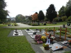
| Description | : | Friedhof der Gemeinde Rohrdorf, angelegt in drei Terassen am Ufer der Nagold. Fläche ca. 0,7 Hektar. Cemetery of the commune Rohrdorf, sloping on three levels on the bank of river Nagold. Area about 0.7 hectares. |
frequently asked questions (FAQ):
-
Where is Friedhof Rohrdorf?
Friedhof Rohrdorf is located at Wörthgasse 1 Rohrdorf, Landkreis Calw ,Baden-Württemberg , 72229Germany.
-
Friedhof Rohrdorf cemetery's updated grave count on graveviews.com?
0 memorials
-
Where are the coordinates of the Friedhof Rohrdorf?
Latitude: 48.5692400
Longitude: 8.6905200
Nearby Cemetories:
1. Friedhof Mindersbach
Mindersbach, Landkreis Calw, Germany
Coordinate: 48.5818240, 8.7027838
2. Friedhof Ebhausen
Ebhausen, Landkreis Calw, Germany
Coordinate: 48.5855860, 8.6817672
3. Friedhof Oberschwandorf
Oberschwandorf, Landkreis Calw, Germany
Coordinate: 48.5516519, 8.6627296
4. Friedhof Walddorf
Walddorf, Landkreis Calw, Germany
Coordinate: 48.5735449, 8.6520046
5. Jüdischer Friedhof Unterschwandorf
Unterschwandorf, Landkreis Calw, Germany
Coordinate: 48.5400514, 8.6860320
6. Friedhof Nagold
Nagold, Landkreis Calw, Germany
Coordinate: 48.5437799, 8.7126164
7. Ruhewald Nagold
Nagold, Landkreis Calw, Germany
Coordinate: 48.5414000, 8.7078000
8. Friedhof Pfrondorf
Pfrondorf, Landkreis Calw, Germany
Coordinate: 48.5916419, 8.7216124
9. Friedhof Emmingen
Emmingen, Landkreis Calw, Germany
Coordinate: 48.5847300, 8.7374600
10. Friedhof Rotfelden
Rotfelden, Landkreis Calw, Germany
Coordinate: 48.6093995, 8.6998371
11. Friedhof Ebershardt
Ebershardt, Landkreis Calw, Germany
Coordinate: 48.6082614, 8.6599317
12. Friedhof Beihingen
Beihingen, Landkreis Calw, Germany
Coordinate: 48.5400300, 8.6395900
13. Friedhof Egenhausen
Egenhausen, Landkreis Calw, Germany
Coordinate: 48.5640100, 8.6197300
14. Friedhof Iselshausen
Iselshausen, Landkreis Calw, Germany
Coordinate: 48.5263789, 8.7229854
15. Waldfriedhof Altensteig
Altensteig, Landkreis Calw, Germany
Coordinate: 48.5829700, 8.6174100
16. Friedhof Haiterbach
Haiterbach, Landkreis Calw, Germany
Coordinate: 48.5248540, 8.6533360
17. Friedhof Wenden
Wenden, Landkreis Calw, Germany
Coordinate: 48.6206200, 8.6654934
18. Friedhof Gündringen
Gündringen, Landkreis Calw, Germany
Coordinate: 48.5153060, 8.7070109
19. Friedhof Effringen
Effringen, Landkreis Calw, Germany
Coordinate: 48.6227681, 8.7168958
20. Friedhof Altensteigdorf
Altensteigdorf, Landkreis Calw, Germany
Coordinate: 48.5936552, 8.6133782
21. Friedhof Vollmaringen
Vollmaringen, Landkreis Calw, Germany
Coordinate: 48.5257110, 8.7466090
22. Friedhof Oberjettingen
Oberjettingen, Landkreis Böblingen, Germany
Coordinate: 48.5800667, 8.7755232
23. Friedhof Unterjettingen
Unterjettingen, Landkreis Böblingen, Germany
Coordinate: 48.5662152, 8.7776157
24. Friedhof Wildberg
Wildberg, Landkreis Calw, Germany
Coordinate: 48.6211312, 8.7303742