
| Memorials | : | 0 |
| Location | : | Kreis Bergstraße, Germany |
| Coordinate | : | 49.4527220, 8.9094440 |
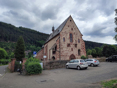
| Description | : | The Catholic Church known as the Ersheimer Chapel St. Nazarius and Celsus in Ersheim is considered as the oldest church of the Neckar Valley, gem of regional Gothic. A first church existed in its place probably in the 8th or 9th century, the oldest parts of today's date from the 14th century, when the Church was the burial place of the Lords of Hirschhorn. The Church is older than the town on the opposite bank of the Neckar Hirschhorn and was the parish church of the city, at the temporarily up to five Altaristen worked alongside a pastor (only with... Read More |
frequently asked questions (FAQ):
-
Where is Friedhofskirche St. Nazarius und Celsus in Ersheim?
Friedhofskirche St. Nazarius und Celsus in Ersheim is located at Kreis Bergstraße ,Hessen ,Germany.
-
Friedhofskirche St. Nazarius und Celsus in Ersheim cemetery's updated grave count on graveviews.com?
0 memorials
-
Where are the coordinates of the Friedhofskirche St. Nazarius und Celsus in Ersheim?
Latitude: 49.4527220
Longitude: 8.9094440
Nearby Cemetories:
1. Friedhof Brombach
Neckargerach, Neckar-Odenwald-Kreis, Germany
Coordinate: 49.4918900, 8.8655800
2. Jüdischer Friedhof Eberbach
Eberbach, Rhein-Neckar-Kreis, Germany
Coordinate: 49.4684600, 8.9888900
3. Eberbacher Friedhof
Eberbach, Rhein-Neckar-Kreis, Germany
Coordinate: 49.4680475, 8.9902500
4. Friedhof Neckarsteinach
Neckarsteinach, Kreis Bergstraße, Germany
Coordinate: 49.4061800, 8.8421700
5. Kloster Schönau
Heidelberg, Stadtkreis Heidelberg, Germany
Coordinate: 49.4357830, 8.8095440
6. Evangelische Kirche
Kreis Bergstraße, Germany
Coordinate: 49.4000000, 8.8333330
7. Friedhof Neckargemünd
Neckargemünd, Rhein-Neckar-Kreis, Germany
Coordinate: 49.3913000, 8.7947300
8. Neuer Friedhof Schlierbach-Heidelberg
Schlierbach, Stadtkreis Heidelberg, Germany
Coordinate: 49.4127458, 8.7657911
9. Alter Friedhof Ziegelhausen
Heidelberg, Stadtkreis Heidelberg, Germany
Coordinate: 49.4197240, 8.7597160
10. Neuer Friedhof Ziegelhausen
Heidelberg, Stadtkreis Heidelberg, Germany
Coordinate: 49.4213550, 8.7464950
11. Friedhof Altenbach
Schriesheim, Rhein-Neckar-Kreis, Germany
Coordinate: 49.4869796, 8.7414323
12. Friedhof Beerfelden
Odenwaldkreis, Germany
Coordinate: 49.5622900, 8.9622300
13. Friedhof Ursenbach
Schriesheim, Rhein-Neckar-Kreis, Germany
Coordinate: 49.4935716, 8.7282863
14. Friedhof Oberflockenbach
Weinheim, Rhein-Neckar-Kreis, Germany
Coordinate: 49.5123988, 8.7353531
15. Friedhof Binau
Binau, Neckar-Odenwald-Kreis, Germany
Coordinate: 49.3674374, 9.0626862
16. Jüdischer Friedhof Binau
Binau, Neckar-Odenwald-Kreis, Germany
Coordinate: 49.3679600, 9.0646100
17. Heiliggeistkirche
Heidelberg, Stadtkreis Heidelberg, Germany
Coordinate: 49.4122220, 8.7094440
18. Jüdischer Friedhof Klingenteich
Heidelberg, Stadtkreis Heidelberg, Germany
Coordinate: 49.4077412, 8.7078480
19. Peterskirche
Heidelberg, Stadtkreis Heidelberg, Germany
Coordinate: 49.4094440, 8.7058330
20. Etzean Friedhof
Etzean, Odenwaldkreis, Germany
Coordinate: 49.5879630, 8.9724120
21. Jüdischer Friedhof Meckesheim
Meckesheim, Rhein-Neckar-Kreis, Germany
Coordinate: 49.3200700, 8.8237200
22. Friedhof Handschuhsheim
Handschuhsheim, Stadtkreis Heidelberg, Germany
Coordinate: 49.4331600, 8.6865100
23. Friedhof Handschuhsheim
Heidelberg, Stadtkreis Heidelberg, Germany
Coordinate: 49.4330540, 8.6864130
24. Parkfriedhof
Großostheim, Landkreis Aschaffenburg, Germany
Coordinate: 49.4034944, 8.6941696