
| Memorials | : | 1 |
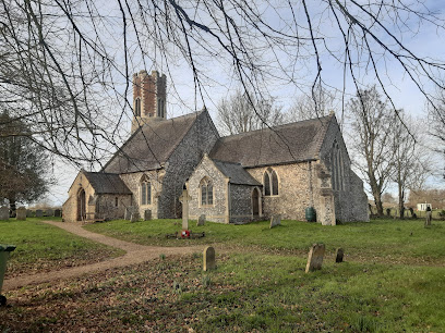
| Location | : | Shepshed, Charnwood Borough, England |
| Coordinate | : | 52.7711000, 1.2951000 |
| Description | : | Garendon Abbey was founded in 1133 by Robert, Earl of Leicester. It was in all probability a daughter house of Waverley, the earliest Cistercian monastery to be established in England.The founder endowed the abbey with 5 carucates and 3 virgates of land at Garendon, a burgage tenement at Leicester, and other lands at Dishley, Shepshed, and Ringolthorp. During the 12th century various benefactors granted to the abbey lands at Eastwell, (fn. 4) Ibstock, Welby, Burton on the Wolds,and Stanton under Bardon, in Leicestershire, at Costock (Notts.), and at Heathcote (Derbys.). The wild country of Charnwood Forest, in which... Read More |
frequently asked questions (FAQ):
-
Where is Garendon Abbey?
Garendon Abbey is located at Shepshed, Charnwood Borough ,Leicestershire ,England.
-
Garendon Abbey cemetery's updated grave count on graveviews.com?
1 memorials
-
Where are the coordinates of the Garendon Abbey?
Latitude: 52.7711000
Longitude: 1.2951000
Nearby Cemetories:
1. St. Peter's Churchyard
Brampton, Broadland District, England
Coordinate: 52.7733970, 1.2891100
2. St. Michael & All Angels Churchyard
Oxnead, Broadland District, England
Coordinate: 52.7680820, 1.3042030
3. St. Mary's Churchyard
Burgh Next Aylsham, Broadland District, England
Coordinate: 52.7775114, 1.2865926
4. St Andrew Churchyard
Buxton, Broadland District, England
Coordinate: 52.7557360, 1.3083760
5. Quaker Burial Ground
Lamas, Broadland District, England
Coordinate: 52.7584960, 1.3235840
6. St. Andrew Churchyard
Lamas, Broadland District, England
Coordinate: 52.7598010, 1.3262770
7. All Saints Churchyard
Marsham, Broadland District, England
Coordinate: 52.7661840, 1.2549020
8. St Peter & St Paul's Church
Tuttington, Broadland District, England
Coordinate: 52.7962090, 1.3009760
9. St Mary The Virgin and St Botolph Churchyard
Hevingham, Broadland District, England
Coordinate: 52.7536400, 1.2605000
10. Aylsham Cemetery
Aylsham, Broadland District, England
Coordinate: 52.7883400, 1.2540900
11. St. Margaret's Churchyard
Stratton Strawless, Broadland District, England
Coordinate: 52.7387400, 1.2899900
12. St. Michael and All Angels Churchyard
Aylsham, Broadland District, England
Coordinate: 52.7960690, 1.2506530
13. All Saints Churchyard (Old Church)
Hainford, Broadland District, England
Coordinate: 52.7284190, 1.3004104
14. St. Botolph Churchyard
Banningham, North Norfolk District, England
Coordinate: 52.8170850, 1.2865060
15. St. Andrews Church Burial Ground
Felmingham, North Norfolk District, England
Coordinate: 52.8139100, 1.3391320
16. All Saints Churchyard
Horstead, Broadland District, England
Coordinate: 52.7294900, 1.3499140
17. Silvergate Lane Cemetery
Blickling, Broadland District, England
Coordinate: 52.8075334, 1.2305140
18. St Andrew Churchyard
Blickling, Broadland District, England
Coordinate: 52.8095370, 1.2311760
19. Blickling Hall
Blickling, Broadland District, England
Coordinate: 52.8095474, 1.2310860
20. St Swithin Churchyard
Frettenham, Broadland District, England
Coordinate: 52.7177780, 1.3223060
21. St. John the Baptist Churchyard
Coltishall, Broadland District, England
Coordinate: 52.7278530, 1.3626450
22. St. Giles Churchyard
Colby, North Norfolk District, England
Coordinate: 52.8318190, 1.2945700
23. St. Mary's Churchyard
Erpingham, North Norfolk District, England
Coordinate: 52.8338580, 1.2626100
24. St. Peter's Churchyard
Haveringland, Broadland District, England
Coordinate: 52.7427900, 1.1857300